|
| A massive tongue of
cold air protrudes into southern Qld in these charts for 10pm today.
At the 500hPa pressure level (above), about 5.7km up, temperatures
are around -20 almost to the tropics. The June average at this level
at Charleville is -14.5. Closer to the surface, the 850hPa chart (below),
about 1.5km above sea level, shows temperatures between 3 and 9° cover
most of Qld coupled with a fresh southeasterly flow and a band of
90%+ humidity. Fiorino |
 |
The trough of cold upper air and associated
cloud band that gave unseasonably heavy rain to the Gulf country yesterday
moved southeast into eastern Queensland today giving widespread rainfalls
of 20 to 60mm. With cold upper temperatures providing the uplift and ample
moisture still being fed in by surface southeasterlies, heavy rain for June
occurred on the coast and spread well inland. A small low that developed
east of Townsville around midday also helped to strengthen winds onto the
central and south Qld coasts. Double Island Point Lighthouse, NE
of Gympie, recorded 65mm for the 24 hours to 9am, as did Dalrymple Heights,
atop the Eungella escarpment to the west of Mackay. Sellheim, NE
of Charters Towers, recorded 58.8mm and Einasleigh township, 300km
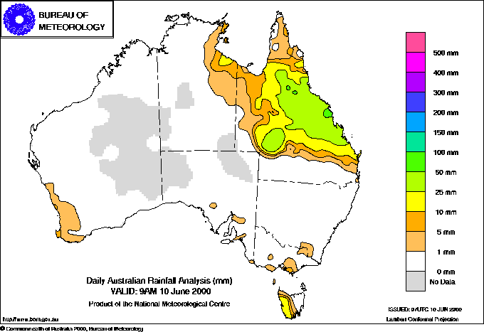
WNW of Townsville, registered 57. The maps below show the widespread distribution
of the rain in the 24 hours to 9 this morning, and also the weekly totals
to 9am Sunday. A look at the short term rainfall figures in the Other
extremes box below shows that the heaviest rain fell steadily over many
hours rather than in heavy bursts. Grain growers in the central highlands
recorded 30 to 50mm, producing one of the best starts to the season in years.
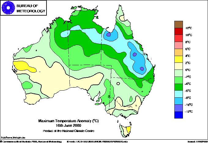
Daytime temperatures across the region
were again below normal by up to 11°, with the whole bottom 10km or so
of the atmosphere 6 to 8° colder than normal for June.
 |
Rainfall for the 24
hours to 9 this morning (left) and the week to 9am Sunday (below left).
Maximum temperatures across most of northern and eastern Queensland
were again way below normal today (below). |
 |
 |
Western Australia's southwest was buffeted
by gale force winds during the morning as an unusual pair of cold fronts
crossed the coastline. Gusts of 108km/h were recorded at Busselton, Cape
Naturaliste and Albany. The change was unusual in several ways. Frontal
passages in SW WA in winter usually swing the wind to the W or SW and introduce
cooler moister maritime air. In Perth, the temperature dropped from
17° at 4am to 11.9 at 7am after the first change, but though it later
rose to the mid-teens, the day felt much colder due to the strong winds
and abnormally low humidity after the change. At Albany Airport,
for example, the 2am temperature ahead of the first change was 17.5° with
a dew point of -4.5° making the relative humidity 22%. The first change
dropped the temperature at 4.30am to 12.4 and raised dew point to 6.8 and
humidity to 68%, though the wind stayed northerly. The second change passed
through around 6.30am after which the temperature rose by 7.30am to 14.8,
dew point dropped to 1.6 and humidity to 40%. The wind remained steadfastly
from the north, only swinging NNW late in the afternoon. Not unsurprisingly,
little rain was reported with the change, but dust storms were with both
Carnarvon and Albany Airport observers reporting raised dust
or sand at their midday observations. |