 |
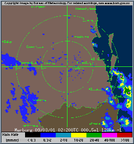
| Radar animation for the 11 hours from 12.20 to 11.20pm in 20 minute steps. The movement of the area of heavy rain in the opposite direction to overall storm and shower movement in the area is clear. The UTC times at the bottom of the frame are 10 hours behind EST. The concentric circles are 50 and 100km from Marburg radar, which is situated 50km WSW of Brisbane CBD. BOM radar, animated by AWN |
The storm's most exceptional feature was a slow-moving area of torrential rain that drifted northwards against the prevailing airstream for over 8 hours. The radar sequence at right begins with a cluster of storms crossing the Gold Coast during the early afternoon. This grew from a line of storms that had been lying offshore since before dawn in the tropically warm, moist and unstable environment remaining around the ex-Tasman Sea low (see report yesterday), now stagnating near the Border Ranges. As the residents of the NSW North Coast could attest after watching over 500mm of rain fall over the past couple of days, a huge amount of moisture was available for precipitation in this airmass.
Up to about 4pm (06UTC), the storms can be seen to lie in a zone of converging air, with the main steering wind over land coming from the NNW, but cloud cells near the coast moving in from the NNE or NE on a building sea breeze. The storms crossed the Gold Coast shoreline soon after 1pm, and by 3pm the seabreeze convergence line had stalled south of Brisbane in the Logan area. Logan City received 284mm for the 24 hours to 9am Saturday, most falling in about 2 hours. There was an unofficial recording of 200mm falling in 55 minutes.
Between 3 and 7pm (05 to 09UTC), the area of torrential rain moved only very slowly northwards and expanded to cover most of the central Brisbane metropolitan area. Many areas in southeast Brisbane were covered for two hours or more by green or pink on the radar, corresponding to rainfall rates between 20 and 100mm/hour. This agrees with widespread readings between 150 and 250mm in the area for the 24 hours to 9am Saturday (see Saturday's rain list), almost all of which fell during the storm. Although individual cells can be seen on the radar moving SSE with the steering wind, the system as a whole appears to be backbuilding to the north along the seabreeze convergence line.
The worst of the storm coincided with a Friday peak hour, with heavy traffic slowed to a crawl in rain and runoff that made it hard to locate the road. By early evening, most main roads in Brisbane were blocked by floodwaters, erupting stormwater drains, accidents and debris. The Gateway Motorway, Logan Road, Ipswich Road, the Western Freeway and many others were inundated by more than a metre of water in places, and traffic was still in gridlock at 9.30pm. Many cars were washed off roads or out of car yards as creeks broke their banks, while some were seen floating in rapidly-filling underground carparks. In the eastern suburbs, a boat was washed against a business building. The railway between Brisbane and the Gold Coast was cut north of Beenleigh, and Brisbane Airport closed due to the storm and half the runway lights blacking out.
The build-up of stormwater put up to half a metre or more of muddy water through 400 to 500 businesses and hundreds of houses, leaving residents desperately trying to rescue belongings. In the inner southern suburbs of Yeronga and Coorparoo, rescue teams had to move elderly people trapped in low-lying homes. There were reports of people in trees and on roofs waiting to be rescued by SES personnel who were themselves immobilised by the situation. Squally winds from storm downdrafts combined with saturated ground to bring down trees and powerlines, while several home units lost roofs. The SES received over 600 calls for help. 29,000 residences were left without power after the storm, with 2,500 still blacked out on Saturday morning.
After about 7pm (09UTC), the area of heavy rain contracted slowly north of Brisbane, with several active, slow-moving cells along a line just inland from the coast and north to Maroochydore and Gympie. One of these cells produced 153.2mm in the hour to 8pm at Nambour, with a total for the event there of 195mm.
Several of the reported rainfall intensities (see the high short-duration rainfall table below) exceed the engineering average return period of 100 years, leading to press reports of this being "a one-hundred year storm." The Nambour one-hour recording of 153.2mm compares with a statistical 100-year return interval amount of 102mm, while the reported 200mm in 55 minutes at Logan City compares with a 1 in 100 year likelihood of 108mm! Archerfield's 94mm in 90 minutes has about a 23 year return period, while Brisbane City's 100.2mm in 90 minutes has a 25 year return period. While the statistics become dubious when pushed to the edge like this, they give some indication of the immensity of the deluge. Similar extreme flash flood events occurred in SE Qld at Cooyar, 130km NW of Brisbane, in 1988 and at Boonah, 70km SW of the city, in 1991. Today's event, however, washed across a city of over a million people.
Damage will run into tens of millions of dollars, but it was the incalculable cost of a 12-year-old boy's life lost, when he and his mother's car was swept at the height of the storm into a creek off Todds Road, Lawnton, north of Brisbane, that weighed most on Brisbanites as they set to on Saturday to clean up the mess.
Natural disaster relief was activated on Monday 12 March.
My thanks to Ben Quinn, John Woodbridge, Anthony Cornelius, James Chambers and Dave Williams for information over and above the normal press and weather reports.
For additional reports, see Brisbane Storm Chasers and the Brisbane Storms site