 |
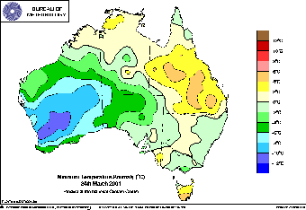
| The series of charts (above) shows minimum temperature departure from average over the seven nights from 24 to 30 March 2001. Light blue areas are 6 to 8° below the March average, dark blue areas 10 to 12 below. Record or near record low March minima were recorded as this cold airmass amplified north and east across the country. BoM |
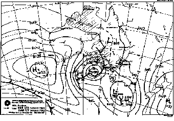 |
| Above: Surface synoptic
chart for 8am WST Saturday 24 March shows the deep southerly fetch
of the airmass that spread over all of WA and into the NT later in
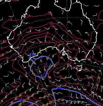
the week BoM. Below: The situation at 850hPa, about 1,4km up, at the same time. Wind arrows again show the southerly fetch of the airmass, while the isotherms show a blob of sub-zero temperature air making its way northwards as it detaches from the normal westerly circulation. FNMOC |
 |
A seemingly innocuous surge of cool, dry southern air moved into WA on Saturday 24 March, heralding a week of record-breaking low overnight temperatures in the west, north and southeast of the country.
The airmass originated well south of the continent, around 60°S, on 22 March, and was swung NNW during the 23rd and 24th around the western side of the secondary low shown on the surface chart (centre right). The airmass lodged over northern and eastern WA for several days before extending eastwards into the southern NT and northern SA, then southeastwards into NSW on 29 March. A second wave of colder air passing under Australia on the 30th helped prolong cold spell.
With much of this area cooled by several weeks of cold daytime temperatures, the arrival of very dry air from the south allowed night time temperatures to plummet. This table shows the extraordinary duration and intensity of cold nights, especially in the northern half of Western Australia and the Alice Springs region.
A number of stations with long records broke their previous March low minimum record on two or three occasions. Giles Met Office, close to where the WA, NT and SA borders meet, broke its previous record of 10.6 in 44 years of observation on the 25th, 26th and 28th, while Nyang Station in the Gascoyne, with 27 years of observation, broke its previous record on 5 occasions in 6 days. Many recording stations in the Pilbara, Gascoyne and NE WA were within 3° of their record lows on 7 or 8 of the mornings between 24 and 31 March.
Details of individual station records can be found in the National Extremes for each day.