|
For notes on how to interpret
the data and quality control issues, see Daily Weather Summary Help.
**S** and **W** precede data flagged by the Bureau as suspicious or wrong
Data is as received at 09:24EST, 24/05/2012.
|
|
| |
Max
°
C |
+/- norm
°
C |
Min
°
C |
+/- norm
°
C |
Grass Min
°
C |
Rain to 9am mm |
Evaporation to 9am mm |
Sunshine hours |
Wind Run to 9am km (24-hour average km/h) |
Maximum Gust km/h / hour of occurrence |
| GERALDTON AIRPORT |
31.0 |
+1.5 |
20.5 |
+4.2 |
18.8 |
0.0 |
9.4 |
-- |
754 (31.4) |
57/17 |
| PERTH AIRPORT |
36.3 |
+7.4 |
19.3 |
+4.5 |
16.7 |
0.0 |
11.4 |
13.2 |
509 (21.2) |
52/22 |
| ALBANY AIRPORT |
21.8 |
-1.3 |
12.6 |
+0.2 |
9.8 |
0.0 |
6.0 |
9.2 |
231 ( 9.6) |
37/14 |
| BUNBURY |
33.4 |
+6.3 |
14.7 |
+1.4 |
-- |
0.0 |
-- |
-- |
409 (17.0) |
52/17 |
| MANDURAH |
30.4 |
-- |
18.3 |
-- |
-- |
0.0 |
-- |
-- |
526 (21.9) |
55/16 |
| DARWIN AIRPORT |
32.1 |
-0.5 |
26.2 |
+0.9 |
25.3 |
0.0 |
5.2 |
8.1 |
363 (15.1) |
39/16 |
| ALICE SPRINGS AIRPORT |
38.0 |
+2.6 |
20.1 |
-0.1 |
19.6 |
0.0 |
15.2 |
9.8 |
-- |
-- |
| WHYALLA AERO |
44.5 |
+16.4 |
24.6 |
+8.8 |
-- |
0.0 |
16.0 |
-- |
365 (15.2) |
65/09 |
| ADELAIDE (KENT TOWN) |
36.9 |
+9.9 |
23.3 |
+7.8 |
-- |
0.0 |
11.8 |
12.6 |
313 (13.0) |
54/09 |
| MOUNT GAMBIER AERO |
35.0 |
+12.1 |
13.0 |
+3.1 |
11.8 |
0.0 |
6.6 |
13.0 |
355 (14.8) |
72/11 |
| MOUNT ISA AERO |
38.1 |
+0.9 |
23.1 |
0.0 |
20.8 |
0.0 |
6.0 |
10.0 |
287 (12.0) |
39/23 |
| CAIRNS AERO |
32.5 |
+1.1 |
25.1 |
+1.7 |
24.0 |
1.2 |
6.4 |
7.7 |
312 (13.0) |
44/13 |
| TOWNSVILLE AERO |
30.6 |
-0.9 |
25.4 |
+1.3 |
23.1 |
0.6 |
5.6 |
1.0 |
331 (13.8) |
43/11 |
| MACKAY M.O |
28.9 |
-1.2 |
23.8 |
+0.9 |
-- |
6.2 |
-- |
8.1 |
415 (17.3) |
43/09 |
| ROCKHAMPTON AERO |
30.5 |
-1.6 |
23.4 |
+2.2 |
22.2 |
0.0 |
6.4 |
-- |
365 (15.2) |
34/02 |
| BUNDABERG AERO |
30.3 |
+0.9 |
20.9 |
+0.4 |
-- |
0.0 |
-- |
-- |
408 (17.0) |
44/14 |
| NAMBOUR DPI |
28.0 |
-1.2 |
21.0 |
+2.8 |
-- |
0.0 |
-- |
-- |
-- |
-- |
| COOLANGATTA |
28.6 |
+1.4 |
20.8 |
+0.9 |
-- |
0.0 |
-- |
-- |
372 (15.5) |
50/12 |
| BRISBANE AERO |
27.8 |
-0.5 |
20.4 |
+0.3 |
19.2 |
0.0 |
6.8 |
12.6 |
375 (15.6) |
43/11 |
| TOOWOOMBA AIRPORT |
26.5 |
-1.2 |
16.5 |
-0.2 |
-- |
0.0 |
-- |
-- |
581 (24.2) |
48/07 |
| GUNNEDAH RESOURCE CENTRE |
34.2 |
+3.2 |
21.2 |
+3.7 |
16.1 |
0.0 |
7.0 |
-- |
93 ( 3.9) |
-- |
| COFFS HARBOUR MO |
27.1 |
+0.8 |
18.6 |
+0.5 |
17.5 |
0.0 |
5.2 |
12.9 |
217 ( 9.0) |
22/11 |
| PORT MACQUARIE AIRPORT AWS |
27.0 |
+0.4 |
17.0 |
+0.3 |
-- |
0.0 |
-- |
-- |
-- |
-- |
| WILLIAMTOWN RAAF |
33.0 |
+5.8 |
17.1 |
+0.6 |
14.7 |
0.0 |
9.2 |
11.9 |
296 (12.3) |
37/15 |
| GOSFORD (NARARA RESEARCH STATION) AWS |
30.3 |
+3.4 |
16.2 |
+0.9 |
-- |
0.0 |
-- |
-- |
69 ( 2.9) |
28/14 |
| ORANGE AGRICULTURAL INSTITUTE |
29.5 |
+5.1 |
15.0 |
+3.7 |
6.0 |
0.0 |
8.0 |
13.6 |
-- |
-- |
| DUBBO AIRPORT AWS |
35.3 |
+3.8 |
17.0 |
+1.1 |
-- |
0.0 |
-- |
-- |
241 (10.0) |
28/16 |
| SYDNEY AIRPORT AMO |
29.5 |
+3.8 |
21.9 |
+4.4 |
19.8 |
0.0 |
8.8 |
11.7 |
422 (17.6) |
57/17 |
| RICHMOND RAAF |
35.1 |
+6.4 |
16.8 |
+0.8 |
-- |
0.0 |
-- |
-- |
123 ( 5.1) |
31/16 |
| BELLAMBI AWS |
25.4 |
+1.3 |
19.5 |
+2.0 |
-- |
0.0 |
-- |
-- |
183 ( 7.6) |
43/17 |
| CANBERRA AIRPORT COMPARISON |
33.0 |
+6.9 |
12.0 |
+0.6 |
11.0 |
0.0 |
-- |
-- |
-- |
-- |
| WAGGA WAGGA AMO |
38.1 |
+8.7 |
15.7 |
+2.0 |
9.8 |
0.0 |
10.4 |
13.6 |
234 ( 9.8) |
26/13 |
| ALBURY AIRPORT AWS |
38.1 |
+8.7 |
15.7 |
+2.0 |
-- |
0.0 |
-- |
-- |
165 ( 6.9) |
46/14 |
| MILDURA AIRPORT |
42.1 |
+12.0 |
22.1 |
+7.3 |
17.3 |
0.0 |
11.0 |
12.8 |
303 (12.6) |
50/13 |
| TATURA INST SUSTAINABLE AG |
39.2 |
+11.8 |
14.4 |
+2.2 |
-- |
0.0 |
7.2 |
-- |
235 ( 9.8) |
46/13 |
| BENDIGO AIRPORT |
40.8 |
+13.8 |
16.3 |
+4.8 |
-- |
0.0 |
-- |
-- |
277 (11.5) |
�
65/13 |
| MELBOURNE REGIONAL OFFICE |
41.1 |
+16.9 |
14.9 |
+2.0 |
13.2 |
0.0 |
6.0 |
-- |
-- |
-- |
| GROVEDALE (GEELONG AIRPORT) |
42.3 |
+19.4 |
9.4 |
-1.5 |
-- |
0.0 |
-- |
-- |
215 ( 9.0) |
85/13 |
| BALLARAT AERODROME |
37.6 |
+15.0 |
13.0 |
+3.6 |
-- |
0.0 |
-- |
-- |
346 (14.4) |
81/13 |
| LAUNCESTON (TI TREE BEND) |
26.0 |
+3.6 |
9.0 |
-1.6 |
-- |
0.0 |
-- |
-- |
203 ( 8.5) |
30/14 |
| HOBART AIRPORT |
26.3 |
+5.7 |
7.3 |
-3.4 |
4.0 |
0.0 |
8.8 |
13.0 |
300 (12.5) |
35/17 |
| |
Max
°
C |
+/- norm
°
C |
Min
°
C |
+/- norm
°
C |
Grass Min
°
C |
Rain to 9am mm |
Evaporation to 9am mm |
Sunshine hours |
Wind Run to 9am km |
Maximum Gust km/h / hour of occurrence |
|
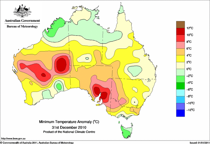
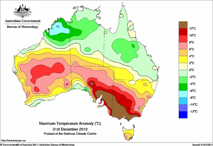
| Hottest |
| Highest maximum temperature> | Greatest variation above normal maximum |
Highest minimum temperature | Greatest variation above normal minimum |
46.1 GASCOYNE JUNCTION W Gascoyne WA
45.8 EMU CREEK STATION W Gascoyne WA
45.6 CARNEGIE Interior WA
45.6 PARABURDOO AERO E Gascoyne WA
45.5 PORT AUGUSTA AERO W Agricultural SA
|
+19.4 : 42.3 GEELONG AIRPORT W Central VIC
+19.0 : 40.1 AIREYS INLET W Coast VIC
+18.8 : 42.8 AVALON AIRPORT W Central VIC
+18.2 : 41.9 LAVERTON RAAF W Central VIC
+17.0 : 38.2 PORT FAIRY AWS W Coast VIC
|
32.1 WARBURTON AIRFIELD Interior WA
31.4 GILES METEOROLOGICAL OFFICE Interior WA
30.1 MEEKATHARRA AIRPORT E Gascoyne WA
30.0 LEINSTER AERO Goldfields WA
30.0 LEONORA AERO Goldfields WA
|
+13.7 : 26.2 ROSEWORTHY AWS Adelaide/Lofty SA
+12.3 : 25.7 ROSEDALE (TURRETFIELD RESEARCH CENTRE) Adelaide/Lofty SA
+12.1 : 23.0 MOUNT LOFTY Adelaide/Lofty SA
+11.7 : 23.9 SNOWTOWN (RAYVILLE PARK) Lower North SA
+11.6 : 26.5 NONNING NW Pastoral SA
+11.6 : 25.5 KIMBA W Agricultural SA
|
| Coldest |
| Lowest maximum temperature | Greatest variation below normal maximum |
Lowest minimum temperature | Greatest variation below normal minimum |
15.4 TASMAN ISLAND Southeast TAS
16.7 MOUNT WELLINGTON Southeast TAS
17.3 MAATSUYKER ISLAND LIGHTHOUSE Southeast TAS
17.9 WYNYARD AIRPORT N Coast TAS
18.3 LOW HEAD N Coast TAS
|
-6.9 : 27.0 KURI BAY N Kimberley WA
-6.8 : 27.2 MOUNT ELIZABETH N Kimberley WA
-6.7 : 31.8 WARMUN E Kimberley WA
-6.5 : 28.0 DOONGAN N Kimberley WA
-6.4 : 31.5 WYNDHAM AERO N Kimberley WA
|
-0.2 LAKE ST CLAIR NATIONAL PARK Central Plateau TAS
0.0 BUTLERS GORGE Central Plateau TAS
1.5 LIAWENEE Central Plateau TAS
2.5 OUSE FIRE STATION Derwent Valley TAS
3.0 MAYDENA POST OFFICE Derwent Valley TAS
|
-7.3 : 4.5 FLINDERS ISLAND AIRPORT Flinders Is/Bass St TAS
-6.2 : 3.4 SMITHTON AERODROME N Coast TAS
-6.1 : 2.5 OUSE FIRE STATION Derwent Valley TAS
-5.7 : 4.2 CAMPANIA (KINCORA) Southeast TAS
|
|
Sunniest &
dullest |
Windiest |
Highest gusts |
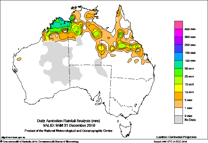
Todays highest rainfall totals for the 24 hours to 9am. It
includes the top 5 totals nationally followed by all reported falls of 50mm or more. |
Highest
and lowest recordings of hours of sunshine for the 24 hours to midnight. |
Highest wind
run totals in kilometres for the 24 hours to 9am (average speed in brackets).
All reported runs >
=25km/h are shown. |
Highest wind
gusts in km/h for the 24 hours to midnight followed by the hour in which it occurred.
All stations with gusts >
89km/h are shown. |
132.0 FARAWAY BAY N Kimberley WA
119.2 HOME VALLEY N Kimberley WA
90.0 DOONGAN N Kimberley WA
79.8 RONLOW PARK Central West QLD
73.6 PORT KEATS AERO N Rivers NT
WESTERN AUSTRALIA
N Kimberley
132.0 FARAWAY BAY
119.2 HOME VALLEY
90.0 DOONGAN
70.2 DRYSDALE RIVER STATION
64.4 EMMA GORGE
58.4 KURI BAY
58.0 DIGGERS REST
56.0 WYNDHAM
55.4 WYNDHAM AERO
53.4 EL QUESTRO
51.3 MOUNT ELIZABETH
50.4 KALUMBURU
E Kimberley
64.0 KUNUNURRA CHECKPOINT
58.4 KUNUNURRA AERO
W Kimberley
62.0 CHARNLEY RIVER
52.0 MOUNT HOUSE STATION
NORTHERN TERRITORY
N Rivers
73.6 PORT KEATS AERO
55.2 KEEP RIVER RANGERS
N Plateau
61.7 SOUDAN
QUEENSLAND
N Coast--Barron
54.0 HAZELMERE
Central Coast E
**S** 71.4 COLLINSVILLE POST OFFICE
Central Coast W
50.5 BRUSLEE
Central West
79.8 RONLOW PARK
61.0 CAMERON DOWNS
Wide Bay/Burnett
53.8 BARWOOD
Brisbane/SE Coast
54.2 FRASER ISLAND EURONG
ISLANDS
Islands
53.2 CHRISTMAS ISLAND AERO
|
13.6 ORANGE AGRICULTURAL INSTITUTE C Tablelands S NSW
13.6 WAGGA WAGGA AMO SW Slopes S NSW
13.5 LIAWENEE Central Plateau TAS
13.2 PERTH AIRPORT Lower West WA
13.2 GILES METEOROLOGICAL OFFICE Interior WA
13.2 ADELAIDE AIRPORT Adelaide/Lofty SA
.....
4.8 GOVE AIRPORT N Rivers NT
4.5 LARRIMAH N Rivers NT
2.1 BROOME AIRPORT W Kimberley WA
1.0 TOWNSVILLE AERO N Coast--Herbert QLD
0.0 NORFOLK ISLAND AERO Islands ISL
|
999 (41.6) DOUBLE ISLAND POINT LIGHTHOUSE Brisbane/SE Coast QLD
943 (39.3) CAPE MORETON LIGHTHOUSE Brisbane/SE Coast QLD
938 (39.1) ROTTNEST ISLAND Lower West WA
917 (38.2) NORTH ISLAND Central West WA
795 (33.1) RUNDLE ISLAND Wide Bay/Burnett QLD
754 (31.4) GERALDTON AIRPORT Central West WA
742 (30.9) HERON ISLAND RES STN Wide Bay/Burnett QLD
738 (30.8) GARDEN ISLAND HSF Lower West WA
726 (30.3) CARNARVON AIRPORT W Gascoyne WA
713 (29.7) THREDBO AWS Snowy Mtns NSW
711 (29.6) LADY ELLIOT ISLAND Wide Bay/Burnett QLD
706 (29.4) SHARK BAY AIRPORT W Gascoyne WA
702 (29.3) BADGINGARRA RESEARCH STN Lower West WA
700 (29.2) GOLD COAST SEAWAY Brisbane/SE Coast QLD
691 (28.8) MAATSUYKER ISLAND LIGHTHOUSE Southeast TAS
660 (27.5) LORD HOWE ISLAND AERO Islands ISL
656 (27.3) HAMILTON ISLAND AIRPORT Central Coast E QLD
648 (27.0) WILLIS ISLAND Islands ISL
611 (25.5) NULLARBOR W Agricultural SA
|
104/13 COLAC (MOUNT GELLIBRAND) W Coast VIC
91/13 MORTLAKE RACECOURSE W Coast VIC
89/15 AIREYS INLET W Coast VIC
87/22 MOUNT BULLER Upper NE VIC
87/13 WARRNAMBOOL AIRPORT NDB W Coast VIC
|
�