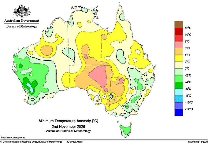
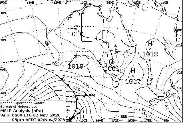
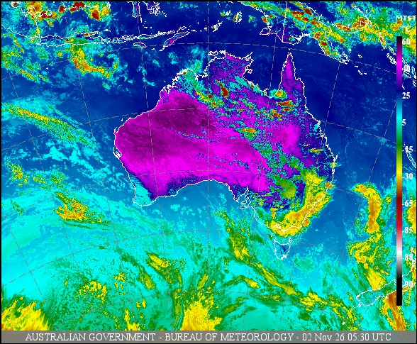
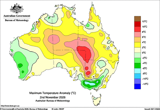
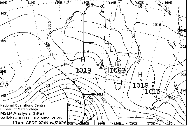
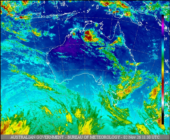
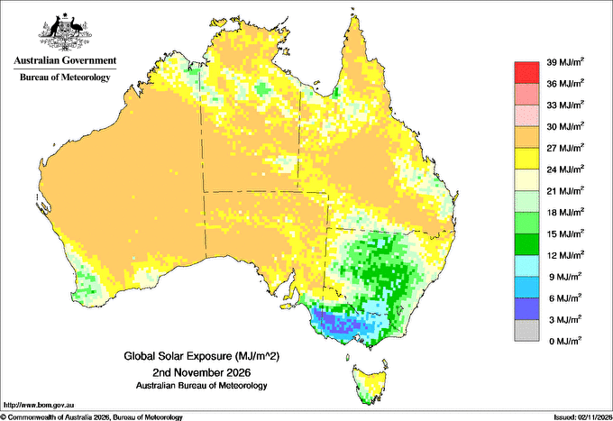
For notes on how to interpret
the data and quality control issues, see Daily Weather Summary Help. Data is as received at 14:22EST, 03/11/2026.
Observations and extremes for Monday 02 NOV 2026
Cities with 2018 populations over 40,000 (QLD, NSW, ACT, VIC) or 20,000 (WA, NT ,SA, TAS)
Max °
C
+/- norm °
C
Min °
C
+/- norm °
C
Grass Min °
C
Rain to 9am mm
Evaporation to 9am mm
Sunshine hours
Wind Run to 9am km (24-hour average km/h)
Maximum Gust km/h / hour of occurrence
GERALDTON AIRPORT
24.2
-4.3
12.0
-2.6
--
0.0
--
--
--
--
PERTH AIRPORT M.O.
22.8
-3.4
14.5
+1.7
--
0.4
--
--
--
--
PERTH METRO
21.8
-5.0
14.8
+0.4
--
0.2
--
--
--
--
BUSSELTON AERO
21.2
-3.9
12.5
+1.8
--
0.0
--
--
--
--
BUNBURY
21.2
-3.4
15.6
+3.5
--
0.0
--
--
--
--
MANDURAH
20.4
-4.6
16.2
+0.6
--
0.0
--
--
--
--
ALBANY AIRPORT
23.7
+2.1
9.3
-1.9
--
2.0
--
--
--
--
KALGOORLIE-BOULDER AIRPORT
29.9
+0.8
12.5
-1.7
--
0.0
--
--
--
--
DARWIN AIRPORT
34.9
+1.5
26.3
+1.0
--
0.0
--
--
--
--
ALICE SPRINGS AIRPORT
40.1
+6.3
24.4
+6.5
--
0.0
--
--
--
--
WHYALLA AERO
26.8
+0.2
15.8
+1.8
--
0.0
--
--
--
--
ADELAIDE (WEST TERRACE / NGAYIRDAPIRA)
25.1
+0.7
15.1
+1.9
--
3.8
--
--
--
--
PARAFIELD AIRPORT
25.7
+0.2
14.4
+1.6
--
7.8
--
--
--
--
ADELAIDE AIRPORT
24.7
--
13.4
--
--
3.8
--
--
--
--
MOUNT GAMBIER AERO
20.2
-0.4
9.0
+0.5
--
0.0
--
--
--
--
CAIRNS AERO
30.7
-0.1
24.3
+1.9
--
0.0
--
--
--
--
TOWNSVILLE AERO
31.2
+0.4
25.4
+2.4
--
0.2
--
--
--
--
MACKAY AERO
31.7
+1.9
23.9
+3.3
--
0.0
--
--
--
--
ROCKHAMPTON AERO
34.2
+2.9
21.5
+1.9
--
0.0
--
--
--
--
BUNDABERG AERO
29.4
+0.8
20.7
+1.8
--
0.2
--
--
--
--
GLADSTONE AIRPORT
30.4
+1.3
23.7
+3.1
--
0.0
--
--
--
--
HERVEY BAY AIRPORT
27.5
-0.7
22.7
+3.5
--
0.0
--
--
--
--
COOLANGATTA
28.9
+2.6
17.1
-1.1
--
2.0
--
--
--
--
BRISBANE AERO
28.6
+1.6
18.1
-0.3
--
0.8
--
--
--
--
SUNSHINE COAST AIRPORT
29.7
+2.5
19.1
+1.1
--
0.0
--
--
--
--
BRISBANE
31.4
+3.1
18.4
-0.4
--
0.8
--
--
--
--
TOOWOOMBA AIRPORT
29.6
+3.3
15.1
+0.3
--
0.2
--
--
--
--
TAMWORTH AIRPORT AWS
28.0
-0.7
11.7
-1.7
--
0.0
--
--
--
--
ARMIDALE AIRPORT AWS
23.6
+0.8
11.1
+1.0
--
2.2
--
--
--
--
COFFS HARBOUR AIRPORT
25.4
-0.5
16.2
-0.6
--
3.6
--
--
--
--
CESSNOCK AIRPORT AWS
27.5
+0.5
14.9
+1.7
--
1.6
--
--
--
--
ORANGE AIRPORT AWS
18.6
-3.1
5.7
-2.7
--
0.0
--
--
--
--
SYDNEY AIRPORT AMO
26.7
+2.5
18.5
+2.9
15
0.0
--
--
--
--
BADGERYS CREEK AWS
27.9
+1.3
14.2
+0.6
--
0.2
--
--
--
--
ALBION PARK (SHELLHARBOUR AIRPORT)
24.3
+0.2
14.5
+0.9
--
0.0
--
--
--
--
CANBERRA AIRPORT
24.3
-0.4
7.9
-1.9
--
0.2
--
--
--
--
WAGGA WAGGA AMO
22.7
-3.2
9.9
-1.1
--
0.0
--
--
--
--
ALBURY AIRPORT AWS
18.6
-7.7
9.4
-2.5
--
0.0
--
--
--
--
MILDURA AIRPORT
34.7
+7.0
16.3
+3.6
--
4.2
--
--
--
--
BENDIGO AIRPORT
15.3
-9.4
9.8
-0.2
--
3.4
--
--
--
--
SHEPPARTON AIRPORT
19.3
-7.0
10.5
-0.4
--
0.0
--
--
--
--
MORWELL (LATROBE VALLEY AIRPORT)
20.6
-1.6
7.1
-2.6
--
0.0
--
--
--
--
MELBOURNE AIRPORT
18.4
-3.7
8.9
-1.6
--
0.2
--
--
--
--
MELBOURNE (OLYMPIC PARK)
19.1
-3.2
12.2
-0.6
--
0.0
--
--
--
--
BREAKWATER (GEELONG RACECOURSE)
17.5
-4.5
10.2
-1.0
--
0.0
--
--
--
--
BALLARAT AERODROME
14.4
-5.3
9.3
+1.4
--
0.2
--
--
--
--
WYNYARD AIRPORT
17.2
-0.9
3.9
-4.4
--
0.0
--
--
--
--
DEVONPORT AIRPORT
16.4
-1.6
4.5
-4.8
--
0.0
--
--
--
--
LAUNCESTON (TI TREE BEND)
21.3
+0.6
6.0
-3.2
--
0.0
--
--
--
--
HOBART (ELLERSLIE ROAD)
20.1
+1.3
9.1
-0.3
--
0.0
--
--
--
--
Max °
C
+/- norm °
C
Min °
C
+/- norm °
C
Grass Min °
C
Rain to 9am mm
Evaporation to 9am mm
Sunshine hours
Wind Run to 9am km
Maximum Gust km/h / hour of occurrence
Hottest for Monday 02 NOV 2026
Highest maximum temperature>
Greatest variation above normal maximum
Highest minimum temperature
Greatest variation above normal minimum
44.8 BIRDSVILLE AIRPORT Channel Country QLD 43.7 BEDOURIE Channel Country QLD 43.6 RABBIT FLAT N Plateau NT 43.6 TELFER AERO Interior WA 43.5 FITZROY CROSSING AERO W Kimberley WA
+8.3 : 44.8 BIRDSVILLE AIRPORT Channel Country QLD +7.9 : 36.9 BROKEN HILL AIRPORT AWS Lower Darling NSW +7.6 : 41.9 MOOMBA AIRPORT NE Pastoral SA +7.6 : 43.1 BALLERA GAS FIELD Far SW QLD +7.4 : 38 POONCARIE MAIL AGENCY Lower Darling NSW
28.4 WYNDHAM AERO N Kimberley WA 28.3 NORMANTON AIRPORT Gulf Country QLD 28.3 CENTURY MINE Gulf Country QLD 28.3 TELFER AERO Interior WA 28.1 TROUGHTON ISLAND N Kimberley WA
+7.6 : 23 ARKAROOLA NE Pastoral SA +6.5 : 24.4 ALICE SPRINGS AIRPORT N Plateau NT +6.3 : 22.7 LEIGH CREEK AIRPORT NE Pastoral SA +6.0 : 13 BOMBALA (THERRY STREET) Goulburn/Monaro NSW +6.0 : 24.7 OODNADATTA AIRPORT NE Pastoral SA +6.0 : 23.8 MARREE AERO NE Pastoral SA
Coldest for Monday 02 NOV 2026
Lowest maximum temperature
Greatest variation below normal maximum
Lowest minimum temperature
Greatest variation below normal minimum
8.0 MOUNT HOTHAM Upper NE VIC 9.2 MOUNT BULLER Upper NE VIC 9.5 FALLS CREEK Upper NE VIC 10.5 KUNANYI (MOUNT WELLINGTON PINNACLE) Southeast TAS 10.9 MOUNT READ W Coast TAS
-9.4 : 15.3 BENDIGO AIRPORT Upper North VIC -9.0 : 15 REDESDALE N Central VIC -8.8 : 17.4 NHILL AERODROME Wimmera N VIC -8.6 : 17.3 HORSHAM AERODROME Wimmera S VIC -8.2 : 19.0 YARRAWONGA Upper North VIC
-0.7 KUNANYI (MOUNT WELLINGTON PINNACLE) Southeast TAS -0.5 LIAWENEE Central Plateau TAS 0.7 BUTLERS GORGE Central Plateau TAS 0.9 MOUNT READ W Coast TAS 1.5 CRESSY (BRUMBYS CREEK) N Coast TAS
-8.3 : 4 KELLERBERRIN Cent Wheatbelt WA -7.4 : 3 EUDUNDA Murray Valley SA -6.8 : 6.4 DALWALLINU Central West WA -6.5 : 5.8 CUNDERDIN AIRFIELD Cent Wheatbelt WA -6.3 : 5 YORK Cent Wheatbelt WA
Wettest
Sunniest &
dullest
Windiest
Highest gusts
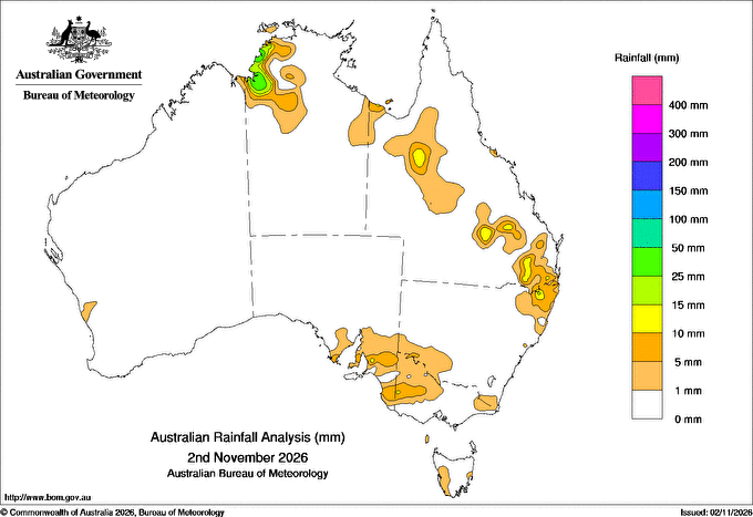
Todays highest rainfall totals for the 24 hours to 9am. It
includes the top 5 totals nationally followed by all reported falls of 50mm or more.
Hours
of sunshine for the 24 hours to midnight.
Highest wind
run totals in kilometres for the 24 hours to 9am (average speed in brackets).
All reported runs >
=25km/h are shown.
Highest wind
gusts in km/h for the 24 hours to midnight followed by the hour in which it occurred.
All stations with gusts >
89km/h are shown.
53.4 CHESTERTON TM Warrego QLD 39.4 KANGAROO FLATS (DEFENCE) Northern Rivers NT 38.4 CHANNEL POINT Northern Rivers NT 33.0 GAYNDAH AIRPORT Wide Bay/Burnett QLD
High rainfall for periods of 6 hours or less from AWS and synoptic reports.
Storm force gusts (>89km/h) and 10-minute mean gales (>62km/h) reported by AWSs. Wind direction and mean windspeed are shown in brackets.
NORTHERN TERRITORY Northern Rivers GROOTE EYLANDT AIRPORT
16.8mm in 12 min to 12:55 84.0mm/h
2.8mm in 2 min to 12:57 84.0mm/h
5.0mm in 3 min to 13:00 100.0mm/h
27.4mm in 1 hr to 13:00 27.4mm/h
5.6mm in 6 min to 13:07 56.0mm/h
40.4mm in 1 hr to 13:30 40.4mm/h
13.2mm in 1 hr to 14:00 13.2mm/h
41.0mm in 3 hr to 15:30 13.7mm/h BRADSHAW - ANGALLARI VALLEY (DEFENCE)
18.2mm in 21 min to 19:51 52.0mm/h
20.4mm in 1 hr to 20:00 20.4mm/h
20.8mm in 1 hr to 20:30 20.8mm/h
21.0mm in 3 hr to 21:30 7.0mm/h QUEENSLAND Gulf Country NORMANTON AIRPORT
10.4mm in 11 min to 11:15 56.7mm/h
10.0mm in 10 min to 11:30 60.0mm/h
25.0mm in 1 hr to 11:30 25.0mm/h
32.0mm in 1 hr to 12:00 32.0mm/h
32.0mm in 3 hr to 12:00 10.7mm/h Northwest CARTERS BORE
10.2mm in 1 hr to 18:30 10.2mm/h Brisbane/SE Coast MARYBOROUGH
2.2mm in 1 min to 18:51 132.0mm/h
15.0mm in 6 min to 18:57 150.0mm/h
22.2mm in 1 hr to 19:00 22.2mm/h
5.6mm in 3 min to 19:04 112.0mm/h
34.4mm in 1 hr to 19:30 34.4mm/h
13.2mm in 1 hr to 20:00 13.2mm/h
36.0mm in 3 hr to 21:00 12.0mm/h NAMBOUR DAFF - HILLSIDE
11.8mm in 1 hr to 15:30 11.8mm/h NEW SOUTH WALES North Coast GRAFTON RESEARCH STN
3.0mm in 2 min to 17:12 90.0mm/h
4.0mm in 2 min to 17:14 120.0mm/h
6.0mm in 6 min to 17:20 60.0mm/h
14.8mm in 1 hr to 17:30 14.8mm/h
16.0mm in 1 hr to 18:00 16.0mm/h
16.0mm in 3 hr to 18:00 5.3mm/h VICTORIA Mallee S HOPETOUN AIRPORT
7.4mm in 7 min to 15:09 63.4mm/h Lower North KERANG AIRPORT
10.6mm in 1 hr to 18:00 10.6mm/h
10.0mm in 1 hr to 18:30 10.0mm/h