 |
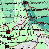
| 200hPa wind analysis shows a strong jetstream
entrance over central southern QLD. COLA |
 |
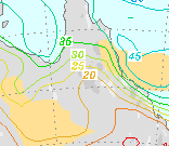
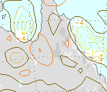
| See the article for interpretation. Above:
850hPa temperature, humidity and wind. Below: Precipitable water
and instability.
Bottom:
700hPa vertical ascent. All at 10am EST today. COLA |
 |
 |
Steady heavy to torrential rain fell for much of today along a 250km strip
of the QLD North Coast. From the Daintree south to Tully,
most raingauges on the coastal plains and eastward-facing mountain
slopes recorded between 100mm and 225mm midnight to midnight as a burst
of colder southern air overrode a small and nearly stationary area
of moist surface air.
Heavy rain began falling to the south and west of Tully late last night,
with 36mm already in the gauge by midnight at Bolinda Estate, 20km
WNW of Tully, and 37 at Abergowrie Bridge, 10km NW of Ingham. Overnight,
the area of rain cleared from around Ingham but extended north across
Cairns to the Daintree. Most recordings in the area for the 24 hours
to 9am were between 20 and 90mm, with the highest reports from flood
warning gauges being 96mm at Jarra Creek Alert, 95 at Bolinda Estate
Alert and 93 at Davidson Creek Alert, all 10 to 20km to the W or NW
of Tully.
Rain fell continuously for the rest of the day, with pulses of torrential
rain in the Cairns area around midday and around Tully/Innisfail later
in the afternoon. Cairns Airport recorded 78mm between 11am and 2pm,
while about 5km SW of Innisfail Tung Oil recorded 91 and nearby Marco
Street a corroborating 80mm between 3 and 6pm. By Midnight this evening,
Jarra Creek Alert had recorded 225mm for the calendar day. See the
Wettest box below and the report for Sunday
20 April for further
details.
The cause of the rain is clear from the accompanying maps. The top right
chart shows the situation at 850hPa or about 1.5km. Buried under the
deep green area of high relative humidity is the QLD North Coast,
with further moisture upstream being fed onto the coast by moderate
ESE winds. The
red isotherms show that a tongue of cooler air overlies the area. The
middle right map confirms deep moisture through the atmosphere with
45mm of precipitable water in suspension in the atmosphere off the
coast, and a buff area showing enhanced instability. The lower right
map measures vertical movement at 700hPa or about 3km; again there
is a bullseye of strong uplift (dotted lines) off the North QLD Coast.
Overlying all of this is the entrance to a moderately intense jetstream
over
central southern QLD (top left), which enhances the uplift in the low
to middle
atmosphere by literally sucking the air up into the accelerating air
aloft. Added to the ample moisture supply and moderate levels of instability
caused by cooler upper air and the jetstream entrance is the topography
of the QLD North Coast. Here, the highest mountains in QLD rise to
over 1,500m only 20 to 30km behind the coast, adding extreme orographic
uplift to the meteorological mix.
The Bureau of Meteorology's map
of the area shows the location of stations mentioned above. |


