Australian Weather News   Site:  Home   Daily Weather Summaries    Search   Feedback   About 
Weather:  Forecasts   Current   Recent & climate   Severe   Know-how   Mobile
 World weather maps    Radar & Lighting   AWS obs   Synoptic obs   Rain & rivers   Daily data    Today's daily summary   DA Page
Full list of charts

HELP!!!

Station location map, information and data:
Australian or Global

WHOLE GLOBE

ALL AUSTRALIA
--Southeastern Australia
--New South Wales
----Sydney area
--Victoria
----Melbourne area
--Tasmania
----Hobart region
--South Australia
----SE South Australia
--Western Australia
----SW Western Australia
--Northern Territory/Queensland
----Northern Territory Top End
----Queensland coast
----SE Queensland

AUSTRALIAN REGION
--Coral and Tasman Seas
--South Pacific Islands
--New Zealand

ALL AFRICA
--NW Africa
--Central and NE Africa
--Southern Africa

ALL ASIA
--Asian Russia
--Middle East
--Central Western Asia
--India
--China
--Japan/Korea
--SE Asia/ Indonesia/Philippines

ALL SOUTH AMERICA
--NW South America
--NE South America
--Southern South America

ALL NORTH AMERICA
--Alaska and Canadian Territories
--Canada - western provinces
--Canada - eastern provinces
--contiguous United States
----Western United States
----Central United States
----NE United States
--Mexico, Central America, Gulf of Mexico, Caribbean

ALL EUROPE
--Western Europe
--Mediterranean
--United Kingdom
--Iberia, France, Low Countries
--Germany to Italy
--Scandinavia, Baltic
--Central Europe - north
--Central Europe - south
--European Russia

OCEANS AND POLES
--North Atlantic Ocean
--South Atlantic Ocean
--Indian Ocean
--North Pacific Ocean
--South Pacific Ocean
--Arctic Ocean
--Antarctica & Southern Ocean

TIMEZONE MAPS
--Current time maps
--Interactive timezone map


AWN synoptic weather chart for
the whole globe (non-polar)
01/01/21: World Weather Maps are no longer being produced due to the considerable overheads involved in their running and maintenance.
Archives
Quick Tips
Area notes
Latest hourly chart
Time now UTC


Updated about 25 minutes past each hour
Because most charts span multiple time zones, all charts use UTC (GMT). Current UTC is at right.

Current times across this chart and in Australia from timeanddate.com
For detailed time zone maps go here or here.
See here for DST exceptions

SAN FRANCISCO
Pacific USA and Canada

NEW YORK
Eastern USA and Canada, Chile, Western Brazil

ROME
Italy
Spain, France
Albania, Serbia

MUMBAI
India
Sri Lanka
Bangladesh

SYDNEY

 
Nominal Time UTC Australian clock time. The charts marked ** are 1 day ahead of UTC. Surface chart one-month archive
Each chart is for the same clock time across Australia. Western Australian observations are 2 hours behind those in eastern Australia (3 hours during daylight saving time).
Date:

01

02

03

04

05

06

07

08

09

10

11

12

13

14

15

16

17

18

19

20

21

22

23

24

25

26

27

28

29

30

31

00 0900 00 00 00 00 00 00 00 00 00 00 00 00 00 00 00 00 00 00 00 00 00 00 00 00 00 00 00 00 00 00 00
03 1200 03 03 03 03 03 03 03 03 03 03 03 03 03 03 03 03 03 03 03 03 03 03 03 03 03 03 03 03 03 03 03
06 1500 06 06 06 06 06 06 06 06 06 06 06 06 06 06 06 06 06 06 06 06 06 06 06 06 06 06 06 06 06 06 06
09 1800 09 09 09 09 09 09 09 09 09 09 09 09 09 09 09 09 09 09 09 09 09 09 09 09 09 09 09 09 09 09 09
12 2100 12 12 12 12 12 12 12 12 12 12 12 12 12 12 12 12 12 12 12 12 12 12 12 12 12 12 12 12 12 12 12
15 0000 ** 15 15 15 15 15 15 15 15 15 15 15 15 15 15 15 15 15 15 15 15 15 15 15 15 15 15 15 15 15 15 15
18 0300 ** 18 18 18 18 18 18 18 18 18 18 18 18 18 18 18 18 18 18 18 18 18 18 18 18 18 18 18 18 18 18 18
21 0600 ** 21 21 21 21 21 21 21 21 21 21 21 21 21 21 21 21 21 21 21 21 21 21 21 21 21 21 21 21 21 21 21
Time UTC Level (hPa/approx altitude in km above msl)

Upper air chart one-month archive
See help for information on upper air charts

Date:

01

02

03

04

05

06

07

08

09

10

11

12

13

14

15

16

17

18

19

20

21

22

23

24

25

26

27

28

29

30

31

Morning radiosonde flights - approx. 00 UTC (9am Australian EST)
00 200/~11.8km 00 00 00 00 00 00 00 00 00 00 00 00 00 00 00 00 00 00 00 00 00 00 00 00 00 00 00 00 00 00 00
00 300/~9.1km 00 00 00 00 00 00 00 00 00 00 00 00 00 00 00 00 00 00 00 00 00 00 00 00 00 00 00 00 00 00 00
00 500/~5.5km 00 00 00 00 00 00 00 00 00 00 00 00 00 00 00 00 00 00 00 00 00 00 00 00 00 00 00 00 00 00 00
00 700/~3.0km 00 00 00 00 00 00 00 00 00 00 00 00 00 00 00 00 00 00 00 00 00 00 00 00 00 00 00 00 00 00 00
00 850/~1.5km 00 00 00 00 00 00 00 00 00 00 00 00 00 00 00 00 00 00 00 00 00 00 00 00 00 00 00 00 00 00 00
Evening radiosonde flights - approx. 12 UTC (9pm Australian EST)
12 200/~11.8km 12 12 12 12 12 12 12 12 12 12 12 12 12 12 12 12 12 12 12 12 12 12 12 12 12 12 12 12 12 12 12
12 300/~9.1km 12 12 12 12 12 12 12 12 12 12 12 12 12 12 12 12 12 12 12 12 12 12 12 12 12 12 12 12 12 12 12
12 500/~5.5km 12 12 12 12 12 12 12 12 12 12 12 12 12 12 12 12 12 12 12 12 12 12 12 12 12 12 12 12 12 12 12
12 700/~3.0km 12 12 12 12 12 12 12 12 12 12 12 12 12 12 12 12 12 12 12 12 12 12 12 12 12 12 12 12 12 12 12
12 850/~1.5km 12 12 12 12 12 12 12 12 12 12 12 12 12 12 12 12 12 12 12 12 12 12 12 12 12 12 12 12 12 12 12
 
Quick Tips: (for full information, visit HELP!!!)  
  • Check the chart is current. For the latest hourly chart, the date/time in the "generated" box in the top left corner of the chart should be at most 90 minutes behind the "Time Now UTC" shown next to the Latest hourly chart link.
  • All charts open in new windows. You can click between charts to make comparisons. AWN's charts are large, and most browsers in their default settings will resize the image to fit the screen. Click on any part of the chart to enlarge it.
  • For one-click access to latest chart for an area , click the in the full list of charts.
  • A rough guide to the main time zones across the chart is given in the bar under the Latest hourly chart link and there's more information in Area Notes below. This map shows all world timezones and the time in them now - click anywhere for a more detailed map. This map shows where daylight saving time is used and now operating (yellow), used and not operating (green) and not used (grey).
  • Surface charts show pressure isobars in red, temperature isotherms in green (but 0° in dark blue, +30° in orange, -30° in purple), and wind streamlines in grey. Light green shading shows areas with relative humidity above 80%, light yellow below 20%. Exceptions are noted in the Area Notes below.
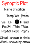
  • Observations for each station are plotted around its location as shown in the observation rose at right. The location is marked by a circle which contains a symbol for amount of cloud or "+" for an AWS not observing cloud. A wind shaft and feathers show the direction and speed of wind blowing into the station. The sample plot at right may help reading clockwise from the top. The station name is Eskdalemuir (only the first 10 letters are given), and the Weather symbol (3 dots) shows continuous moderate rain is falling. The barometer is 998.3 hPa, and the symbol showing barometer trend indicates it fell a bit then rose1.2 hPa in the past 3 hours. 3.0mm of rain has fallen in the past 12 hours, while in the past 24 hours the minimum temperature has been 9 and the rainfall 13.0mm. Currently, visibility is 30km, the dew point is 9 and the temperature 10.4. Learn more in the help section on synoptic plots.
  • More information on the observation practices in different countries will be found in Area Notes below.


Area Notes:

No notes for this area yet.