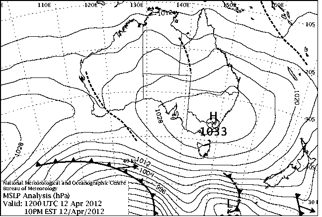
|
For notes on how to interpret
the data and quality control issues, see Daily Weather Summary Help.
**S** and **W** precede data flagged by the Bureau as suspicious or wrong
Data is as received at 21:20EST, 19/04/2013.
|
|
| |
Max
°
C |
+/- norm
°
C |
Min
°
C |
+/- norm
°
C |
Grass Min
°
C |
Rain to 9am mm |
Evaporation to 9am mm |
Sunshine hours |
Wind Run to 9am km (24-hour average km/h) |
Maximum Gust km/h / hour of occurrence |
| GERALDTON AIRPORT COMPARISON |
32.6 |
+4.9 |
12.8 |
-2.6 |
-- |
0.0 |
-- |
-- |
269 (11.2) |
31/13 |
| PERTH AIRPORT |
30.4 |
+4.9 |
12.7 |
-0.2 |
10.2 |
0.0 |
6.0 |
5.3 |
272 (11.3) |
28/19 |
| ALBANY AIRPORT COMPARISON |
-- |
-- |
-- |
-- |
-- |
-- |
-- |
-- |
-- |
-- |
| BUNBURY |
26.4 |
+2.3 |
17.4 |
+5.8 |
-- |
0.0 |
-- |
-- |
236 ( 9.8) |
31/19 |
| MANDURAH |
26.9 |
+3.1 |
19.1 |
+3.6 |
-- |
0.0 |
-- |
-- |
190 ( 7.9) |
26/15 |
| DARWIN AIRPORT |
32.9 |
+0.2 |
23.9 |
-0.1 |
23.1 |
0.0 |
8.6 |
9.4 |
429 (17.9) |
44/10 |
| ALICE SPRINGS AIRPORT |
20.5 |
-7.7 |
11.8 |
-0.8 |
10.8 |
0.0 |
9.4 |
1.2 |
306 (12.8) |
-- |
| WHYALLA AERO |
25.5 |
+1.8 |
6.3 |
-5.3 |
-- |
0.0 |
12.0 |
-- |
252 (10.5) |
31/11 |
| ADELAIDE (KENT TOWN) |
24.1 |
+1.5 |
8.2 |
-4.2 |
-- |
0.0 |
3.2 |
10.9 |
113 ( 4.7) |
28/13 |
| MOUNT GAMBIER AERO |
23.7 |
+4.3 |
2.7 |
-6.0 |
1.3 |
0.0 |
3.2 |
9.5 |
214 ( 8.9) |
31/11 |
| MOUNT ISA AERO |
30.9 |
-0.9 |
17.5 |
-1.0 |
14.6 |
0.0 |
7.2 |
-- |
365 (15.2) |
39/09 |
| CAIRNS AERO |
25.4 |
-3.8 |
22.1 |
+0.5 |
20.9 |
46.4 |
6.8 |
0.7 |
549 (22.9) |
59/21 |
| TOWNSVILLE AERO |
29.7 |
+0.1 |
23.2 |
+2.6 |
21.0 |
0.0 |
11.4 |
5.5 |
573 (23.9) |
57/11 |
| MACKAY M.O |
25.8 |
-0.9 |
21.7 |
+1.6 |
-- |
0.2 |
-- |
-- |
730 (30.4) |
61/04 |
| ROCKHAMPTON AERO |
27.3 |
-1.5 |
16.6 |
-1.3 |
15.0 |
0.0 |
6.8 |
-- |
416 (17.3) |
48/13 |
| BUNDABERG AERO |
26.0 |
-1.4 |
16.6 |
-1.0 |
-- |
0.0 |
-- |
-- |
515 (21.5) |
55/15 |
| NAMBOUR DPI |
-- |
-- |
-- |
-- |
-- |
-- |
-- |
-- |
-- |
-- |
| COOLANGATTA |
24.4 |
-1.0 |
15.1 |
-1.9 |
-- |
0.8 |
-- |
-- |
452 (18.8) |
52/12 |
| BRISBANE AERO |
24.8 |
-1.2 |
13.7 |
-2.6 |
12.6 |
0.0 |
6.2 |
8.6 |
414 (17.3) |
44/11 |
| TOOWOOMBA AIRPORT |
20.3 |
-3.0 |
9.1 |
-4.3 |
-- |
0.0 |
-- |
-- |
512 (21.3) |
54/10 |
| GUNNEDAH RESOURCE CENTRE |
23.6 |
-1.6 |
11.1 |
-1.7 |
7.4 |
0.0 |
4.4 |
-- |
320 (13.3) |
-- |
| COFFS HARBOUR MO |
22.7 |
-1.3 |
14.5 |
-0.7 |
11.3 |
3.8 |
4.4 |
6.8 |
584 (24.3) |
54/12 |
| PORT MACQUARIE AIRPORT AWS |
23.6 |
-0.5 |
12.4 |
-1.3 |
-- |
2.2 |
-- |
-- |
321 (13.4) |
41/12 |
| WILLIAMTOWN RAAF |
21.9 |
-1.7 |
11.4 |
-1.8 |
10.3 |
9.8 |
1.8 |
-- |
386 (16.1) |
-- |
| GOSFORD (NARARA RESEARCH STATION) AWS |
19.2 |
-4.4 |
12.1 |
+0.2 |
-- |
3.8 |
-- |
-- |
110 ( 4.6) |
21/04 |
| ORANGE AGRICULTURAL INSTITUTE |
17.5 |
-0.9 |
3.8 |
-3.4 |
-2.0 |
0.0 |
2.4 |
10.2 |
-- |
-- |
| DUBBO AIRPORT AWS |
24.1 |
-0.4 |
4.7 |
-5.5 |
-- |
0.0 |
-- |
-- |
270 (11.3) |
48/14 |
| SYDNEY AIRPORT AMO |
20.6 |
-2.3 |
13.7 |
-0.5 |
11.4 |
3.8 |
2.8 |
10.1 |
685 (28.5) |
43/10 |
| RICHMOND RAAF |
22.9 |
-0.9 |
10.5 |
-0.9 |
-- |
0.0 |
-- |
-- |
184 ( 7.7) |
30/01 |
| BELLAMBI AWS |
19.9 |
-2.2 |
13.9 |
-1.6 |
-- |
11.8 |
-- |
-- |
529 (22.0) |
34/09 |
| CANBERRA AIRPORT |
-- |
-- |
-- |
-- |
-- |
-- |
-- |
-- |
-- |
-- |
| WAGGA WAGGA AMO |
22.1 |
-0.4 |
3.6 |
-5.5 |
0.1 |
0.0 |
3.0 |
11.2 |
153 ( 6.4) |
22/15 |
| ALBURY AIRPORT AWS |
21.7 |
-0.6 |
4.3 |
-3.8 |
-- |
0.0 |
-- |
-- |
59 ( 2.5) |
22/14 |
| MILDURA AIRPORT |
24.8 |
+1.3 |
2.8 |
-7.3 |
-1.2 |
0.0 |
3.8 |
10.5 |
237 ( 9.9) |
24/11 |
| TATURA INST SUSTAINABLE AG |
21.6 |
0.0 |
2.0 |
-6.2 |
-1.5 |
0.0 |
2.6 |
-- |
198 ( 8.3) |
24/12 |
| BENDIGO AIRPORT |
21.8 |
+0.6 |
3.7 |
-3.9 |
-- |
0.0 |
-- |
-- |
240 (10.0) |
�
24/14 |
| MELBOURNE REGIONAL OFFICE |
23.2 |
+2.9 |
8.2 |
-2.6 |
6.2 |
0.0 |
2.6 |
-- |
-- |
-- |
| BALLARAT AERODROME |
20.8 |
+3.2 |
1.6 |
-5.9 |
-- |
0.0 |
-- |
-- |
325 (13.5) |
24/13 |
| LAUNCESTON (TI TREE BEND) |
19.4 |
+0.5 |
6.0 |
-1.6 |
-- |
0.0 |
-- |
-- |
106 ( 4.4) |
34/16 |
| HOBART AIRPORT |
22.0 |
+3.9 |
11.6 |
+2.8 |
8.3 |
0.0 |
4.0 |
10.3 |
480 (20.0) |
43/05 |
| |
Max
°
C |
+/- norm
°
C |
Min
°
C |
+/- norm
°
C |
Grass Min
°
C |
Rain to 9am mm |
Evaporation to 9am mm |
Sunshine hours |
Wind Run to 9am km |
Maximum Gust km/h / hour of occurrence |
|
| Hottest |
| Highest maximum temperature> | Greatest variation above normal maximum |
Highest minimum temperature | Greatest variation above normal minimum |
36.5 SHARK BAY AIRPORT W Gascoyne WA
36.0 MARDIE W Pilbara WA
36.0 KATHERINE AVIATION MUSEUM N Rivers NT
35.4 DENHAM W Gascoyne WA
|
+8.8 : 32.7 LAKE GRACE COMPARISON Cent Wheatbelt WA
+8.4 : 32.4 PINGELLY Cent Wheatbelt WA
+8.2 : 31.2 NARROGIN Cent Wheatbelt WA
+8.1 : 32.2 NEWDEGATE RESEARCH STATION Cent Wheatbelt WA
|
27.0 TROUGHTON ISLAND N Kimberley WA
27.0 NORTH EAST ISLAND Islands ISL
26.7 VARANUS ISLAND Islands ISL
26.5 HORN ISLAND N Peninsula QLD
26.2 COCONUT ISLAND N Peninsula QLD
|
+10.0 : 18.4 BRIDGETOWN COMPARISON Lower West WA
+8.8 : 17.8 BRIDGETOWN Lower West WA
+8.1 : 16.8 JARRAHWOOD Lower West WA
+6.9 : 17.3 DONNYBROOK Lower West WA
+6.9 : 17.7 WITCHCLIFFE Lower West WA
|
| Coldest |
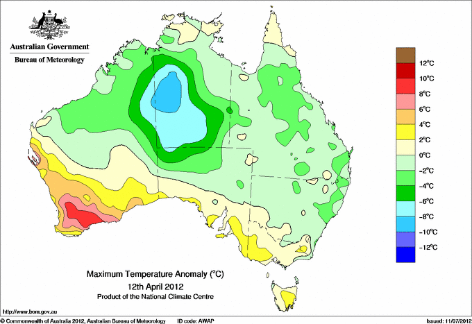
| Lowest maximum temperature | Greatest variation below normal maximum |
Lowest minimum temperature | Greatest variation below normal minimum |
7.3 MOUNT READ W Coast TAS
10.3 HARTZ MOUNTAIN (KEOGHS PIMPLE) Southeast TAS
10.4 MOUNT HOTHAM Upper NE VIC
10.7 MOUNT BAW BAW W Gippsland VIC
10.9 MOUNT BULLER Upper NE VIC
|
-14.7 : 17.3 PAPUNYA N Plateau NT
-12.2 : 18.3 TERRITORY GRAPE FARM N Plateau NT
-10.1 : 20.0 YUENDUMU N Plateau NT
-9.7 : 24.2 RABBIT FLAT N Plateau NT
-8.9 : 24.9 LAJAMANU N Rivers NT
|
-7.0 CHARLOTTE PASS (KOSCIUSKO CHALET) Snowy Mtns NSW
-3.6 COOMA AIRPORT AWS Goulburn/Monaro NSW
-3.0 PERISHER VALLEY AWS Snowy Mtns NSW
-2.5 COOMA VISITORS CENTRE Goulburn/Monaro NSW
-2.5 THREDBO VILLAGE Snowy Mtns NSW
|
-9.2 : 4.5 KULGERA N Plateau NT
-8.5 : 1.0 BURRINJUCK DAM SW Slopes N NSW
-8.3 : -0.1 GLUEPOT RESERVE (GLUEPOT) Northeast SA
-7.8 : 9.6 NEWMAN AERO E Gascoyne WA
-7.8 : 1.0 YUNTA AIRSTRIP Northeast SA
-7.8 : 1.0 RENMARK AERO Murray Valley SA
|
|
Sunniest &
dullest |
Windiest |
Highest gusts |
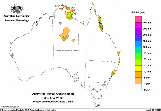
Todays highest rainfall totals for the 24 hours to 9am. It
includes the top 5 totals nationally followed by all reported falls of 50mm or more. |
Highest
and lowest recordings of hours of sunshine for the 24 hours to midnight. |
Highest wind
run totals in kilometres for the 24 hours to 9am (average speed in brackets).
All reported runs >
=25km/h are shown. |
Highest wind
gusts in km/h for the 24 hours to midnight followed by the hour in which it occurred.
All stations with gusts >
89km/h are shown. |
86.0 TOPAZ N Coast--Barron QLD
76.0 TULLY SUGAR MILL N Coast--Herbert QLD
73.6 BELMONT WWTP Hunter Valley NSW
70.0 BELLENDEN KER BOTTOM STN N Coast--Barron QLD
69.0 DEERAL N Coast--Barron QLD
QUEENSLAND
N Coast--Barron
86.0 TOPAZ
70.0 BELLENDEN KER BOTTOM STN
69.0 DEERAL
67.0 KURANDA RAILWAY STATION
66.0 DAINTREE VILLAGE
64.0 TOPAZ ALERT
64.0 MT SOPHIA
60.0 TREE HOUSE CREEK
59.4 WHYANBEEL VALLEY
57.0 REEF PARK
56.0 CAIRNS SEVERIN ST
55.0 HAPPY VALLEY
54.0 BABINDA POST OFFICE
51.2 WHITE CLIFF POINT
N Coast--Herbert
76.0 TULLY SUGAR MILL
53.0 NERADA ALERT
NEW SOUTH WALES
Hunter Valley
73.6 BELMONT WWTP
54.0 NEWCASTLE (BLACKSMITHS)
|
11.8 WOOMERA AERODROME NW Pastoral SA
11.4 GILES METEOROLOGICAL OFFICE Interior WA
11.3 BROOME AIRPORT W Kimberley WA
11.3 WEIPA AERO N Peninsula QLD
11.2 WAGGA WAGGA AMO SW Slopes S NSW
.....
1.7 WALKAMIN RESEARCH STATION N Coast--Barron QLD
1.2 ALICE SPRINGS AIRPORT N Plateau NT
0.9 STRATHGORDON VILLAGE W Coast TAS
0.7 CAIRNS AERO N Coast--Barron QLD
0.0 LOXTON RESEARCH CENTRE Murray Valley SA
|
1573 (65.5) MAATSUYKER ISLAND LIGHTHOUSE Southeast TAS
1361 (56.7) HARTZ MOUNTAIN (KEOGHS PIMPLE) Southeast TAS
1265 (52.7) DOUBLE ISLAND POINT LIGHTHOUSE Brisbane/SE Coast QLD
1248 (52.0) HAMILTON ISLAND AIRPORT Central Coast E QLD
1141 (47.5) RUNDLE ISLAND Wide Bay/Burnett QLD
1123 (46.8) CAPE MORETON LIGHTHOUSE Brisbane/SE Coast QLD
974 (40.6) LADY ELLIOT ISLAND Wide Bay/Burnett QLD
972 (40.5) HERON ISLAND RES STN Wide Bay/Burnett QLD
960 (40.0) LOW ISLES LIGHTHOUSE N Coast--Barron QLD
907 (37.8) WILLIS ISLAND Islands ISL
878 (36.6) BYRON BAY (CAPE BYRON AWS) North Coast NSW
817 (34.0) MURRURUNDI GAP AWS Hunter Valley NSW
798 (33.3) GOLD COAST SEAWAY Brisbane/SE Coast QLD
797 (33.2) MACKAY AERO Central Coast E QLD
797 (33.2) MOUNT WELLINGTON Southeast TAS
772 (32.2) CENTRE ISLAND N Rivers NT
761 (31.7) VARANUS ISLAND Islands ISL
753 (31.4) HOGAN ISLAND Islands ISL
730 (30.4) MACKAY M.O Central Coast E QLD
685 (28.5) SUNSHINE COAST AIRPORT Brisbane/SE Coast QLD
685 (28.5) SYDNEY AIRPORT AMO Sydney--east NSW
684 (28.5) CAPE GRIM BAPS (COMPARISON) N Coast TAS
682 (28.4) SCOTTS PEAK DAM W Coast TAS
666 (27.8) MCCLUER ISLAND N Rivers NT
654 (27.3) CAPE BRUNY (CAPE BRUNY) Southeast TAS
644 (26.8) GABO ISLAND LIGHTHOUSE E Gippsland VIC
637 (26.5) WILSONS PROMONTORY LIGHTHOUSE W Gippsland VIC
617 (25.7) NORFOLK ISLAND AERO Islands ISL
614 (25.6) PROSERPINE AIRPORT Central Coast E QLD
610 (25.4) EVANS HEAD RAAF BOMBING RANGE AWS North Coast NSW
|
122/17 HARTZ MOUNTAIN (KEOGHS PIMPLE) Southeast TAS
98/15 MAATSUYKER ISLAND LIGHTHOUSE Southeast TAS
91/19 HAMILTON ISLAND AIRPORT Central Coast E QLD
91/20 MOUNT WELLINGTON Southeast TAS
85/04 CAPE MORETON LIGHTHOUSE Brisbane/SE Coast QLD
85/17 DOUBLE ISLAND POINT LIGHTHOUSE Brisbane/SE Coast QLD
|
�