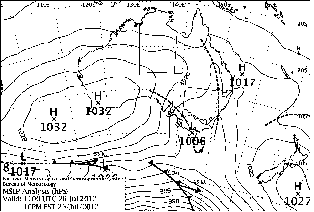
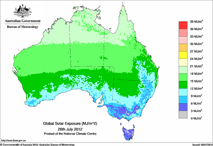
|
For notes on how to interpret
the data and quality control issues, see Daily Weather Summary Help.
**S** and **W** precede data flagged by the Bureau as suspicious or wrong
Data is as received at 02:46EST, 20/04/2013.
|
|
| |
Max
°
C |
+/- norm
°
C |
Min
°
C |
+/- norm
°
C |
Grass Min
°
C |
Rain to 9am mm |
Evaporation to 9am mm |
Sunshine hours |
Wind Run to 9am km (24-hour average km/h) |
Maximum Gust km/h / hour of occurrence |
| GERALDTON AIRPORT COMPARISON |
17.9 |
-1.6 |
3.9 |
-5.5 |
-- |
0.0 |
-- |
-- |
301 (12.5) |
35/10 |
| PERTH AIRPORT |
19.2 |
+1.3 |
0.5 |
-7.5 |
-1.0 |
0.0 |
1.6 |
7.8 |
210 ( 8.8) |
35/10 |
| ALBANY AIRPORT COMPARISON |
16.5 |
+0.7 |
7.2 |
-0.3 |
-- |
4.0 |
-- |
-- |
159 ( 6.6) |
21/13 |
| BUNBURY |
16.7 |
-0.5 |
2.1 |
-5.0 |
-- |
0.4 |
-- |
-- |
91 ( 3.8) |
17/14 |
| MANDURAH |
17.5 |
+0.1 |
6.4 |
-4.3 |
-- |
0.4 |
-- |
-- |
90 ( 3.8) |
17/16 |
| DARWIN AIRPORT |
30.4 |
-0.1 |
18.2 |
-1.1 |
17.7 |
0.0 |
3.8 |
9.8 |
273 (11.4) |
28/13 |
| ALICE SPRINGS AIRPORT |
16.8 |
-2.9 |
2.2 |
-1.9 |
-0.5 |
0.0 |
6.6 |
10.2 |
295 (12.3) |
31/13 |
| WHYALLA AERO |
16.9 |
0.0 |
5.8 |
+0.6 |
-- |
0.0 |
2.6 |
-- |
465 (19.4) |
37/15 |
| ADELAIDE (KENT TOWN) |
14.6 |
-0.7 |
10.0 |
+2.5 |
-- |
3.4 |
1.6 |
-- |
476 (19.8) |
46/13 |
| MOUNT GAMBIER AERO |
14.1 |
+0.9 |
7.7 |
+2.5 |
5.9 |
6.4 |
1.8 |
8.0 |
526 (21.9) |
44/11 |
| MOUNT ISA AERO |
25.2 |
+0.5 |
7.6 |
-1.0 |
6.3 |
0.0 |
5.0 |
-- |
213 ( 8.9) |
44/15 |
| CAIRNS AERO |
26.9 |
+1.2 |
16.3 |
-0.7 |
13.8 |
0.0 |
4.8 |
10.3 |
352 (14.7) |
30/10 |
| TOWNSVILLE AERO |
24.3 |
-0.8 |
14.9 |
+1.3 |
11.4 |
0.0 |
5.4 |
9.9 |
256 (10.7) |
34/14 |
| MACKAY M.O |
20.7 |
-0.6 |
14.4 |
+1.5 |
-- |
0.2 |
-- |
9.9 |
305 (12.7) |
21/12 |
| ROCKHAMPTON AERO |
24.3 |
+1.2 |
11.9 |
+2.4 |
9.0 |
0.0 |
4.0 |
-- |
230 ( 9.6) |
24/10 |
| BUNDABERG AERO |
23.0 |
+1.0 |
9.4 |
-0.8 |
-- |
0.0 |
-- |
-- |
275 (11.5) |
24/15 |
| COOLANGATTA |
20.9 |
+0.4 |
11.6 |
+1.7 |
-- |
0.0 |
-- |
-- |
219 ( 9.1) |
31/14 |
| BRISBANE AERO |
20.2 |
-0.7 |
12.2 |
+3.3 |
10.1 |
0.0 |
2.2 |
6.4 |
267 (11.1) |
22/05 |
| TOOWOOMBA AIRPORT |
17.9 |
+1.4 |
9.4 |
+3.0 |
-- |
0.0 |
-- |
-- |
438 (18.3) |
34/00 |
| GUNNEDAH RESOURCE CENTRE |
17.4 |
+1.3 |
7.3 |
+2.6 |
3.4 |
0.0 |
2.0 |
-- |
41 ( 1.7) |
-- |
| COFFS HARBOUR MO |
21.8 |
+3.1 |
9.0 |
+1.4 |
6.0 |
0.0 |
2.4 |
-- |
268 (11.2) |
34/13 |
| PORT MACQUARIE AIRPORT AWS |
20.7 |
+2.0 |
6.9 |
+0.5 |
-- |
0.0 |
-- |
-- |
100 ( 4.2) |
31/16 |
| WILLIAMTOWN RAAF |
19.8 |
+2.8 |
5.3 |
-1.1 |
3.9 |
0.0 |
1.6 |
-- |
173 ( 7.2) |
31/22 |
| GOSFORD (NARARA RESEARCH STATION) AWS |
18.9 |
+1.4 |
5.9 |
+1.2 |
-- |
0.2 |
-- |
-- |
37 ( 1.5) |
22/21 |
| ORANGE AGRICULTURAL INSTITUTE |
13.2 |
+3.8 |
-0.8 |
-2.3 |
-1.0 |
1.4 |
1.6 |
7.2 |
-- |
-- |
| DUBBO AIRPORT AWS |
20.1 |
+4.9 |
7.8 |
+4.8 |
-- |
0.0 |
-- |
-- |
226 ( 9.4) |
44/11 |
| SYDNEY AIRPORT AMO |
20.0 |
+3.0 |
9.7 |
+2.6 |
6.7 |
0.0 |
3.8 |
3.9 |
354 (14.8) |
34/18 |
| RICHMOND RAAF |
20.4 |
+3.0 |
6.6 |
+3.0 |
-- |
0.0 |
-- |
-- |
143 ( 6.0) |
39/12 |
| BELLAMBI AWS |
18.6 |
+1.8 |
13.0 |
+3.0 |
-- |
0.0 |
-- |
-- |
410 (17.1) |
54/17 |
| WAGGA WAGGA AMO |
14.6 |
+1.9 |
7.5 |
+4.8 |
6.3 |
3.2 |
1.2 |
5.7 |
273 (11.4) |
39/02 |
| ALBURY AIRPORT AWS |
14.8 |
+1.8 |
7.0 |
+3.9 |
-- |
2.4 |
-- |
-- |
185 ( 7.7) |
37/01 |
| MILDURA AIRPORT |
16.3 |
+1.0 |
5.3 |
+1.0 |
2.8 |
1.2 |
1.6 |
8.3 |
348 (14.5) |
44/13 |
| TATURA INST SUSTAINABLE AG |
10.2 |
-2.8 |
5.1 |
+2.2 |
1.0 |
6.4 |
-- |
-- |
330 (13.8) |
31/10 |
| BENDIGO AIRPORT |
9.8 |
-2.7 |
6.4 |
+3.9 |
-- |
11.2 |
-- |
-- |
349 (14.5) |
39/14 |
| MELBOURNE REGIONAL OFFICE |
13.3 |
-0.2 |
9.3 |
+3.3 |
7.2 |
5.0 |
1.8 |
-- |
-- |
-- |
| BALLARAT AERODROME |
10.1 |
+0.1 |
5.3 |
+2.1 |
-- |
2.4 |
-- |
-- |
778 (32.4) |
�
54/10 |
| LAUNCESTON (TI TREE BEND) |
12.9 |
+0.3 |
6.2 |
+4.0 |
-- |
0.0 |
-- |
-- |
91 ( 3.8) |
17/13 |
| HOBART AIRPORT |
11.7 |
-0.7 |
4.4 |
+0.3 |
3.1 |
0.0 |
0.4 |
1.0 |
228 ( 9.5) |
24/15 |
| |
Max
°
C |
+/- norm
°
C |
Min
°
C |
+/- norm
°
C |
Grass Min
°
C |
Rain to 9am mm |
Evaporation to 9am mm |
Sunshine hours |
Wind Run to 9am km |
Maximum Gust km/h / hour of occurrence |
|
| Hottest |
| Highest maximum temperature> | Greatest variation above normal maximum |
Highest minimum temperature | Greatest variation above normal minimum |
34.4 BRADSHAW N Rivers NT
34.3 DOUGLAS RIVER N Rivers NT
33.9 TIMBER CREEK N Rivers NT
33.8 WYNDHAM AERO N Kimberley WA
33.7 KALUMBURU N Kimberley WA
33.7 BULMAN AWS N Rivers NT
|
+5.5 : 23.9 WALGETT AIRPORT AWS NW Plains W NSW
+4.9 : 20.1 DUBBO AIRPORT AWS CW Slopes S NSW
+4.8 : 20.0 WELLINGTON (AGROWPLOW) CW Slopes S NSW
+4.6 : 20.0 TRANGIE RESEARCH STATION AWS CW Plains N NSW
+4.4 : 15.4 BOMBALA (THERRY STREET) Goulburn/Monaro NSW
+4.4 : 14.5 TARALGA POST OFFICE Goulburn/Monaro NSW
+4.4 : 10.4 HARTZ MOUNTAIN (KEOGHS PIMPLE) Southeast TAS
|
26.3 COCOS ISLAND AIRPORT Islands ISL
23.9 COCONUT ISLAND N Peninsula QLD
23.8 HORN ISLAND N Peninsula QLD
23.7 MCCLUER ISLAND N Rivers NT
23.2 CAPE WESSEL Islands ISL
|
+6.8 : 10.9 COLLARENEBRI (ALBERT ST) Upper Darling NSW
+6.6 : 10.0 WYNYARD AIRPORT N Coast TAS
+6.4 : 8.6 BARADINE FORESTRY NW Plains E NSW
+6.1 : 8.9 CONDOBOLIN AG RESEARCH STN CW Plains S NSW
+6.0 : 9.4 COONAMBLE AIRPORT AWS CW Plains N NSW
+6.0 : 8.9 QUANDIALLA POST OFFICE SW Slopes N NSW
|
| Coldest |
| Lowest maximum temperature | Greatest variation below normal maximum |
Lowest minimum temperature | Greatest variation below normal minimum |
-1.7 MOUNT HOTHAM Upper NE VIC
-0.6 THREDBO AWS Snowy Mtns NSW
-0.3 MOUNT BULLER Upper NE VIC
-0.3 FALLS CREEK Upper NE VIC
0.3 MOUNT BAW BAW W Gippsland VIC
|
-6.1 : 5.5 OUSE FIRE STATION Derwent Valley TAS
-5.5 : 16.2 WATARRKA N Plateau NT
-4.4 : 6.7 BUSHY PARK (BUSHY PARK ESTATES) Derwent Valley TAS
-4.1 : 21.2 TELFER AERO Interior WA
-4.0 : 17.9 JERVOIS N Plateau NT
-4.0 : 14.2 NULLARBOR W Agricultural SA
|
-2.3 CURTIN SPRINGS N Plateau NT
-2.2 WOOLBROOK (DANGLEMAH ROAD) NW Slopes S NSW
-2.2 MOUNT BULLER Upper NE VIC
-1.9 SOUTHERN CROSS AIRFIELD Goldfields WA
-1.9 MOUNT HOTHAM Upper NE VIC
-1.9 BUTLERS GORGE Central Plateau TAS
|
-8.5 : 0.0 PEARCE RAAF Lower West WA
-7.8 : -1.5 GINGIN AERO Lower West WA
-7.5 : 0.5 PERTH AIRPORT Lower West WA
-7.2 : -1.5 WARBURTON AIRFIELD Interior WA
-7.2 : 1.0 MEDINA RESEARCH CENTRE Lower West WA
|
|
Sunniest &
dullest |
Windiest |
Highest gusts |
Todays highest rainfall totals for the 24 hours to 9am. It
includes the top 5 totals nationally followed by all reported falls of 50mm or more. |
Highest
and lowest recordings of hours of sunshine for the 24 hours to midnight. |
Highest wind
run totals in kilometres for the 24 hours to 9am (average speed in brackets).
All reported runs >
=25km/h are shown. |
Highest wind
gusts in km/h for the 24 hours to midnight followed by the hour in which it occurred.
All stations with gusts >
89km/h are shown. |
38.0 ECHUNGA GOLF COURSE Adelaide/Lofty SA
31.4 ECHUNGA Adelaide/Lofty SA
30.2 BRADBURY (HOULGRAVES) Adelaide/Lofty SA
28.2 YUNDI (MUNDAWORA) Adelaide/Lofty SA
27.0 LONGWOOD Adelaide/Lofty SA
|
10.9 BROOME AIRPORT W Kimberley WA
10.9 TENNANT CREEK AIRPORT N Plateau NT
10.8 GILES METEOROLOGICAL OFFICE Interior WA
10.7 RABBIT FLAT N Plateau NT
10.3 CAIRNS AERO N Coast--Barron QLD
.....
1.0 BICHENO (COUNCIL DEPOT) E Coast TAS
1.0 HOBART AIRPORT Southeast TAS
0.9 LAKE LEAKE (ELIZABETH RIVER) E Coast TAS
0.7 STRATHGORDON VILLAGE W Coast TAS
0.2 LAKE EILDON N Central VIC
|
1366 (56.9) NEPTUNE ISLAND W Agricultural SA
1099 (45.8) MOUNT BULLER Upper NE VIC
1055 (44.0) CAPE BORDA Yorke Pen/Kanga Is SA
1036 (43.2) FALLS CREEK Upper NE VIC
990 (41.3) THREDBO AWS Snowy Mtns NSW
946 (39.4) GRAMPIANS (MOUNT WILLIAM) Wimmera S VIC
938 (39.1) CAPE WILLOUGHBY Yorke Pen/Kanga Is SA
910 (37.9) CAPE JAFFA (THE LIMESTONE) Lower SE SA
890 (37.1) STENHOUSE BAY Yorke Pen/Kanga Is SA
884 (36.8) MOUNT CRAWFORD (MT CRAWFORD AWS) Adelaide/Lofty SA
882 (36.8) MOUNT READ W Coast TAS
840 (35.0) MINLATON AERO Yorke Pen/Kanga Is SA
799 (33.3) ADELAIDE AIRPORT Adelaide/Lofty SA
785 (32.7) WALLAN (KILMORE GAP) N Central VIC
778 (32.4) BALLARAT AERODROME Western Plains VIC
775 (32.3) EDITHBURGH Yorke Pen/Kanga Is SA
762 (31.8) NURIOOTPA VITICULTURAL Adelaide/Lofty SA
746 (31.1) PARNDANA CFS AWS Yorke Pen/Kanga Is SA
731 (30.5) NORTH ISLAND Central West WA
724 (30.2) PARAWA (SECOND VALLEY FOREST AWS) Adelaide/Lofty SA
698 (29.1) KADINA AWS Yorke Pen/Kanga Is SA
694 (28.9) COLAC (MOUNT GELLIBRAND) W Coast VIC
684 (28.5) NOARLUNGA Adelaide/Lofty SA
684 (28.5) STRATHALBYN RACECOURSE Murray Valley SA
682 (28.4) ROBE AIRFIELD Lower SE SA
678 (28.3) COULTA (COLES POINT) W Agricultural SA
678 (28.3) COCOS ISLAND AIRPORT Islands ISL
674 (28.1) WILLIS ISLAND Islands ISL
647 (27.0) KEITH (MUNKORA) Mallee/Upper SE SA
645 (26.9) EDINBURGH RAAF Adelaide/Lofty SA
638 (26.6) CAPE GRIM N Coast TAS
632 (26.3) KUITPO FOREST RESERVE Adelaide/Lofty SA
630 (26.3) LAMEROO (AUSTIN PLAINS) Mallee/Upper SE SA
626 (26.1) KINGSCOTE AERO Yorke Pen/Kanga Is SA
621 (25.9) ROSEWORTHY AWS Adelaide/Lofty SA
607 (25.3) CARNARVON AIRPORT W Gascoyne WA
600 (25.0) HAMILTON AIRPORT W Coast VIC
|
89/12 THREDBO AWS Snowy Mtns NSW
87/01 MOUNT BULLER Upper NE VIC
81/09 FALLS CREEK Upper NE VIC
76/04 GRAMPIANS (MOUNT WILLIAM) Wimmera S VIC
72/10 COLAC (MOUNT GELLIBRAND) W Coast VIC
|
�