|
For notes on how to interpret
the data and quality control issues, see Daily Weather Summary Help.
**S** and **W** precede data flagged by the Bureau as suspicious or wrong
Data is as received at 22:06EST, 14/05/2012.
|
|
| |
Max
°
C |
+/- norm
°
C |
Min
°
C |
+/- norm
°
C |
Grass Min
°
C |
Rain to 9am mm |
Evaporation to 9am mm |
Sunshine hours |
Wind Run to 9am km (24-hour average km/h) |
Maximum Gust km/h / hour of occurrence |
| GERALDTON AIRPORT |
26.8 |
-4.8 |
19.5 |
+1.2 |
18.3 |
0.0 |
6.0 |
-- |
350 (14.6) |
39/18 |
| PERTH AIRPORT |
30.1 |
-1.5 |
18.0 |
+1.1 |
16.2 |
0.0 |
3.0 |
13.1 |
355 (14.8) |
35/14 |
| ALBANY AIRPORT |
22.0 |
-2.7 |
16.1 |
+2.4 |
14.5 |
0.0 |
5.6 |
1.5 |
711 (29.6) |
45/07 |
| BUNBURY |
29.0 |
-0.4 |
17.9 |
+2.8 |
-- |
0.0 |
-- |
-- |
444 (18.5) |
43/01 |
| MANDURAH |
26.9 |
-- |
19.1 |
-- |
-- |
0.0 |
-- |
-- |
356 (14.8) |
39/00 |
| DARWIN AIRPORT |
31.6 |
-0.2 |
25.0 |
+0.2 |
24.6 |
14.6 |
3.6 |
3.9 |
492 (20.5) |
67/21 |
| ALICE SPRINGS AIRPORT |
39.3 |
+2.9 |
25.2 |
+3.8 |
23.0 |
0.0 |
15.8 |
11.8 |
506 (21.1) |
50/16 |
| WHYALLA AERO |
28.6 |
-1.3 |
20.3 |
+2.9 |
-- |
1.0 |
6.6 |
-- |
456 (19.0) |
43/02 |
| ADELAIDE (KENT TOWN) |
30.1 |
+1.0 |
18.5 |
+1.5 |
15.1 |
1.4 |
3.4 |
1.5 |
169 ( 7.0) |
24/08 |
| MOUNT GAMBIER AERO |
26.5 |
+1.3 |
11.6 |
+0.5 |
8.9 |
0.0 |
6.4 |
13.1 |
426 (17.8) |
41/15 |
| MOUNT ISA AERO |
33.5 |
-2.8 |
22.9 |
-0.9 |
23.6 |
3.8 |
5.8 |
4.5 |
421 (17.5) |
45/17 |
| CAIRNS AERO |
31.4 |
0.0 |
24.3 |
+0.6 |
23.1 |
7.0 |
6.8 |
3.5 |
252 (10.5) |
34/11 |
| TOWNSVILLE AERO |
30.9 |
-0.4 |
23.5 |
-0.7 |
-- |
1.6 |
5.6 |
8.5 |
425 (17.7) |
35/02 |
| MACKAY M.O |
30.7 |
+0.6 |
23.4 |
-0.1 |
-- |
5.2 |
-- |
10.3 |
368 (15.3) |
39/22 |
| ROCKHAMPTON AERO |
32.0 |
+0.1 |
23.2 |
+1.1 |
22.6 |
0.2 |
7.8 |
-- |
311 (13.0) |
37/14 |
| BUNDABERG AERO |
30.8 |
+0.7 |
22.7 |
+1.3 |
-- |
0.0 |
9.0 |
-- |
377 (15.7) |
45/15 |
| NAMBOUR DPI |
29.7 |
+0.4 |
20.0 |
+0.6 |
-- |
0.0 |
-- |
-- |
-- |
-- |
| COOLANGATTA |
30.4 |
+2.3 |
22.0 |
+1.0 |
-- |
0.0 |
-- |
-- |
185 ( 7.7) |
31/12 |
| BRISBANE AERO |
29.8 |
+0.8 |
22.9 |
+1.8 |
21.1 |
0.0 |
7.2 |
11.2 |
300 (12.5) |
32/13 |
| TOOWOOMBA AIRPORT |
28.2 |
+0.1 |
19.0 |
+1.5 |
-- |
0.0 |
-- |
-- |
476 (19.8) |
48/15 |
| GUNNEDAH (DIPNR) |
35.7 |
+3.8 |
23.7 |
+4.9 |
13.9 |
0.0 |
6.1 |
-- |
170 ( 7.1) |
-- |
| COFFS HARBOUR MO |
28.7 |
+1.8 |
20.9 |
+1.5 |
19.0 |
0.0 |
4.2 |
12.4 |
355 (14.8) |
32/13 |
| PORT MACQUARIE AIRPORT AWS |
28.7 |
+1.3 |
19.6 |
+1.5 |
-- |
0.4 |
-- |
-- |
-- |
-- |
| WILLIAMTOWN RAAF |
25.5 |
-2.4 |
22.1 |
+4.1 |
22.7 |
0.0 |
7.2 |
0.0 |
-- |
37/12 |
| GOSFORD (NARARA RESEARCH STATION) AWS |
23.7 |
-3.8 |
20.0 |
+3.3 |
20.0 |
4.0 |
-- |
-- |
188 ( 7.8) |
26/00 |
| ORANGE AGRICULTURAL INSTITUTE |
30.0 |
+3.5 |
17.5 |
+4.3 |
16.2 |
0.0 |
11.2 |
6.0 |
-- |
-- |
| DUBBO AIRPORT AWS |
35.4 |
+2.3 |
23.5 |
+5.4 |
-- |
0.0 |
-- |
-- |
-- |
-- |
| SYDNEY AIRPORT AMO |
24.9 |
-1.5 |
22.0 |
+3.3 |
20.0 |
0.0 |
8.4 |
0.0 |
588 (24.5) |
48/00 |
| RICHMOND RAAF |
24.1 |
-5.7 |
19.5 |
+2.1 |
-- |
0.0 |
-- |
-- |
249 (10.4) |
26/00 |
| BELLAMBI AWS |
23.7 |
-1.1 |
20.5 |
+1.6 |
-- |
1.0 |
-- |
-- |
476 (19.8) |
41/23 |
| CANBERRA AIRPORT |
29.1 |
+1.1 |
15.2 |
+2.0 |
13.3 |
0.0 |
11.4 |
5.4 |
412 (17.2) |
46/17 |
| WAGGA WAGGA AMO |
36.9 |
+5.3 |
19.6 |
+3.4 |
16.0 |
0.0 |
12.0 |
5.4 |
376 (15.7) |
48/19 |
| ALBURY AIRPORT AWS |
32.5 |
+0.3 |
17.9 |
+1.3 |
-- |
0.0 |
-- |
-- |
-- |
-- |
| MILDURA AIRPORT |
33.8 |
+1.6 |
21.2 |
+4.6 |
20.2 |
0.0 |
11.0 |
5.8 |
291 (12.1) |
32/17 |
| TATURA INST SUSTAINABLE AG |
28.9 |
-0.6 |
14.6 |
+0.5 |
13.7 |
0.0 |
-- |
-- |
504 (21.0) |
37/23 |
| BENDIGO AIRPORT |
31.2 |
+1.7 |
14.7 |
+0.8 |
-- |
0.0 |
-- |
-- |
408 (17.0) |
�
43/14 |
| MELBOURNE REGIONAL OFFICE |
22.5 |
-3.4 |
15.5 |
+1.2 |
14.8 |
0.0 |
5.2 |
-- |
163 ( 6.8) |
24/17 |
| GEELONG AIRPORT |
19.9 |
-4.7 |
13.9 |
+0.8 |
-- |
0.0 |
-- |
-- |
372 (15.5) |
44/12 |
| BALLARAT AERODROME |
24.7 |
-0.3 |
12.2 |
+1.4 |
-- |
0.0 |
-- |
-- |
599 (25.0) |
52/09 |
| LAUNCESTON (TI TREE BEND) |
22.3 |
-1.9 |
12.7 |
+0.6 |
-- |
0.0 |
-- |
-- |
279 (11.6) |
34/16 |
| HOBART AIRPORT |
19.2 |
-3.3 |
7.1 |
-4.9 |
2.5 |
0.0 |
8.6 |
12.5 |
455 (19.0) |
37/17 |
| |
Max
°
C |
+/- norm
°
C |
Min
°
C |
+/- norm
°
C |
Grass Min
°
C |
Rain to 9am mm |
Evaporation to 9am mm |
Sunshine hours |
Wind Run to 9am km |
Maximum Gust km/h / hour of occurrence |
|
| Hottest |
| Highest maximum temperature> | Greatest variation above normal maximum |
Highest minimum temperature | Greatest variation above normal minimum |
44.0 NEWMAN AERO E Gascoyne WA
43.5 ROEBOURNE E Pilbara WA
43.5 NYANG STATION W Gascoyne WA
43.1 BEDOURIE POLICE STATION Channel Country QLD
43.0 MARBLE BAR COMPARISON E Pilbara WA
43.0 MARBLE BAR E Pilbara WA
|
+6.5 : 40.2 KALGOORLIE-BOULDER AIRPORT Goldfields WA
+6.2 : 41.5 LAVERTON AERO Goldfields WA
+6.2 : 40.8 SOUTHERN CROSS AIRFIELD Goldfields WA
+6.2 : 40.3 LAKE CARGELLIGO AIRPORT Riverina W NSW
+6.0 : 38.6 WYALONG POST OFFICE SW Slopes N NSW
|
32.6 MARREE AERO NE Pastoral SA
32.3 MARREE NE Pastoral SA
31.0 WITTENOOM W Pilbara WA
30.2 ERNABELLA (PUKATJA) NW Pastoral SA
29.9 YULARA AERO N Plateau NT
|
+11.0 : 32.3 MARREE NE Pastoral SA
+9.6 : 32.6 MARREE AERO NE Pastoral SA
+8.6 : 29.7 ANDAMOOKA NW Pastoral SA
+7.9 : 28.6 LEIGH CREEK AIRPORT NE Pastoral SA
+7.4 : 25.2 HAWKER Upper North SA
|
| Coldest |
| Lowest maximum temperature | Greatest variation below normal maximum |
Lowest minimum temperature | Greatest variation below normal minimum |
10.5 MOUNT WELLINGTON Southeast TAS
13.7 MOUNT READ W Coast TAS
15.2 MAATSUYKER ISLAND LIGHTHOUSE Southeast TAS
15.8 CAPE BRUNY LIGHTHOUSE Southeast TAS
16.0 TASMAN ISLAND Southeast TAS
16.0 WARRA W Coast TAS
|
-6.8 : 28.1 WOLLOGORANG N Rivers NT
-6.8 : 27.4 BURKETOWN POST OFFICE Gulf Country QLD
-6.7 : 30.0 TENNANT CREEK AIRPORT N Plateau NT
-6.6 : 26.4 KOWANYAMA AIRPORT Gulf Country QLD
-6.4 : 24.3 PENRITH LAKES AWS Sydney--west NSW
|
-1.7 LIAWENEE Central Plateau TAS
0.4 MOUNT WELLINGTON Southeast TAS
0.5 TUNNACK FIRE STATION Southeast TAS
0.5 LAKE ST CLAIR NATIONAL PARK Central Plateau TAS
1.5 TARRALEAH VILLAGE Derwent Valley TAS
|
-8.3 : 0.5 TUNNACK FIRE STATION Southeast TAS
-6.4 : 3.9 MELTON MOWBRAY (NORTH STOCKMAN) Southeast TAS
-6.3 : 3.7 OUSE FIRE STATION Derwent Valley TAS
-6.0 : 4.0 BUSHY PARK (BUSHY PARK ESTATES) Derwent Valley TAS
-5.7 : 0.5 LAKE ST CLAIR NATIONAL PARK Central Plateau TAS
|
|
Sunniest &
dullest |
Windiest |
Highest gusts |
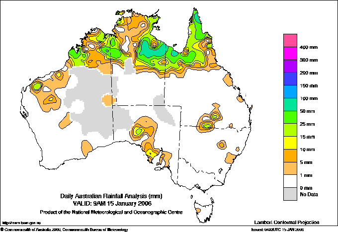
Todays highest rainfall totals for the 24 hours to 9am. It
includes the top 5 totals nationally followed by all reported falls of 50mm or more. |
Highest
and lowest recordings of hours of sunshine for the 24 hours to midnight. |
Highest wind
run totals in kilometres for the 24 hours to 9am (average speed in brackets).
All reported runs >
=25km/h are shown. |
Highest wind
gusts in km/h for the 24 hours to midnight followed by the hour in which it occurred.
All stations with gusts >
89km/h are shown. |
90.4 WOLLOGORANG N Rivers NT
84.0 MOSSMAN CENTRAL MILL N Coast--Barron QLD
81.0 MORETON TELEGRAPH STATION N Peninsula QLD
75.2 BENMARA N Rivers NT
73.6 ANTHONY LAGOON N Plateau NT
WESTERN AUSTRALIA
N Kimberley
58.4 DRYSDALE RIVER STATION
E Kimberley
62.0 HALLS CREEK AIRPORT
50.0 WARMUN
Cent Wheatbelt
68.2 YOUNDEGIN
NORTHERN TERRITORY
N Rivers
90.4 WOLLOGORANG
75.2 BENMARA
70.8 TANUMBIRINI
64.6 BRADSHAW
57.0 BRADSHAW
54.0 KILLARNEY
N Plateau
73.6 ANTHONY LAGOON
55.0 EVA DOWNS
55.0 UCHARONIDGE
SOUTH AUSTRALIA
W Agricultural
56.8 KYANCUTTA (BILLABOWIE)
QUEENSLAND
N Peninsula
81.0 MORETON TELEGRAPH STATION
62.6 BALURGA STATION
60.0 SUDLEY STATION
S Peninsula
54.0 LOCKHART RIVER AIRPORT
Gulf Country
61.4 BEAMESBROOK
60.0 BURKETOWN POST OFFICE
52.0 SWEERS ISLAND
N Coast--Barron
84.0 MOSSMAN CENTRAL MILL
64.0 LOW ISLES LIGHTHOUSE
60.0 LIZARD ISLAND RESORT
52.4 WHYANBEEL VALLEY
|
13.3 GROVE (COMPARISON) Southeast TAS
13.1 PERTH AIRPORT Lower West WA
13.1 MOUNT GAMBIER AERO Lower SE SA
13.0 MOREE AERO NW Plains E NSW
12.5 HOBART AIRPORT Southeast TAS
.....
1.5 ALBANY AIRPORT Lower West WA
1.5 WOOMERA AERODROME NW Pastoral SA
1.5 ADELAIDE (KENT TOWN) Adelaide/Lofty SA
0.6 LARRIMAH N Rivers NT
0.0 WILLIAMTOWN RAAF Hunter Valley NSW
0.0 SYDNEY AIRPORT AMO Sydney--east NSW
0.0 GOVE AIRPORT N Rivers NT
|
1034 (43.1) CAPE LEEUWIN Lower West WA
907 (37.8) MAATSUYKER ISLAND LIGHTHOUSE Southeast TAS
883 (36.8) CAPE GRIM BAPS N Coast TAS
872 (36.3) SWAN ISLAND E Coast TAS
847 (35.3) HOGAN ISLAND Islands ISL
803 (33.5) CAPE BRUNY (CAPE BRUNY) Southeast TAS
796 (33.2) CAPE WILLOUGHBY Yorke Pen/Kanga Is SA
761 (31.7) STENHOUSE BAY Yorke Pen/Kanga Is SA
753 (31.4) GREEN CAPE AWS South Coast NSW
748 (31.2) TASMAN ISLAND Southeast TAS
740 (30.8) MOUNT WELLINGTON Southeast TAS
732 (30.5) FLINDERS ISLAND AIRPORT Flinders Is/Bass St TAS
714 (29.8) WILSONS PROMONTORY LIGHTHOUSE W Gippsland VIC
711 (29.6) ALBANY AIRPORT Lower West WA
701 (29.2) LEIGH CREEK AIRPORT NE Pastoral SA
698 (29.1) CARNARVON AIRPORT W Gascoyne WA
675 (28.1) NEPTUNE ISLAND W Agricultural SA
658 (27.4) HAMILTON ISLAND AIRPORT Central Coast E QLD
654 (27.3) KILMORE GAP N Central VIC
650 (27.1) LOW HEAD N Coast TAS
636 (26.5) ESPERANCE Lower West WA
636 (26.5) HOPETOUN NORTH Lower West WA
633 (26.4) VARANUS ISLAND Islands ISL
629 (26.2) JACUP Cent Wheatbelt WA
626 (26.1) RUNDLE ISLAND Wide Bay/Burnett QLD
623 (26.0) RED ROCKS POINT Eucla WA
616 (25.7) MOUNT READ W Coast TAS
613 (25.5) WOOMERA AERODROME NW Pastoral SA
612 (25.5) THEVENARD ISLAND W Pilbara WA
611 (25.5) HARTZ MOUNTAIN (KEOGHS PIMPLE) Southeast TAS
609 (25.4) CHEADANUP Goldfields WA
604 (25.2) CAPE JAFFA (CURLEY HILLS) Lower SE SA
603 (25.1) CEDUNA AMO W Agricultural SA
|
83/12 COBAR AIRPORT AWS Upper Darling NSW
74/13 COBAR MO Upper Darling NSW
72/02 LEIGH CREEK AIRPORT NE Pastoral SA
71/19 GILES METEOROLOGICAL OFFICE Interior WA
70/18 TIBOOBURRA AIRPORT Far Northwest NSW
|
�