|
For notes on how to interpret
the data and quality control issues, see Daily Weather Summary Help.
**S** and **W** precede data flagged by the Bureau as suspicious or wrong
Data is as received at 23:41EST, 14/05/2012.
|
|
| |
Max
°
C |
+/- norm
°
C |
Min
°
C |
+/- norm
°
C |
Grass Min
°
C |
Rain to 9am mm |
Evaporation to 9am mm |
Sunshine hours |
Wind Run to 9am km (24-hour average km/h) |
Maximum Gust km/h / hour of occurrence |
| GERALDTON AIRPORT |
32.6 |
+5.5 |
16.9 |
+3.1 |
17.6 |
0.0 |
7.4 |
-- |
368 (15.3) |
63/15 |
| PERTH AIRPORT |
29.0 |
+3.2 |
17.2 |
+4.6 |
16.7 |
0.0 |
7.2 |
0.9 |
322 (13.4) |
67/18 |
| ALBANY AIRPORT |
22.8 |
+2.0 |
11.8 |
+1.0 |
10.0 |
0.0 |
6.4 |
2.4 |
241 (10.0) |
74/22 |
| BUNBURY |
25.5 |
+1.3 |
10.8 |
-1.2 |
-- |
0.0 |
-- |
-- |
219 ( 9.1) |
61/21 |
| MANDURAH |
24.6 |
-- |
18.5 |
-- |
-- |
0.0 |
-- |
-- |
262 (10.9) |
83/18 |
| DARWIN AIRPORT |
34.6 |
+1.3 |
24.5 |
-0.8 |
24.0 |
0.0 |
7.8 |
10.6 |
349 (14.5) |
41/13 |
| ALICE SPRINGS AIRPORT |
42.5 |
+8.9 |
29.1 |
+11.2 |
24.2 |
0.0 |
16.0 |
7.8 |
331 (13.8) |
43/22 |
| WHYALLA AERO |
31.0 |
+4.5 |
17.6 |
+3.7 |
-- |
0.0 |
10.6 |
-- |
424 (17.7) |
52/18 |
| ADELAIDE (KENT TOWN) |
31.7 |
+6.6 |
16.9 |
+2.9 |
-- |
0.0 |
9.0 |
13.0 |
208 ( 8.7) |
37/15 |
| MOUNT GAMBIER AERO |
26.6 |
+6.2 |
7.3 |
-1.1 |
2.9 |
0.0 |
5.4 |
13.5 |
356 (14.8) |
35/14 |
| MOUNT ISA AERO |
40.9 |
+4.5 |
21.8 |
+0.4 |
-- |
0.0 |
-- |
-- |
384 (16.0) |
37/16 |
| CAIRNS AERO |
31.9 |
+1.3 |
22.2 |
-0.1 |
20.0 |
0.8 |
9.6 |
7.3 |
379 (15.8) |
35/14 |
| TOWNSVILLE AERO |
31.0 |
+0.2 |
23.5 |
+0.6 |
21.3 |
0.0 |
11.8 |
12.5 |
461 (19.2) |
43/13 |
| MACKAY M.O |
29.6 |
+0.4 |
24.2 |
+2.5 |
-- |
0.0 |
-- |
11.6 |
350 (14.6) |
32/13 |
| ROCKHAMPTON AERO |
33.3 |
+2.1 |
18.9 |
-0.6 |
17.4 |
0.0 |
9.8 |
-- |
251 (10.5) |
35/12 |
| BUNDABERG AERO |
30.0 |
+1.7 |
17.6 |
-1.3 |
-- |
0.0 |
7.3 |
-- |
289 (12.0) |
-- |
| NAMBOUR DPI |
32.1 |
+4.1 |
16.8 |
+0.5 |
-- |
0.0 |
5.6 |
-- |
91 ( 3.8) |
30/13 |
| COOLANGATTA |
29.2 |
+3.4 |
20.1 |
+1.9 |
-- |
0.0 |
-- |
-- |
291 (12.1) |
46/15 |
| BRISBANE AERO |
30.0 |
+3.2 |
20.9 |
+2.9 |
19.2 |
0.0 |
9.0 |
10.2 |
391 (16.3) |
55/14 |
| TOOWOOMBA AIRPORT |
33.5 |
+7.8 |
17.8 |
+3.3 |
-- |
0.0 |
-- |
-- |
683 (28.5) |
54/00 |
| GUNNEDAH RESOURCE CENTRE |
36.7 |
+8.4 |
20.6 |
+5.6 |
15.8 |
2.4 |
7.8 |
-- |
158 ( 6.6) |
-- |
| COFFS HARBOUR MO |
35.9 |
+11.0 |
19.2 |
+3.1 |
17.9 |
3.2 |
4.0 |
8.2 |
294 (12.3) |
93/19 |
| PORT MACQUARIE AIRPORT AWS |
28.3 |
+3.4 |
18.9 |
+3.9 |
-- |
0.0 |
-- |
-- |
-- |
-- |
| WILLIAMTOWN RAAF |
37.5 |
+12.1 |
19.3 |
+5.0 |
17.5 |
0.4 |
3.6 |
10.5 |
337 (14.0) |
72/16 |
| GOSFORD (NARARA RESEARCH STATION) AWS |
34.7 |
+9.6 |
18.1 |
+5.0 |
15.9 |
0.0 |
-- |
-- |
90 ( 3.8) |
24/15 |
| ORANGE AGRICULTURAL INSTITUTE |
30.0 |
+8.9 |
13.7 |
+4.6 |
7.0 |
0.0 |
10.6 |
10.8 |
-- |
-- |
| DUBBO AIRPORT AWS |
37.4 |
+9.0 |
19.1 |
+5.5 |
-- |
0.0 |
-- |
-- |
-- |
-- |
| SYDNEY AIRPORT AMO |
32.7 |
+8.7 |
19.3 |
+4.0 |
17.6 |
0.0 |
3.8 |
9.9 |
-- |
48/14 |
| RICHMOND RAAF |
38.4 |
+11.8 |
16.7 |
+2.8 |
-- |
0.0 |
-- |
-- |
162 ( 6.8) |
65/14 |
| BELLAMBI AWS |
25.7 |
+3.6 |
18.3 |
+2.7 |
-- |
0.0 |
-- |
-- |
322 (13.4) |
39/22 |
| CANBERRA AIRPORT |
34.3 |
+11.6 |
15.2 |
+6.4 |
10.0 |
0.0 |
9.0 |
13.0 |
238 ( 9.9) |
54/12 |
| WAGGA WAGGA AMO |
36.6 |
+10.9 |
14.5 |
+3.8 |
13.8 |
0.0 |
11.0 |
13.4 |
237 ( 9.9) |
54/12 |
| ALBURY AIRPORT AWS |
36.3 |
+10.3 |
14.3 |
+2.7 |
-- |
0.0 |
-- |
-- |
135 ( 5.6) |
48/16 |
| MILDURA AIRPORT |
39.5 |
+12.1 |
18.1 |
+5.6 |
15.6 |
0.0 |
6.2 |
12.3 |
224 ( 9.3) |
46/16 |
| TATURA INST SUSTAINABLE AG |
-- |
-- |
10.8 |
+0.7 |
-- |
0.0 |
6.0 |
-- |
228 ( 9.5) |
-- |
| BENDIGO AIRPORT |
35.3 |
+11.1 |
13.1 |
+3.6 |
-- |
0.0 |
-- |
-- |
320 (13.3) |
�
41/17 |
| MELBOURNE REGIONAL OFFICE |
21.7 |
-0.2 |
11.7 |
+0.5 |
8.7 |
0.0 |
4.6 |
-- |
103 ( 4.3) |
21/17 |
| GEELONG AIRPORT |
18.9 |
-2.1 |
6.8 |
-2.8 |
-- |
0.0 |
-- |
-- |
237 ( 9.9) |
39/17 |
| BALLARAT AERODROME |
30.5 |
+10.9 |
8.7 |
+0.9 |
-- |
0.0 |
-- |
-- |
365 (15.2) |
48/17 |
| LAUNCESTON (TI TREE BEND) |
23.9 |
+3.5 |
7.6 |
-1.3 |
-- |
0.0 |
-- |
-- |
249 (10.4) |
43/14 |
| HOBART AIRPORT |
21.2 |
+2.2 |
6.9 |
-2.3 |
2.9 |
0.0 |
6.0 |
11.5 |
325 (13.5) |
59/23 |
| |
Max
°
C |
+/- norm
°
C |
Min
°
C |
+/- norm
°
C |
Grass Min
°
C |
Rain to 9am mm |
Evaporation to 9am mm |
Sunshine hours |
Wind Run to 9am km |
Maximum Gust km/h / hour of occurrence |
|
| Hottest |
| Highest maximum temperature> | Greatest variation above normal maximum |
Highest minimum temperature | Greatest variation above normal minimum |
46.0 BIRDSVILLE AIRPORT Channel Country QLD
45.6 BALLERA GAS FIELD Far SW QLD
45.4 MARREE NE Pastoral SA
45.1 MOOMBA AIRPORT NE Pastoral SA
45.1 MARREE AERO NE Pastoral SA
|
+16.3 : 44.1 BALLADONIA Eucla WA
+14.0 : 40.0 CAMDEN AIRPORT AWS Illawarra NSW
+13.9 : 44.0 IVANHOE POST OFFICE Southwest Plains NSW
+13.4 : 42.1 BROKEN HILL (PATTON STREET) Lower Darling NSW
+13.4 : 42.8 BALGAIR Eucla WA
+13.4 : 43.4 MENINDEE POST OFFICE Lower Darling NSW
|
32.6 THARGOMINDAH AIRPORT Far SW QLD
32.1 BALLERA GAS FIELD Far SW QLD
30.4 TIBOOBURRA POST OFFICE Far Northwest NSW
30.3 MARREE AERO NE Pastoral SA
30.0 ARKAROOLA NE Pastoral SA
|
+14.6 : 30.0 ARKAROOLA NE Pastoral SA
+12.9 : 30.4 TIBOOBURRA POST OFFICE Far Northwest NSW
+12.9 : 29.7 MARREE NE Pastoral SA
+12.5 : 29.5 ANDAMOOKA NW Pastoral SA
+12.4 : 29.0 ROXBY DOWNS (OLYMPIC DAM AERODROME) NW Pastoral SA
|
| Coldest |
| Lowest maximum temperature | Greatest variation below normal maximum |
Lowest minimum temperature | Greatest variation below normal minimum |
11.5 MAATSUYKER ISLAND LIGHTHOUSE Southeast TAS
14.7 CAPE GRIM BAPS N Coast TAS
15.1 MOUNT READ W Coast TAS
15.4 MOUNT WELLINGTON Southeast TAS
15.7 TASMAN ISLAND Southeast TAS
|
-4.3 : 26.0 DALWALLINU Central West WA
-4.1 : 31.2 GASCOYNE JUNCTION W Gascoyne WA
-4.0 : 32.5 PARDOO STATION E Pilbara WA
-3.9 : 25.5 DALWALLINU COMPARISON Central West WA
-3.9 : 27.9 MORAWA AIRPORT Central West WA
|
-0.3 LAKE ST CLAIR NATIONAL PARK Central Plateau TAS
0.5 LIAWENEE Central Plateau TAS
1.6 FLINDERS ISLAND AIRPORT Flinders Is/Bass St TAS
2.3 TARRALEAH VILLAGE Derwent Valley TAS
3.0 GROVE (RESEARCH STATION) Southeast TAS
|
-9.0 : 14.5 ELLIOTT N Plateau NT
-8.6 : 1.6 FLINDERS ISLAND AIRPORT Flinders Is/Bass St TAS
-5.9 : 4.1 KING ISLAND AIRPORT King Island TAS
-5.2 : 5.4 CERBERUS E Central VIC
-5.1 : 20.3 KUNUNURRA AERO E Kimberley WA
|
|
Sunniest &
dullest |
Windiest |
Highest gusts |
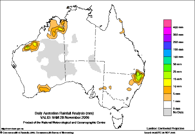
Todays highest rainfall totals for the 24 hours to 9am. It
includes the top 5 totals nationally followed by all reported falls of 50mm or more. |
Highest
and lowest recordings of hours of sunshine for the 24 hours to midnight. |
Highest wind
run totals in kilometres for the 24 hours to 9am (average speed in brackets).
All reported runs >
=25km/h are shown. |
Highest wind
gusts in km/h for the 24 hours to midnight followed by the hour in which it occurred.
All stations with gusts >
89km/h are shown. |
115.0 EBOR (WONGWIBINDA) N Tablelands E NSW
70.0 GLEN ELGIN (GLENBROOK) N Tablelands E NSW
64.6 WALLANGARRA POST OFFICE Darling Downs E QLD
60.0 JINDARE N Rivers NT
58.0 BARONGAROOK TM Darling Downs E QLD
NORTHERN TERRITORY
N Rivers
60.0 JINDARE
QUEENSLAND
Darling Downs E
64.6 WALLANGARRA POST OFFICE
58.0 BARONGAROOK TM
NEW SOUTH WALES
N Tablelands W
54.0 TENTERFIELD (SPRINGSIDE)
N Tablelands E
115.0 EBOR (WONGWIBINDA)
70.0 GLEN ELGIN (GLENBROOK)
|
13.8 ADELAIDE AIRPORT Adelaide/Lofty SA
13.6 BUNDOORA (LATROBE UNIVERSITY) E Central VIC
13.5 NURIOOTPA VITICULTURAL Adelaide/Lofty SA
13.5 MOUNT GAMBIER AERO Lower SE SA
13.4 WAGGA WAGGA AMO SW Slopes S NSW
13.4 MELBOURNE AIRPORT E Central VIC
.....
7.3 GILES METEOROLOGICAL OFFICE Interior WA
7.3 CAIRNS AERO N Coast--Barron QLD
6.0 WELLINGTON (AGROWPLOW) CW Slopes S NSW
2.4 ALBANY AIRPORT Lower West WA
0.9 PERTH AIRPORT Lower West WA
|
1182 (49.3) MAATSUYKER ISLAND LIGHTHOUSE Southeast TAS
965 (40.2) CAPE GRIM BAPS N Coast TAS
738 (30.8) HARTZ MOUNTAIN (KEOGHS PIMPLE) Southeast TAS
705 (29.4) HAMILTON ISLAND AIRPORT Central Coast E QLD
685 (28.5) WILLIS ISLAND Islands ISL
683 (28.5) TOOWOOMBA AIRPORT Darling Downs E QLD
673 (28.0) MOREE AERO NW Plains E NSW
602 (25.1) MONTAGUE ISLAND LIGHTHOUSE South Coast NSW
|
107/16 PARABURDOO AERO E Gascoyne WA
106/20 ARMIDALE AIRPORT AWS N Tablelands W NSW
102/13 NULLO MOUNTAIN AWS C Tablelands N NSW
98/15 TRANGIE RESEARCH STATION AWS CW Plains N NSW
98/21 MAATSUYKER ISLAND LIGHTHOUSE Southeast TAS
94/14 CESSNOCK AIRPORT AWS Hunter Valley NSW
93/19 COFFS HARBOUR MO MidNorth Coast N NSW
91/16 ROTTNEST ISLAND Lower West WA
|
�