|
For notes on how to interpret
the data and quality control issues, see Daily Weather Summary Help.
**S** and **W** precede data flagged by the Bureau as suspicious or wrong
Data is as received at 22:47EST, 14/05/2012.
|
|
| |
Max
°
C |
+/- norm
°
C |
Min
°
C |
+/- norm
°
C |
Grass Min
°
C |
Rain to 9am mm |
Evaporation to 9am mm |
Sunshine hours |
Wind Run to 9am km (24-hour average km/h) |
Maximum Gust km/h / hour of occurrence |
| GERALDTON AIRPORT |
24.7 |
+3.8 |
11.8 |
+0.8 |
7.6 |
0.0 |
4.2 |
-- |
374 (15.6) |
41/14 |
| PERTH AIRPORT |
19.9 |
+1.0 |
5.5 |
-3.5 |
2.8 |
0.0 |
0.4 |
9.2 |
360 (15.0) |
39/12 |
| ALBANY AIRPORT |
17.1 |
+0.5 |
5.6 |
-2.5 |
4.6 |
0.0 |
0.6 |
6.7 |
81 ( 3.4) |
18/15 |
| BUNBURY |
19.9 |
+1.5 |
2.7 |
-5.4 |
-- |
0.2 |
-- |
-- |
112 ( 4.7) |
26/11 |
| MANDURAH |
20.6 |
-- |
9.0 |
-- |
-- |
0.0 |
-- |
-- |
191 ( 8.0) |
30/14 |
| DARWIN AIRPORT |
30.0 |
-0.6 |
18.4 |
-1.5 |
17.0 |
0.0 |
5.6 |
11.3 |
339 (14.1) |
35/10 |
| ALICE SPRINGS AIRPORT |
18.0 |
-1.8 |
6.4 |
+1.3 |
2.6 |
0.0 |
18.6 |
9.0 |
220 ( 9.2) |
30/09 |
| WHYALLA AERO |
15.9 |
-1.4 |
9.0 |
+2.9 |
-- |
3.0 |
-- |
-- |
360 (15.0) |
41/15 |
| ADELAIDE (KENT TOWN) |
17.2 |
+1.1 |
5.0 |
-3.1 |
1.4 |
1.8 |
0.0 |
8.3 |
129 ( 5.4) |
34/11 |
| MOUNT GAMBIER AERO |
15.9 |
+2.1 |
2.4 |
-3.4 |
-0.4 |
0.0 |
1.4 |
7.1 |
156 ( 6.5) |
32/17 |
| MOUNT ISA AERO |
21.9 |
-3.0 |
4.6 |
-5.4 |
2.9 |
0.0 |
4.6 |
10.5 |
252 (10.5) |
41/13 |
| CAIRNS AERO |
28.1 |
+2.1 |
19.5 |
+1.7 |
16.1 |
0.0 |
3.4 |
8.9 |
133 ( 5.5) |
28/12 |
| TOWNSVILLE AERO |
26.6 |
+1.0 |
14.4 |
-0.2 |
9.8 |
0.0 |
4.4 |
9.8 |
210 ( 8.8) |
37/11 |
| MACKAY M.O |
24.8 |
+2.9 |
13.6 |
-0.4 |
-- |
0.0 |
-- |
10.7 |
273 (11.4) |
39/13 |
| ROCKHAMPTON AERO |
26.3 |
+2.8 |
8.4 |
-2.5 |
5.0 |
0.0 |
3.6 |
-- |
161 ( 6.7) |
39/15 |
| BUNDABERG AERO |
26.4 |
+3.8 |
10.8 |
-0.8 |
-- |
0.0 |
4.0 |
-- |
329 (13.7) |
-- |
| NAMBOUR DPI |
24.1 |
+2.5 |
3.7 |
-5.6 |
-- |
0.0 |
-- |
-- |
-- |
-- |
| COOLANGATTA |
21.6 |
+0.5 |
4.9 |
-6.6 |
-- |
0.0 |
-- |
-- |
176 ( 7.3) |
30/15 |
| BRISBANE AERO |
22.3 |
+1.0 |
5.8 |
-4.7 |
0.0 |
0.0 |
3.4 |
9.7 |
239 (10.0) |
30/21 |
| TOOWOOMBA AIRPORT |
18.4 |
+1.4 |
5.7 |
-1.8 |
-- |
0.0 |
-- |
-- |
306 (12.8) |
54/15 |
| GUNNEDAH (DIPNR) |
16.4 |
-0.4 |
4.2 |
-1.9 |
-1.7 |
0.0 |
3.2 |
-- |
128 ( 5.3) |
-- |
| COFFS HARBOUR MO |
20.7 |
+1.3 |
2.8 |
-6.3 |
-1.8 |
0.0 |
1.8 |
9.0 |
197 ( 8.2) |
61/16 |
| PORT MACQUARIE AIRPORT AWS |
21.2 |
+1.7 |
-1.6 |
-9.6 |
-- |
0.0 |
-- |
-- |
-- |
-- |
| WILLIAMTOWN RAAF |
19.4 |
+1.8 |
5.1 |
-2.8 |
0.2 |
0.0 |
4.6 |
9.3 |
426 (17.8) |
74/19 |
| GOSFORD (NARARA RESEARCH STATION) AWS |
19.1 |
+1.2 |
6.9 |
+0.4 |
2.3 |
0.0 |
-- |
-- |
154 ( 6.4) |
48/01 |
| ORANGE AGRICULTURAL INSTITUTE |
9.8 |
-0.7 |
3.7 |
+1.1 |
-3.3 |
0.0 |
3.0 |
2.4 |
-- |
-- |
| DUBBO AIRPORT AWS |
17.2 |
+0.8 |
-1.6 |
-6.2 |
-- |
0.0 |
-- |
-- |
-- |
-- |
| SYDNEY AIRPORT AMO |
15.5 |
-2.1 |
9.0 |
+0.5 |
4.2 |
0.0 |
2.2 |
2.2 |
404 (16.8) |
63/12 |
| RICHMOND RAAF |
17.3 |
-0.7 |
0.1 |
-4.8 |
-- |
0.2 |
-- |
-- |
127 ( 5.3) |
55/12 |
| BELLAMBI AWS |
14.3 |
-3.4 |
11.4 |
+0.4 |
-- |
0.0 |
-- |
-- |
383 (16.0) |
68/23 |
| CANBERRA AIRPORT |
9.5 |
-2.7 |
6.1 |
+5.1 |
5.8 |
24.0 |
1.2 |
0.0 |
-- |
54/21 |
| WAGGA WAGGA AMO |
13.7 |
-0.1 |
3.7 |
0.0 |
3.9 |
2.6 |
1.2 |
0.4 |
132 ( 5.5) |
30/05 |
| ALBURY AIRPORT AWS |
16.9 |
+2.7 |
4.2 |
+0.3 |
-- |
2.8 |
-- |
-- |
42 ( 1.8) |
46/01 |
| MILDURA AIRPORT |
16.7 |
+0.7 |
4.9 |
-0.3 |
3.9 |
3.0 |
1.2 |
8.0 |
-- |
35/14 |
| TATURA INST SUSTAINABLE AG |
15.9 |
+1.9 |
-- |
-- |
-- |
0.0 |
1.6 |
-- |
-- |
48/14 |
| BENDIGO AIRPORT |
15.1 |
+1.9 |
5.2 |
+1.6 |
-- |
0.0 |
-- |
-- |
-- |
�
48/11 |
| MELBOURNE REGIONAL OFFICE |
15.9 |
+1.9 |
4.9 |
-2.0 |
2.9 |
0.2 |
1.2 |
-- |
73 ( 3.0) |
24/11 |
| GEELONG AIRPORT |
15.1 |
+0.5 |
5.4 |
-0.9 |
-- |
0.6 |
-- |
-- |
112 ( 4.7) |
43/21 |
| BALLARAT AERODROME |
13.0 |
+2.2 |
1.4 |
-2.6 |
-- |
0.0 |
-- |
-- |
352 (14.7) |
48/12 |
| LAUNCESTON (TI TREE BEND) |
12.5 |
-0.6 |
4.4 |
+1.5 |
-- |
0.0 |
-- |
-- |
223 ( 9.3) |
39/10 |
| HOBART AIRPORT |
10.8 |
-2.1 |
7.4 |
+2.8 |
5.8 |
0.2 |
0.8 |
0.1 |
163 ( 6.8) |
26/22 |
| |
Max
°
C |
+/- norm
°
C |
Min
°
C |
+/- norm
°
C |
Grass Min
°
C |
Rain to 9am mm |
Evaporation to 9am mm |
Sunshine hours |
Wind Run to 9am km |
Maximum Gust km/h / hour of occurrence |
|
| Hottest |
| Highest maximum temperature> | Greatest variation above normal maximum |
Highest minimum temperature | Greatest variation above normal minimum |
32.2 COCONUT ISLAND N Peninsula QLD
32.0 BIDYADANGA W Kimberley WA
31.9 FITZROY CROSSING AERO W Kimberley WA
31.6 CURTIN AERO W Kimberley WA
31.5 DERBY AERO W Kimberley WA
31.5 WEST ROEBUCK W Kimberley WA
|
+5.3 : 28.1 KALBARRI Central West WA
+4.5 : 17.8 RUTHERGLEN RESEARCH Lower NE VIC
+4.3 : 27.5 GLADSTONE RADAR Wide Bay/Burnett QLD
+4.2 : 17.2 HUME RESERVOIR SW Slopes S NSW
+4.1 : 25.6 ATHERTON SHIRE COUNCIL N Coast--Barron QLD
|
26.0 NORTHERN ENDEAVOUR Islands ISL
26.0 COCOS ISLAND AIRPORT Islands ISL
25.9 COCONUT ISLAND N Peninsula QLD
25.9 HORN ISLAND N Peninsula QLD
24.0 WILLIS ISLAND COMPARISON Islands ISL
24.0 FLINDERS REEF Islands ISL
|
+6.7 : 19.7 LEARMONTH AIRPORT W Pilbara WA
+6.7 : 13.2 NEWMAN AERO E Gascoyne WA
+6.5 : 12.0 MERIMBULA AIRPORT AWS South Coast NSW
+6.3 : 20.4 PORT HEDLAND AIRPORT E Pilbara WA
+5.9 : 5.7 BOMBALA (THERRY STREET) Goulburn/Monaro NSW
|
| Coldest |
| Lowest maximum temperature | Greatest variation below normal maximum |
Lowest minimum temperature | Greatest variation below normal minimum |
-0.3 MT HOTHAM Upper NE VIC
-0.1 THREDBO AWS Snowy Mtns NSW
1.0 PERISHER VALLEY SKI CENTRE Snowy Mtns NSW
1.1 FALLS CREEK Upper NE VIC
1.6 MOUNT BULLER Upper NE VIC
|
-5.9 : 6.5 BOWRAL (PARRY DRIVE) Illawarra NSW
-5.8 : 8.1 COWRA RESEARCH CENTRE C Tablelands S NSW
-5.6 : 9.1 COWRA AIRPORT COMPARISON CW Slopes S NSW
-5.6 : 8.3 YOUNG AIRPORT SW Slopes N NSW
-5.4 : 9.8 QUANDIALLA POST OFFICE SW Slopes N NSW
|
-8.5 WOOLBROOK (DANGLEMAH ROAD) NW Slopes S NSW
-8.2 GLEN INNES AIRPORT AWS N Tablelands W NSW
-6.8 TENTERFIELD (FEDERATION PARK) N Tablelands W NSW
-6.0 ARMIDALE (TREE GROUP NURSERY) N Tablelands W NSW
-5.5 INVERELL (RAGLAN ST) N Tablelands W NSW
|
-9.6 : -1.6 PORT MACQUARIE AIRPORT AWS MidNorth Coast S NSW
-9.2 : -6.8 TENTERFIELD (FEDERATION PARK) N Tablelands W NSW
-8.6 : -3.8 WARWICK Darling Downs E QLD
-8.5 : -8.5 WOOLBROOK (DANGLEMAH ROAD) NW Slopes S NSW
-8.4 : -1.4 AMBERLEY AMO Brisbane/SE Coast QLD
|
|
Sunniest &
dullest |
Windiest |
Highest gusts |
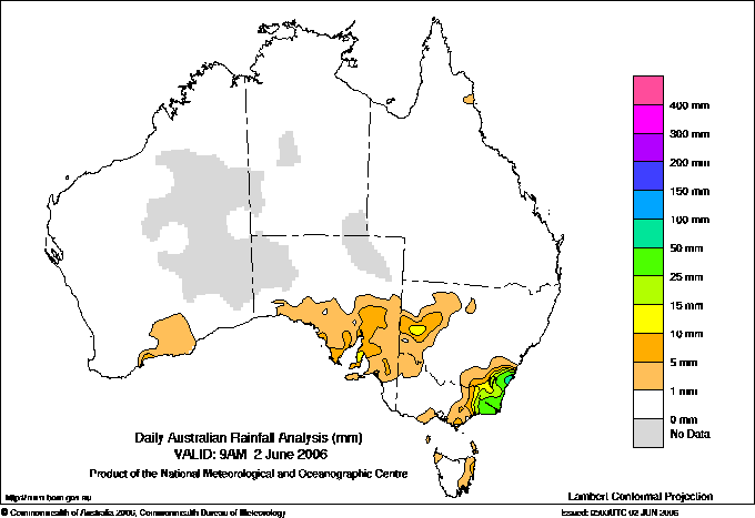
Todays highest rainfall totals for the 24 hours to 9am. It
includes the top 5 totals nationally followed by all reported falls of 50mm or more. |
Highest
and lowest recordings of hours of sunshine for the 24 hours to midnight. |
Highest wind
run totals in kilometres for the 24 hours to 9am (average speed in brackets).
All reported runs >
=25km/h are shown. |
Highest wind
gusts in km/h for the 24 hours to midnight followed by the hour in which it occurred.
All stations with gusts >
89km/h are shown. |
129.6 NORFOLK ISLAND AERO Islands ISL
107.4 JERVIS BAY (PT PERPENDICULAR AWS) Illawarra NSW
94.2 SANCTUARY POINT (SALINAS STREET) Illawarra NSW
88.0 ULLADULLA AWS South Coast NSW
87.0 SUSSEX INLET BOWLING CLUB Illawarra NSW
NEW SOUTH WALES
Illawarra
107.4 JERVIS BAY (PT PERPENDICULAR AWS)
94.2 SANCTUARY POINT (SALINAS STREET)
87.0 SUSSEX INLET BOWLING CLUB
80.4 BENDALONG (JACARANDA AV)
73.6 CALLALA BAY (DONOVAN CLOSE)
62.0 CULBURRA TREATMENT WORKS
53.6 GREENWELL POINT BOWLING CLUB
51.0 CALLALA TREATMENT PLANT
South Coast
88.0 ULLADULLA AWS
76.0 MILTON POST OFFICE
66.6 YATTEYATTAH (POINTER ROAD)
62.0 BROOMAN (CARISBROOK)
61.0 BOMBALA (MOUNTAIN TOP)
60.4 EDEN (TIMBILLICA)
60.2 BRAIDWOOD (MONGARLOWE (LEWESTON))
52.4 WAPENGO LAKE ROAD
52.2 CHARLEYONG
Goulburn/Monaro
55.2 CRAIGIE (FINCHLEY)
52.5 ROWES (LITTLE PLAINS RIVER @ WELLESLEY)
51.6 DELEGATE (WEEWALLA)
VICTORIA
E Gippsland
81.4 GENOA (FOOLS HAVEN)
68.4 WANGARABELL
59.0 GABO ISLAND LIGHTHOUSE
51.8 COMBIENBAR AWS
ISLANDS
Islands
129.6 NORFOLK ISLAND AERO
81.8 NORFOLK ISLAND (KINGSTON)
68.6 NORFOLK ISLAND (BALL BAY)
64.8 NORFOLK ISLAND (TWO CHIMNEYS RD)
|
11.3 DARWIN AIRPORT N Rivers NT
11.1 GOVE AIRPORT N Rivers NT
10.9 BROOME AIRPORT W Kimberley WA
10.7 MACKAY M.O Central Coast E QLD
10.5 MOUNT ISA AERO Gulf Country QLD
.....
0.0 WARWICK Darling Downs E QLD
0.0 CANBERRA AIRPORT Goulburn/Monaro NSW
0.0 BICHENO (COUNCIL DEPOT) E Coast TAS
0.0 LAKE LEAKE (ELIZABETH RIVER) E Coast TAS
0.0 STRATHGORDON VILLAGE W Coast TAS
0.0 COWRA RESEARCH CENTRE C Tablelands S NSW
|
948 (39.5) GREEN CAPE AWS South Coast NSW
924 (38.5) VARANUS ISLAND Islands ISL
854 (35.6) HOGAN ISLAND Islands ISL
780 (32.5) EDDYSTONE POINT E Coast TAS
776 (32.3) SWAN ISLAND E Coast TAS
720 (30.0) WILSONS PROMONTORY LIGHTHOUSE W Gippsland VIC
714 (29.8) NEPTUNE ISLAND W Agricultural SA
681 (28.4) COOBER PEDY AIRPORT NW Pastoral SA
650 (27.1) BARROW ISLAND AIRPORT W Pilbara WA
619 (25.8) MARREE AERO NE Pastoral SA
614 (25.6) WOOMERA AERODROME NW Pastoral SA
603 (25.1) COCOS ISLAND AIRPORT Islands ISL
|
94/14 MT HOTHAM Upper NE VIC
85/21 GABO ISLAND LIGHTHOUSE E Gippsland VIC
83/17 LOOKOUT HILL Western Plains VIC
78/09 MOUNT BULLER Upper NE VIC
74/19 WILLIAMTOWN RAAF Hunter Valley NSW
74/13 THREDBO AWS Snowy Mtns NSW
|
�