|
For notes on how to interpret
the data and quality control issues, see Daily Weather Summary Help.
**S** and **W** precede data flagged by the Bureau as suspicious or wrong
Data is as received at 22:13EST, 14/05/2012.
|
|
| |
Max
°
C |
+/- norm
°
C |
Min
°
C |
+/- norm
°
C |
Grass Min
°
C |
Rain to 9am mm |
Evaporation to 9am mm |
Sunshine hours |
Wind Run to 9am km (24-hour average km/h) |
Maximum Gust km/h / hour of occurrence |
| GERALDTON AIRPORT |
29.6 |
-2.9 |
23.8 |
+4.7 |
23.2 |
3.4 |
8.2 |
-- |
416 (17.3) |
54/18 |
| PERTH AIRPORT |
30.0 |
-1.8 |
22.5 |
+5.1 |
22.5 |
13.4 |
6.4 |
11.8 |
376 (15.7) |
48/16 |
| ALBANY AIRPORT |
21.8 |
-3.1 |
17.2 |
+2.8 |
16.9 |
13.2 |
8.6 |
6.3 |
601 (25.0) |
-- |
| BUNBURY |
29.1 |
-0.7 |
20.0 |
+4.4 |
-- |
0.0 |
-- |
-- |
243 (10.1) |
57/15 |
| MANDURAH |
26.6 |
-- |
22.6 |
-- |
-- |
0.0 |
-- |
-- |
292 (12.2) |
57/17 |
| DARWIN AIRPORT |
32.3 |
+0.9 |
24.9 |
+0.2 |
24.5 |
0.0 |
6.4 |
6.0 |
302 (12.6) |
35/15 |
| ALICE SPRINGS AIRPORT |
39.2 |
+4.1 |
24.9 |
+4.1 |
22.9 |
1.2 |
11.4 |
11.9 |
427 (17.8) |
41/11 |
| WHYALLA AERO |
26.8 |
-2.8 |
14.0 |
-3.7 |
-- |
0.0 |
7.4 |
-- |
745 (31.0) |
50/03 |
| ADELAIDE (KENT TOWN) |
26.9 |
-2.4 |
13.0 |
-4.1 |
9.8 |
0.0 |
9.8 |
13.0 |
349 (14.5) |
35/03 |
| MOUNT GAMBIER AERO |
22.5 |
-2.6 |
7.9 |
-3.7 |
5.7 |
0.6 |
5.0 |
11.6 |
512 (21.3) |
45/15 |
| MOUNT ISA AERO |
38.7 |
+3.4 |
22.0 |
-1.4 |
23.0 |
6.0 |
6.2 |
11.5 |
265 (11.0) |
41/02 |
| CAIRNS AERO |
33.0 |
+1.8 |
25.0 |
+1.3 |
23.5 |
0.0 |
7.2 |
10.2 |
290 (12.1) |
28/15 |
| TOWNSVILLE AERO |
34.1 |
+3.0 |
26.0 |
+1.9 |
24.8 |
1.4 |
6.4 |
10.4 |
384 (16.0) |
35/11 |
| MACKAY M.O |
31.5 |
+1.9 |
23.8 |
+0.4 |
-- |
0.0 |
-- |
10.4 |
319 (13.3) |
34/14 |
| ROCKHAMPTON AERO |
37.1 |
+5.8 |
24.1 |
+2.0 |
23.1 |
0.0 |
8.6 |
-- |
259 (10.8) |
35/16 |
| BUNDABERG AERO |
33.0 |
+3.1 |
20.9 |
-0.5 |
-- |
0.0 |
7.8 |
-- |
184 ( 7.7) |
-- |
| NAMBOUR DPI |
31.4 |
+2.6 |
18.6 |
-1.1 |
-- |
0.0 |
5.4 |
-- |
-- |
-- |
| COOLANGATTA |
27.0 |
-1.2 |
23.6 |
+2.8 |
-- |
1.0 |
-- |
-- |
366 (15.3) |
57/17 |
| BRISBANE AERO |
31.3 |
+2.2 |
21.3 |
+0.2 |
18.5 |
0.0 |
8.0 |
6.5 |
389 (16.2) |
55/19 |
| TOOWOOMBA AIRPORT |
30.0 |
+2.6 |
18.5 |
+0.9 |
-- |
0.0 |
-- |
-- |
449 (18.7) |
65/22 |
| GUNNEDAH (DIPNR) |
31.4 |
+0.3 |
23.0 |
+4.4 |
14.0 |
0.0 |
9.8 |
-- |
232 ( 9.7) |
-- |
| COFFS HARBOUR MO |
26.0 |
-0.8 |
22.5 |
+3.0 |
21.3 |
4.0 |
8.0 |
3.5 |
633 (26.4) |
72/10 |
| PORT MACQUARIE AIRPORT AWS |
25.0 |
-2.5 |
20.2 |
+1.9 |
-- |
0.2 |
-- |
-- |
-- |
-- |
| WILLIAMTOWN RAAF |
26.0 |
-1.5 |
20.7 |
+2.6 |
19.0 |
0.0 |
12.0 |
6.5 |
592 (24.7) |
76/02 |
| GOSFORD (NARARA RESEARCH STATION) AWS |
22.0 |
-5.1 |
18.6 |
+1.5 |
18.4 |
0.0 |
-- |
-- |
274 (11.4) |
44/00 |
| ORANGE AGRICULTURAL INSTITUTE |
23.0 |
-2.8 |
10.0 |
-3.1 |
2.0 |
0.0 |
8.2 |
12.5 |
-- |
-- |
| DUBBO AIRPORT AWS |
32.2 |
+0.2 |
18.2 |
+0.5 |
-- |
0.0 |
-- |
-- |
-- |
-- |
| SYDNEY AIRPORT AMO |
22.7 |
-3.6 |
19.8 |
+0.8 |
15.9 |
0.0 |
11.4 |
2.1 |
922 (38.4) |
81/00 |
| RICHMOND RAAF |
22.8 |
-6.2 |
19.2 |
+1.6 |
-- |
0.0 |
-- |
-- |
388 (16.2) |
54/23 |
| BELLAMBI AWS |
22.0 |
-2.8 |
18.6 |
-0.5 |
-- |
0.0 |
-- |
-- |
867 (36.1) |
72/00 |
| CANBERRA AIRPORT |
23.5 |
-3.6 |
11.4 |
-1.7 |
10.1 |
0.0 |
13.2 |
11.5 |
485 (20.2) |
45/18 |
| WAGGA WAGGA AMO |
28.8 |
-2.1 |
8.9 |
-7.4 |
7.5 |
0.0 |
14.4 |
12.9 |
505 (21.0) |
55/22 |
| ALBURY AIRPORT AWS |
28.4 |
-2.9 |
11.3 |
-4.8 |
-- |
0.0 |
-- |
-- |
-- |
-- |
| MILDURA AIRPORT |
27.2 |
-4.4 |
10.9 |
-5.5 |
9.5 |
0.0 |
13.0 |
12.9 |
495 (20.6) |
45/00 |
| TATURA INST SUSTAINABLE AG |
24.0 |
-5.5 |
7.7 |
-6.6 |
6.9 |
0.0 |
10.2 |
-- |
509 (21.2) |
46/10 |
| BENDIGO AIRPORT |
23.6 |
-5.8 |
8.2 |
-5.9 |
-- |
0.0 |
-- |
-- |
491 (20.5) |
�
46/11 |
| MELBOURNE REGIONAL OFFICE |
21.0 |
-4.8 |
13.8 |
-0.8 |
12.3 |
0.0 |
4.8 |
-- |
154 ( 6.4) |
22/00 |
| GEELONG AIRPORT |
19.6 |
-5.4 |
10.5 |
-2.9 |
-- |
0.0 |
-- |
-- |
520 (21.7) |
43/14 |
| BALLARAT AERODROME |
21.0 |
-4.0 |
5.8 |
-5.6 |
-- |
0.0 |
-- |
-- |
527 (22.0) |
46/08 |
| LAUNCESTON (TI TREE BEND) |
22.2 |
-2.2 |
6.6 |
-5.4 |
-- |
0.0 |
-- |
-- |
351 (14.6) |
31/10 |
| HOBART AIRPORT |
18.2 |
-4.1 |
7.9 |
-4.1 |
2.6 |
0.6 |
7.4 |
4.1 |
621 (25.9) |
43/02 |
| |
Max
°
C |
+/- norm
°
C |
Min
°
C |
+/- norm
°
C |
Grass Min
°
C |
Rain to 9am mm |
Evaporation to 9am mm |
Sunshine hours |
Wind Run to 9am km |
Maximum Gust km/h / hour of occurrence |
|
| Hottest |
| Highest maximum temperature> | Greatest variation above normal maximum |
Highest minimum temperature | Greatest variation above normal minimum |
43.9 BOULIA AIRPORT Channel Country QLD
43.3 BEDOURIE POLICE STATION Channel Country QLD
43.0 JERVOIS N Plateau NT
42.2 ISISFORD POST OFFICE Central West QLD
42.0 LONGREACH AERO Central West QLD
42.0 URANDANGI Northwest QLD
|
+6.6 : 39.5 MITCHELL POST OFFICE Maranoa QLD
+6.5 : 43.9 BOULIA AIRPORT Channel Country QLD
+6.4 : 42.2 ISISFORD POST OFFICE Central West QLD
+6.3 : 40.1 TAMBO POST OFFICE Central Highlands QLD
+6.2 : 39.8 LAVERTON AERO Goldfields WA
+6.2 : 43.0 JERVOIS N Plateau NT
+6.2 : 42.0 LONGREACH AERO Central West QLD
|
30.4 QUILPIE AIRPORT Far SW QLD
30.2 BEDOURIE POLICE STATION Channel Country QLD
29.1 BOULIA AIRPORT Channel Country QLD
28.1 THARGOMINDAH AIRPORT Far SW QLD
28.0 CENTRE ISLAND N Rivers NT
28.0 BALLERA GAS FIELD Far SW QLD
28.0 NORTHERN ENDEAVOUR Islands ISL
|
+7.5 : 19.7 BRIDGETOWN COMPARISON Lower West WA
+7.2 : 21.5 WANDERING Cent Wheatbelt WA
+7.1 : 30.4 QUILPIE AIRPORT Far SW QLD
+6.9 : 24.1 SOUTHERN CROSS Goldfields WA
+6.4 : 23.7 SOUTHERN CROSS AIRFIELD Goldfields WA
|
| Coldest |
| Lowest maximum temperature | Greatest variation below normal maximum |
Lowest minimum temperature | Greatest variation below normal minimum |
8.0 MOUNT READ W Coast TAS
10.0 MOUNT WELLINGTON Southeast TAS
10.0 WARRA W Coast TAS
10.3 HARTZ MOUNTAIN (KEOGHS PIMPLE) Southeast TAS
11.2 MT BAW BAW W Gippsland VIC
|
-9.4 : 11.4 SCOTTS PEAK DAM W Coast TAS
-8.3 : 14.0 MAYDENA POST OFFICE Derwent Valley TAS
-7.9 : 21.7 SALMON GUMS RES.STN. Goldfields WA
-7.8 : 14.2 GEEVESTON (CEMETERY ROAD) Southeast TAS
-7.7 : 17.0 LITHGOW (BIRDWOOD ST) C Tablelands S NSW
|
-3.4 CHARLOTTE PASS (KOSCIUSKO CHALET) Snowy Mtns NSW
-2.7 MT HOTHAM Upper NE VIC
-2.0 PERISHER VALLEY SKI CENTRE Snowy Mtns NSW
-2.0 MOUNT WELLINGTON Southeast TAS
-1.7 FALLS CREEK Upper NE VIC
|
-10.7 : -2.7 MT HOTHAM Upper NE VIC
-10.3 : -1.7 FALLS CREEK Upper NE VIC
-9.7 : 1.4 SCOTTSDALE (WEST MINSTONE ROAD) N Coast TAS
-9.6 : -1.0 MOUNT BULLER Upper NE VIC
-9.2 : 4.1 CASTLEMAINE PRISON N Central VIC
|
|
Sunniest &
dullest |
Windiest |
Highest gusts |
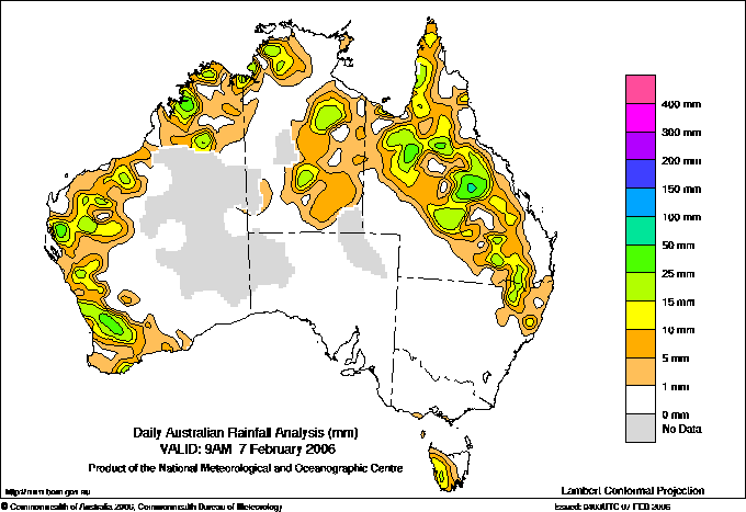
Todays highest rainfall totals for the 24 hours to 9am. It
includes the top 5 totals nationally followed by all reported falls of 50mm or more. |
Highest
and lowest recordings of hours of sunshine for the 24 hours to midnight. |
Highest wind
run totals in kilometres for the 24 hours to 9am (average speed in brackets).
All reported runs >
=25km/h are shown. |
Highest wind
gusts in km/h for the 24 hours to midnight followed by the hour in which it occurred.
All stations with gusts >
89km/h are shown. |
64.0 HAPPY VALLEY Cent Wheatbelt WA
56.2 DOWERIN Cent Wheatbelt WA
54.0 REDWING Cent Wheatbelt WA
52.4 MOUNT COTTON WEST Brisbane/SE Coast QLD
52.0 WYALKATCHEM Cent Wheatbelt WA
WESTERN AUSTRALIA
Cent Wheatbelt
64.0 HAPPY VALLEY
56.2 DOWERIN
54.0 REDWING
52.0 WYALKATCHEM
QUEENSLAND
Brisbane/SE Coast
52.4 MOUNT COTTON WEST
|
13.1 WOOMERA AERODROME NW Pastoral SA
13.1 ADELAIDE AIRPORT Adelaide/Lofty SA
13.0 ADELAIDE (KENT TOWN) Adelaide/Lofty SA
13.0 NURIOOTPA VITICULTURAL Adelaide/Lofty SA
12.9 COBAR MO Upper Darling NSW
12.9 WAGGA WAGGA AMO SW Slopes S NSW
12.9 MILDURA AIRPORT Mallee N VIC
.....
2.7 STRATHGORDON VILLAGE W Coast TAS
2.6 ALSTONVILLE TROPICAL FRUIT RESEARCH STAT North Coast NSW
2.3 NORFOLK ISLAND AERO Islands ISL
2.1 SYDNEY AIRPORT AMO Sydney--east NSW
0.0 WARWICK Darling Downs E QLD
|
1543 (64.3) MAATSUYKER ISLAND LIGHTHOUSE Southeast TAS
1499 (62.5) WILSONS PROMONTORY LIGHTHOUSE W Gippsland VIC
1498 (62.4) HOGAN ISLAND Islands ISL
1475 (61.5) CAPE GRIM BAPS N Coast TAS
1358 (56.6) MOUNT WELLINGTON Southeast TAS
1175 (49.0) CAPE BRUNY (CAPE BRUNY) Southeast TAS
1152 (48.0) FLINDERS ISLAND AIRPORT Flinders Is/Bass St TAS
1095 (45.6) MOUNT READ W Coast TAS
981 (40.9) LOW HEAD N Coast TAS
935 (39.0) SCOTTS PEAK DAM W Coast TAS
922 (38.4) SYDNEY AIRPORT AMO Sydney--east NSW
899 (37.5) CAPE OTWAY LIGHTHOUSE W Coast VIC
884 (36.8) LIAWENEE Central Plateau TAS
867 (36.1) BELLAMBI AWS Illawarra NSW
861 (35.9) HARTZ MOUNTAIN (KEOGHS PIMPLE) Southeast TAS
859 (35.8) NORAH HEAD AWS Hunter Valley NSW
832 (34.7) CAPE WILLOUGHBY Yorke Pen/Kanga Is SA
828 (34.5) KING ISLAND AIRPORT King Island TAS
824 (34.3) NEPTUNE ISLAND W Agricultural SA
811 (33.8) NEWCASTLE NOBBYS SIGNAL STATION AWS Hunter Valley NSW
807 (33.6) SWAN ISLAND E Coast TAS
795 (33.1) MARREE AERO NE Pastoral SA
780 (32.5) ULLADULLA AWS South Coast NSW
754 (31.4) COLAC (MT GELLIBRAND) W Coast VIC
753 (31.4) MT HOTHAM Upper NE VIC
745 (31.0) COOBER PEDY AIRPORT NW Pastoral SA
745 (31.0) WHYALLA AERO W Agricultural SA
729 (30.4) CEDUNA AMO W Agricultural SA
728 (30.3) WOOMERA AERODROME NW Pastoral SA
720 (30.0) DEVONPORT AIRPORT N Coast TAS
715 (29.8) STRAHAN AERODROME W Coast TAS
708 (29.5) PORT FAIRY AWS W Coast VIC
702 (29.3) STENHOUSE BAY Yorke Pen/Kanga Is SA
688 (28.7) SMITHTON AERODROME N Coast TAS
684 (28.5) PARAWA (SECOND VALLEY FOREST AWS) Adelaide/Lofty SA
680 (28.3) NORTH SHIELDS (PORT LINCOLN AWS) W Agricultural SA
679 (28.3) THREDBO AWS Snowy Mtns NSW
674 (28.1) AIREYS INLET W Coast VIC
674 (28.1) MOOMBA AIRPORT NE Pastoral SA
670 (27.9) YUNTA AIRSTRIP Northeast SA
667 (27.8) EDDYSTONE POINT E Coast TAS
666 (27.8) TIBOOBURRA AIRPORT Far Northwest NSW
663 (27.6) CLEVE AERODROME W Agricultural SA
656 (27.3) EDITHBURGH Yorke Pen/Kanga Is SA
656 (27.3) WARRNAMBOOL AIRPORT NDB W Coast VIC
651 (27.1) EAST SALE AIRPORT W Gippsland VIC
648 (27.0) ESPERANCE Lower West WA
648 (27.0) LAVERTON AERO Goldfields WA
647 (27.0) BAIRNSDALE AIRPORT W Gippsland VIC
639 (26.6) MELBOURNE AIRPORT E Central VIC
633 (26.4) MOUNT CRAWFORD FIRE TOWER Adelaide/Lofty SA
633 (26.4) COFFS HARBOUR MO MidNorth Coast N NSW
630 (26.3) LOOKOUT HILL Western Plains VIC
629 (26.2) KILMORE GAP N Central VIC
628 (26.2) LEIGH CREEK AIRPORT NE Pastoral SA
627 (26.1) MT BAW BAW W Gippsland VIC
627 (26.1) TASMAN ISLAND Southeast TAS
626 (26.1) MORWELL (LATROBE VALLEY AIRPORT) W Gippsland VIC
623 (26.0) YARRAWONGA Upper North VIC
621 (25.9) THARGOMINDAH AIRPORT Far SW QLD
621 (25.9) HOBART AIRPORT Southeast TAS
618 (25.8) CAMPANIA (KINCORA) Southeast TAS
617 (25.7) WYNYARD AIRPORT N Coast TAS
616 (25.7) WALPEUP RESEARCH Mallee N VIC
613 (25.5) SWAN HILL AERODROME Mallee S VIC
607 (25.3) TARCOOLA AERO NW Pastoral SA
604 (25.2) SHEFFIELD SCHOOL FARM N Coast TAS
604 (25.2) FORREST Eucla WA
601 (25.0) ALBANY AIRPORT Lower West WA
|
106/20 CAPE MORETON LIGHTHOUSE Brisbane/SE Coast QLD
98/01 CAPE BRUNY (CAPE BRUNY) Southeast TAS
96/21 DOUBLE ISLAND POINT LIGHTHOUSE Brisbane/SE Coast QLD
89/23 WILSONS PROMONTORY LIGHTHOUSE W Gippsland VIC
89/13 MEEKATHARRA AIRPORT E Gascoyne WA
|
�