|
For notes on how to interpret
the data and quality control issues, see Daily Weather Summary Help.
**S** and **W** precede data flagged by the Bureau as suspicious or wrong
Data is as received at 23:32EST, 14/05/2012.
|
|
| |
Max
°
C |
+/- norm
°
C |
Min
°
C |
+/- norm
°
C |
Grass Min
°
C |
Rain to 9am mm |
Evaporation to 9am mm |
Sunshine hours |
Wind Run to 9am km (24-hour average km/h) |
Maximum Gust km/h / hour of occurrence |
| GERALDTON AIRPORT |
23.6 |
-0.8 |
18.0 |
+7.1 |
16.9 |
0.0 |
6.2 |
-- |
483 (20.1) |
41/16 |
| PERTH AIRPORT |
22.0 |
-0.5 |
14.9 |
+4.7 |
13.9 |
2.0 |
6.0 |
4.6 |
341 (14.2) |
41/14 |
| ALBANY AIRPORT |
18.3 |
-0.4 |
11.6 |
+2.5 |
8.9 |
0.0 |
6.2 |
2.4 |
416 (17.3) |
39/13 |
| BUNBURY |
23.1 |
+2.4 |
14.6 |
+5.4 |
-- |
0.0 |
-- |
-- |
326 (13.6) |
44/14 |
| MANDURAH |
21.9 |
-- |
17.2 |
-- |
-- |
0.0 |
-- |
-- |
403 (16.8) |
44/15 |
| DARWIN AIRPORT |
33.2 |
0.0 |
23.2 |
-1.8 |
22.7 |
0.0 |
8.1 |
10.7 |
345 (14.4) |
35/14 |
| ALICE SPRINGS AIRPORT |
33.3 |
+2.3 |
18.0 |
+3.2 |
14.0 |
0.0 |
13.8 |
9.5 |
457 (19.0) |
41/00 |
| WHYALLA AERO |
19.2 |
-4.7 |
11.2 |
+0.7 |
-- |
0.0 |
9.2 |
-- |
430 (17.9) |
39/10 |
| ADELAIDE (KENT TOWN) |
19.3 |
-2.5 |
8.2 |
-3.2 |
3.1 |
0.0 |
2.8 |
11.9 |
178 ( 7.4) |
-- |
| MOUNT GAMBIER AERO |
13.4 |
-4.5 |
2.7 |
-4.4 |
0.6 |
0.2 |
2.6 |
0.9 |
259 (10.8) |
26/14 |
| MOUNT ISA AERO |
36.7 |
+2.1 |
22.9 |
+4.3 |
17.3 |
0.0 |
8.2 |
11.9 |
368 (15.3) |
37/15 |
| CAIRNS AERO |
28.5 |
-1.0 |
19.4 |
-1.2 |
16.0 |
0.0 |
6.6 |
11.8 |
193 ( 8.0) |
32/11 |
| TOWNSVILLE AERO |
31.0 |
+1.6 |
20.3 |
-0.4 |
18.1 |
0.0 |
6.4 |
11.0 |
233 ( 9.7) |
30/16 |
| MACKAY M.O |
30.1 |
+2.5 |
21.3 |
+1.6 |
-- |
0.0 |
-- |
10.1 |
369 (15.4) |
30/01 |
| ROCKHAMPTON AERO |
30.0 |
+0.3 |
18.7 |
+1.7 |
16.6 |
0.0 |
7.8 |
-- |
282 (11.8) |
48/11 |
| BUNDABERG AERO |
27.4 |
+0.5 |
16.6 |
0.0 |
-- |
0.0 |
4.4 |
-- |
484 (20.2) |
48/08 |
| NAMBOUR DPI |
24.0 |
-2.7 |
16.6 |
+2.8 |
-- |
0.0 |
-- |
-- |
126 ( 5.3) |
30/09 |
| COOLANGATTA |
23.9 |
-0.5 |
16.6 |
+0.4 |
-- |
0.0 |
-- |
-- |
495 (20.6) |
44/01 |
| BRISBANE AERO |
24.4 |
-1.1 |
17.1 |
+1.4 |
15.5 |
0.0 |
10.2 |
11.8 |
525 (21.9) |
43/00 |
| TOOWOOMBA AIRPORT |
24.4 |
-0.3 |
11.5 |
-1.3 |
-- |
0.0 |
-- |
-- |
666 (27.8) |
59/18 |
| GUNNEDAH RESOURCE CENTRE |
25.9 |
+0.8 |
9.4 |
-2.7 |
5.6 |
0.0 |
8.4 |
-- |
208 ( 8.7) |
-- |
| COFFS HARBOUR MO |
20.6 |
-3.0 |
14.3 |
+0.5 |
13.2 |
0.0 |
8.0 |
9.4 |
475 (19.8) |
32/08 |
| PORT MACQUARIE AIRPORT AWS |
20.8 |
-3.2 |
9.5 |
-2.4 |
-- |
0.0 |
-- |
-- |
-- |
-- |
| WILLIAMTOWN RAAF |
19.4 |
-4.2 |
9.8 |
-2.2 |
8.5 |
0.2 |
9.8 |
8.3 |
509 (21.2) |
-- |
| GOSFORD (NARARA RESEARCH STATION) AWS |
18.5 |
-5.2 |
4.9 |
-5.8 |
2.3 |
0.0 |
-- |
-- |
180 ( 7.5) |
-- |
| ORANGE AGRICULTURAL INSTITUTE |
18.6 |
+1.1 |
0.3 |
-6.3 |
-5.2 |
0.0 |
5.8 |
12.0 |
-- |
-- |
| DUBBO AIRPORT AWS |
24.0 |
-0.8 |
2.8 |
-6.6 |
-- |
0.0 |
-- |
-- |
-- |
-- |
| SYDNEY AIRPORT AMO |
18.7 |
-3.8 |
9.8 |
-3.3 |
5.0 |
0.0 |
9.4 |
12.3 |
732 (30.5) |
43/04 |
| RICHMOND RAAF |
20.6 |
-4.4 |
4.6 |
-6.4 |
-- |
0.0 |
-- |
-- |
223 ( 9.3) |
34/15 |
| BELLAMBI AWS |
17.9 |
-3.7 |
10.4 |
-3.5 |
-- |
0.0 |
-- |
-- |
545 (22.7) |
34/07 |
| CANBERRA AIRPORT |
19.1 |
-0.3 |
-0.8 |
-6.9 |
-4.6 |
0.0 |
6.2 |
12.8 |
304 (12.7) |
45/19 |
| WAGGA WAGGA AMO |
22.2 |
+0.8 |
3.7 |
-4.0 |
-5.5 |
0.0 |
7.4 |
13.0 |
396 (16.5) |
32/10 |
| ALBURY AIRPORT AWS |
21.3 |
-0.3 |
5.7 |
-2.3 |
-- |
0.0 |
-- |
-- |
317 (13.2) |
30/14 |
| MILDURA AIRPORT |
21.4 |
-2.4 |
3.9 |
-5.9 |
-- |
0.0 |
6.4 |
12.6 |
305 (12.7) |
28/18 |
| TATURA INST SUSTAINABLE AG |
19.0 |
-1.9 |
3.0 |
-4.5 |
-- |
0.0 |
-- |
-- |
-- |
-- |
| BENDIGO AIRPORT |
19.0 |
-1.3 |
3.0 |
-3.3 |
-- |
0.0 |
-- |
-- |
-- |
�
-- |
| MELBOURNE REGIONAL OFFICE |
16.6 |
-3.0 |
8.4 |
-1.1 |
7.3 |
0.2 |
4.2 |
-- |
-- |
18/11 |
| GEELONG AIRPORT |
13.3 |
-5.5 |
5.0 |
-2.6 |
-- |
1.2 |
-- |
-- |
357 (14.9) |
31/13 |
| BALLARAT AERODROME |
15.0 |
-1.6 |
-3.0 |
-9.2 |
-- |
0.0 |
-- |
-- |
-- |
-- |
| LAUNCESTON (TI TREE BEND) |
17.5 |
-0.5 |
-0.3 |
-7.2 |
-- |
0.0 |
-- |
-- |
304 (12.7) |
35/15 |
| HOBART AIRPORT |
15.4 |
-1.9 |
4.4 |
-3.1 |
2.9 |
0.0 |
4.0 |
12.1 |
552 (23.0) |
37/16 |
| |
Max
°
C |
+/- norm
°
C |
Min
°
C |
+/- norm
°
C |
Grass Min
°
C |
Rain to 9am mm |
Evaporation to 9am mm |
Sunshine hours |
Wind Run to 9am km |
Maximum Gust km/h / hour of occurrence |
|
| Hottest |
| Highest maximum temperature> | Greatest variation above normal maximum |
Highest minimum temperature | Greatest variation above normal minimum |
41.8 NORMANTON AIRPORT Gulf Country QLD
41.0 LAJAMANU N Rivers NT
40.6 BURKETOWN AIRPORT Gulf Country QLD
40.6 PORT HEDLAND AIRPORT E Pilbara WA
40.3 MARBLE BAR E Pilbara WA
|
+8.8 : 27.5 PEMBERTON Lower West WA
+8.5 : 29.7 ESPERANCE AERO Lower West WA
+8.4 : 31.7 SALMON GUMS RES.STN. Goldfields WA
+8.4 : 29.8 JACUP Cent Wheatbelt WA
|
28.8 WYNDHAM AERO N Kimberley WA
28.3 KIDMAN SPRINGS N Rivers NT
28.0 TROUGHTON ISLAND N Kimberley WA
27.9 BIDYADANGA W Kimberley WA
27.1 BRUNETTE DOWNS N Plateau NT
|
+8.4 : 15.2 BRIDGETOWN COMPARISON Lower West WA
+8.0 : 17.1 NORSEMAN AERO Goldfields WA
+7.9 : 14.8 NEWDEGATE RES.STATION Cent Wheatbelt WA
+7.7 : 24.3 ONSLOW W Pilbara WA
+7.7 : 15.0 JARRAHWOOD Lower West WA
|
| Coldest |
| Lowest maximum temperature | Greatest variation below normal maximum |
Lowest minimum temperature | Greatest variation below normal minimum |
4.8 MOUNT WELLINGTON Southeast TAS
5.1 MOUNT READ W Coast TAS
5.5 MT BAW BAW W Gippsland VIC
8.0 GRAMPIANS (MOUNT WILLIAM) Wimmera S VIC
8.0 WEEAPROINAH W Coast VIC
|
-6.3 : 16.7 PEATS RIDGE (WARATAH ROAD) Hunter Valley NSW
-5.6 : 8.0 WEEAPROINAH W Coast VIC
-5.5 : 19.6 CESSNOCK AIRPORT AWS Hunter Valley NSW
-5.5 : 13.3 GEELONG AIRPORT W Central VIC
-5.4 : 12.0 POINT WILSON W Central VIC
-5.4 : 19.2 NEWCASTLE UNIVERSITY Hunter Valley NSW
|
-9.1 THREDBO AWS Snowy Mtns NSW
-7.6 COOMA AIRPORT AWS Goulburn/Monaro NSW
-7.2 MT HOTHAM Upper NE VIC
-7.0 MT HOTHAM AIRPORT Upper NE VIC
-6.7 FALLS CREEK Upper NE VIC
|
-11.5 : -6.0 BRAIDWOOD RACECOURSE AWS South Coast NSW
-11.4 : -5.2 NERRIGA COMPOSITE South Coast NSW
-10.9 : -7.6 COOMA AIRPORT AWS Goulburn/Monaro NSW
-10.9 : -5.6 GOULBURN AIRPORT AWS Goulburn/Monaro NSW
-10.1 : -1.0 MORUYA AIRPORT AWS South Coast NSW
|
|
Sunniest &
dullest |
Windiest |
Highest gusts |
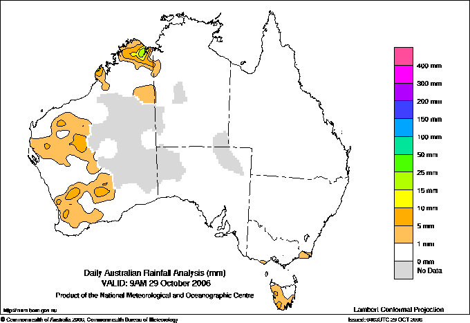
Todays highest rainfall totals for the 24 hours to 9am. It
includes the top 5 totals nationally followed by all reported falls of 50mm or more. |
Highest
and lowest recordings of hours of sunshine for the 24 hours to midnight. |
Highest wind
run totals in kilometres for the 24 hours to 9am (average speed in brackets).
All reported runs >
=25km/h are shown. |
Highest wind
gusts in km/h for the 24 hours to midnight followed by the hour in which it occurred.
All stations with gusts >
89km/h are shown. |
57.0 THEDA N Kimberley WA
46.0 ROEBUCK PLAINS W Kimberley WA
27.0 WINDARLING Goldfields WA
19.2 CHITTERING HEIGHTS Lower West WA
18.6 MAYSBORO Central West WA
WESTERN AUSTRALIA
N Kimberley
57.0 THEDA
W Kimberley
46.0 ROEBUCK PLAINS
Central West
18.6 MAYSBORO
Lower West
19.2 CHITTERING HEIGHTS
Goldfields
27.0 WINDARLING
|
13.0 COBAR MO Upper Darling NSW
13.0 WAGGA WAGGA AMO SW Slopes S NSW
12.8 MOREE AERO NW Plains E NSW
12.8 CANBERRA AIRPORT Goulburn/Monaro NSW
12.7 NURIOOTPA VITICULTURAL Adelaide/Lofty SA
.....
3.5 NORFOLK ISLAND AERO Islands ISL
2.4 ALBANY AIRPORT Lower West WA
1.5 STRATHGORDON VILLAGE W Coast TAS
0.9 MOUNT GAMBIER AERO Lower SE SA
0.0 WARWICK Darling Downs E QLD
|
952 (39.7) CAPE MORETON LIGHTHOUSE Brisbane/SE Coast QLD
951 (39.6) GREEN CAPE AWS South Coast NSW
918 (38.3) EDDYSTONE POINT E Coast TAS
906 (37.8) DOUBLE ISLAND POINT LIGHTHOUSE Brisbane/SE Coast QLD
891 (37.1) MONTAGUE ISLAND LIGHTHOUSE South Coast NSW
838 (34.9) MAATSUYKER ISLAND LIGHTHOUSE Southeast TAS
831 (34.6) HARTZ MOUNTAIN (KEOGHS PIMPLE) Southeast TAS
822 (34.3) CAPE GRIM BAPS N Coast TAS
803 (33.5) WILSONS PROMONTORY LIGHTHOUSE W Gippsland VIC
732 (30.5) SYDNEY AIRPORT AMO Sydney--east NSW
731 (30.5) ROTTNEST ISLAND Lower West WA
730 (30.4) HAMILTON ISLAND AIRPORT Central Coast E QLD
716 (29.8) HOGAN ISLAND Islands ISL
708 (29.5) NEWCASTLE NOBBYS SIGNAL STATION AWS Hunter Valley NSW
705 (29.4) TASMAN ISLAND Southeast TAS
697 (29.0) CAPE BRUNY (CAPE BRUNY) Southeast TAS
690 (28.8) GOLD COAST SEAWAY Brisbane/SE Coast QLD
681 (28.4) BYRON BAY (CAPE BYRON AWS) North Coast NSW
666 (27.8) TOOWOOMBA AIRPORT Darling Downs E QLD
656 (27.3) RUNDLE ISLAND Wide Bay/Burnett QLD
635 (26.5) ULLADULLA AWS South Coast NSW
616 (25.7) CAPE NATURALISTE Lower West WA
613 (25.5) MT HOTHAM Upper NE VIC
606 (25.3) HERON ISLAND RES STN Wide Bay/Burnett QLD
606 (25.3) OAKEY AERO Darling Downs E QLD
601 (25.0) LIAWENEE Central Plateau TAS
|
85/00 CAPE MORETON LIGHTHOUSE Brisbane/SE Coast QLD
80/02 DOUBLE ISLAND POINT LIGHTHOUSE Brisbane/SE Coast QLD
72/15 KUNUNURRA AERO E Kimberley WA
65/10 ROEBOURNE AERO E Pilbara WA
65/08 RUNDLE ISLAND Wide Bay/Burnett QLD
65/06 HARTZ MOUNTAIN (KEOGHS PIMPLE) Southeast TAS
|
�