|
For notes on how to interpret
the data and quality control issues, see Daily Weather Summary Help.
**S** and **W** precede data flagged by the Bureau as suspicious or wrong
Data is as received at 22:33EST, 14/05/2012.
|
|
| |
Max
°
C |
+/- norm
°
C |
Min
°
C |
+/- norm
°
C |
Grass Min
°
C |
Rain to 9am mm |
Evaporation to 9am mm |
Sunshine hours |
Wind Run to 9am km (24-hour average km/h) |
Maximum Gust km/h / hour of occurrence |
| GERALDTON AIRPORT |
25.4 |
-2.2 |
7.6 |
-7.8 |
3.7 |
0.0 |
7.6 |
-- |
596 (24.8) |
55/16 |
| PERTH AIRPORT |
21.9 |
-3.6 |
4.1 |
-8.8 |
2.8 |
0.0 |
4.4 |
10.5 |
351 (14.6) |
35/15 |
| ALBANY AIRPORT |
17.1 |
-4.7 |
11.6 |
0.0 |
10.3 |
1.4 |
2.0 |
3.9 |
380 (15.8) |
37/13 |
| BUNBURY |
20.6 |
-3.5 |
6.2 |
-5.3 |
-- |
0.0 |
-- |
-- |
129 ( 5.4) |
30/17 |
| MANDURAH |
19.9 |
-- |
11.2 |
-- |
-- |
0.0 |
-- |
-- |
221 ( 9.2) |
31/15 |
| DARWIN AIRPORT |
31.6 |
-1.1 |
23.0 |
-1.0 |
22.9 |
21.6 |
5.2 |
7.4 |
380 (15.8) |
50/17 |
| ALICE SPRINGS AIRPORT |
29.6 |
+1.4 |
17.9 |
+5.3 |
15.0 |
0.0 |
11.4 |
11.0 |
378 (15.8) |
41/13 |
| WHYALLA AERO |
20.4 |
-3.2 |
6.7 |
-4.9 |
-- |
4.0 |
10.2 |
-- |
310 (12.9) |
35/15 |
| ADELAIDE (KENT TOWN) |
18.6 |
-4.0 |
11.5 |
-0.9 |
10.2 |
16.6 |
2.2 |
3.9 |
363 (15.1) |
45/11 |
| MOUNT GAMBIER AERO |
18.4 |
-1.0 |
8.3 |
-0.4 |
5.7 |
4.8 |
3.4 |
6.8 |
594 (24.8) |
63/12 |
| MOUNT ISA AERO |
32.4 |
+0.5 |
21.2 |
+2.7 |
-- |
0.0 |
-- |
-- |
264 (11.0) |
35/11 |
| CAIRNS AERO |
29.0 |
-0.2 |
24.1 |
+2.5 |
23.3 |
30.6 |
-- |
0.2 |
525 (21.9) |
45/13 |
| TOWNSVILLE AERO |
30.0 |
+0.4 |
23.9 |
+3.4 |
22.7 |
1.4 |
6.2 |
4.5 |
496 (20.7) |
54/13 |
| MACKAY M.O |
27.8 |
+1.1 |
23.1 |
+3.0 |
-- |
23.0 |
-- |
3.2 |
531 (22.1) |
46/00 |
| ROCKHAMPTON AERO |
29.0 |
+0.2 |
20.9 |
+3.1 |
20.5 |
0.2 |
4.6 |
-- |
402 (16.8) |
35/12 |
| BUNDABERG AERO |
27.1 |
-0.3 |
20.2 |
+2.7 |
-- |
28.4 |
2.7 |
-- |
478 (19.9) |
37/12 |
| NAMBOUR DPI |
26.1 |
0.0 |
15.1 |
-0.3 |
-- |
0.0 |
7.0 |
-- |
-- |
-- |
| COOLANGATTA |
25.6 |
+0.3 |
15.0 |
-2.0 |
-- |
0.0 |
-- |
-- |
209 ( 8.7) |
26/07 |
| BRISBANE AERO |
26.0 |
0.0 |
15.0 |
-1.2 |
12.3 |
0.0 |
6.2 |
9.2 |
345 (14.4) |
24/10 |
| TOOWOOMBA AIRPORT |
25.0 |
+1.6 |
14.4 |
+1.1 |
-- |
0.0 |
-- |
-- |
842 (35.1) |
54/00 |
| GUNNEDAH (DIPNR) |
28.6 |
+3.5 |
15.5 |
+2.7 |
10.5 |
0.0 |
3.8 |
-- |
92 ( 3.8) |
-- |
| COFFS HARBOUR MO |
26.9 |
+2.9 |
14.0 |
-1.2 |
10.9 |
0.0 |
4.0 |
10.8 |
383 (16.0) |
45/15 |
| PORT MACQUARIE AIRPORT AWS |
27.3 |
+3.3 |
10.9 |
-2.8 |
-- |
0.0 |
-- |
-- |
-- |
-- |
| WILLIAMTOWN RAAF |
29.0 |
+5.4 |
12.6 |
-0.6 |
9.7 |
0.0 |
3.0 |
5.6 |
274 (11.4) |
43/16 |
| GOSFORD (NARARA RESEARCH STATION) AWS |
26.3 |
+2.7 |
10.1 |
-1.8 |
6.5 |
0.0 |
-- |
-- |
92 ( 3.8) |
35/09 |
| ORANGE AGRICULTURAL INSTITUTE |
19.5 |
+1.0 |
11.6 |
+4.4 |
6.0 |
0.0 |
1.6 |
3.0 |
-- |
-- |
| DUBBO AIRPORT AWS |
23.2 |
-1.3 |
13.9 |
+3.8 |
-- |
0.0 |
-- |
-- |
-- |
-- |
| SYDNEY AIRPORT AMO |
27.2 |
+4.3 |
15.6 |
+1.5 |
10.7 |
0.0 |
4.6 |
3.1 |
463 (19.3) |
48/17 |
| RICHMOND RAAF |
25.8 |
+1.9 |
8.5 |
-2.8 |
-- |
0.0 |
-- |
-- |
131 ( 5.5) |
41/16 |
| BELLAMBI AWS |
24.7 |
+2.6 |
17.3 |
+1.9 |
-- |
0.0 |
-- |
-- |
527 (22.0) |
55/19 |
| CANBERRA AIRPORT |
24.3 |
+4.3 |
5.0 |
-1.7 |
2.0 |
0.0 |
4.0 |
7.8 |
258 (10.8) |
61/12 |
| WAGGA WAGGA AMO |
22.3 |
-0.2 |
9.7 |
+0.6 |
8.1 |
0.0 |
3.8 |
5.5 |
270 (11.3) |
34/13 |
| ALBURY AIRPORT AWS |
21.0 |
-1.4 |
9.1 |
+1.1 |
-- |
0.0 |
-- |
-- |
120 ( 5.0) |
28/15 |
| MILDURA AIRPORT |
20.1 |
-3.4 |
10.7 |
+0.6 |
8.0 |
3.2 |
5.8 |
10.6 |
369 (15.4) |
32/13 |
| TATURA INST SUSTAINABLE AG |
19.2 |
-2.4 |
10.4 |
+2.2 |
7.8 |
3.45 |
13.8 |
-- |
324 (13.5) |
32/14 |
| BENDIGO AIRPORT |
18.1 |
-3.1 |
7.3 |
-0.1 |
-- |
2.2 |
-- |
-- |
354 (14.8) |
�
39/15 |
| MELBOURNE REGIONAL OFFICE |
20.9 |
+0.6 |
11.4 |
+0.6 |
8.2 |
0.0 |
5.2 |
-- |
208 ( 8.7) |
46/21 |
| GEELONG AIRPORT |
20.7 |
+0.7 |
11.0 |
+1.7 |
-- |
0.0 |
-- |
-- |
524 (21.8) |
67/00 |
| BALLARAT AERODROME |
16.8 |
-0.8 |
6.6 |
-0.8 |
-- |
2.0 |
-- |
-- |
794 (33.1) |
57/15 |
| LAUNCESTON (TI TREE BEND) |
16.8 |
-2.1 |
7.0 |
-0.5 |
-- |
7.0 |
-- |
-- |
305 (12.7) |
93/04 |
| HOBART AIRPORT |
18.9 |
+0.8 |
6.6 |
-2.1 |
7.6 |
2.0 |
3.2 |
9.4 |
434 (18.1) |
84/04 |
| |
Max
°
C |
+/- norm
°
C |
Min
°
C |
+/- norm
°
C |
Grass Min
°
C |
Rain to 9am mm |
Evaporation to 9am mm |
Sunshine hours |
Wind Run to 9am km |
Maximum Gust km/h / hour of occurrence |
|
| Hottest |
| Highest maximum temperature> | Greatest variation above normal maximum |
Highest minimum temperature | Greatest variation above normal minimum |
36.6 FITZROY CROSSING AERO W Kimberley WA
36.1 BRADSHAW N Rivers NT
36.0 WARMUN E Kimberley WA
36.0 MANDORA E Pilbara WA
35.8 KIDMAN SPRINGS N Rivers NT
|
+8.5 : 30.6 BEGA AWS South Coast NSW
+8.2 : 30.0 MORUYA AIRPORT AWS South Coast NSW
+8.1 : 29.5 ULLADULLA AWS South Coast NSW
+8.0 : 29.0 NAROOMA RVCP South Coast NSW
+7.9 : 29.5 MORUYA HEADS PILOT STATION South Coast NSW
|
27.0 CENTRE ISLAND N Rivers NT
26.4 SWEERS ISLAND Gulf Country QLD
26.0 NORTHERN ENDEAVOUR Islands ISL
25.9 MCCLUER ISLAND N Rivers NT
25.8 VARANUS ISLAND Islands ISL
|
+7.9 : 22.1 JERVOIS N Plateau NT
+6.6 : 19.8 BOLLON MARY ST Warrego QLD
+6.5 : 19.2 TAMBO POST OFFICE Central Highlands QLD
+6.3 : 18.7 COLLARENEBRI (ALBERT ST) Upper Darling NSW
+6.1 : 17.2 COBAR AIRPORT AWS Upper Darling NSW
|
| Coldest |
| Lowest maximum temperature | Greatest variation below normal maximum |
Lowest minimum temperature | Greatest variation below normal minimum |
3.8 MT HOTHAM Upper NE VIC
5.7 MOUNT BULLER Upper NE VIC
6.1 THREDBO AWS Snowy Mtns NSW
6.7 MOUNT WELLINGTON Southeast TAS
6.7 CHARLOTTE PASS (KOSCIUSKO CHALET) Snowy Mtns NSW
|
-6.0 : 18.7 SNOWTOWN (RAYVILLE PARK) Lower North SA
-5.9 : 18.0 KIMBA W Agricultural SA
-5.6 : 10.0 MOUNT LOFTY Adelaide/Lofty SA
-5.4 : 16.0 CLARE HIGH SCHOOL Lower North SA
-5.3 : 20.0 HAWKER Upper North SA
-5.3 : 15.1 MOUNT BARKER Adelaide/Lofty SA
|
-0.9 MELTON MOWBRAY (NORTH STOCKMAN) Southeast TAS
-0.2 OUSE FIRE STATION Derwent Valley TAS
0.6 BUSHY PARK (BUSHY PARK ESTATES) Derwent Valley TAS
0.7 BOMBALA (THERRY STREET) Goulburn/Monaro NSW
|
-10.8 : 1.0 EYRE Eucla WA
-10.4 : 3.0 PEARCE RAAF Lower West WA
-9.8 : 3.0 MERREDIN Cent Wheatbelt WA
-9.7 : 2.0 GINGIN AERO Lower West WA
-9.6 : 2.1 KELLERBERRIN Cent Wheatbelt WA
|
|
Sunniest &
dullest |
Windiest |
Highest gusts |
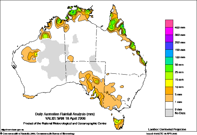
Todays highest rainfall totals for the 24 hours to 9am. It
includes the top 5 totals nationally followed by all reported falls of 50mm or more. |
Highest
and lowest recordings of hours of sunshine for the 24 hours to midnight. |
Highest wind
run totals in kilometres for the 24 hours to 9am (average speed in brackets).
All reported runs >
=25km/h are shown. |
Highest wind
gusts in km/h for the 24 hours to midnight followed by the hour in which it occurred.
All stations with gusts >
89km/h are shown. |
157.0 TOPAZ N Coast--Barron QLD
143.4 SHIPTONS FLAT N Coast--Barron QLD
135.0 HOPE VALE N Coast--Barron QLD
91.4 GRAHAM RANGE N Coast--Barron QLD
89.0 TOPAZ ALERT N Coast--Barron QLD
NORTHERN TERRITORY
N Rivers
87.0 BEATRICE HILL
64.6 GERIATRIC PARK
63.2 MCMINNS LAGOON
63.2 MANTON DAM
61.0 LAKE BENNETT
60.2 BATCHELOR AERO
56.0 FORT HILL WHARF
55.2 HOWARD SPRINGS
54.6 HUMPTY DOO COLLARD ROAD
53.0 HUMPTY DOO FIRE STATION
52.2 MIDDLE POINT AWS
50.0 ROSEBERY
QUEENSLAND
N Coast--Barron
157.0 TOPAZ
143.4 SHIPTONS FLAT
135.0 HOPE VALE
91.4 GRAHAM RANGE
89.0 TOPAZ ALERT
81.0 DAINTREE TEA
72.0 GLEN ALLYN
71.8 CAPE TRIBULATION STORE
55.0 KURANDA HILLTOP
55.0 HAPPY VALLEY
55.0 BABINDA SUGAR MILL
54.0 BARTLE VIEW ALERT
52.4 EVELYN STATE FOREST
N Coast--Herbert
52.0 NERADA ALERT
52.0 RUSSELL RIVER
50.0 CRAWFORDS LOOKOUT ALERT
50.0 TUNG OIL ALERT
50.0 JARRA CREEK TM
Central Coast E
51.0 DUMBLETON ROCKS ALERT
Wide Bay/Burnett
58.0 ELLIOTT HEADS ROAD
50.2 BURNETT HEADS NIELL ST
NEW SOUTH WALES
Hunter Valley
58.2 PATERSON POST OFFICE
TASMANIA
Central Plateau
71.6 BREONA (LOWER HAULAGE ROAD)
ISLANDS
Islands
57.4 CHRISTMAS ISLAND AERO
|
11.3 TENNANT CREEK AIRPORT N Plateau NT
11.0 ALICE SPRINGS AIRPORT N Plateau NT
11.0 RABBIT FLAT N Plateau NT
10.8 BROOME AIRPORT W Kimberley WA
10.8 COFFS HARBOUR MO MidNorth Coast N NSW
.....
3.1 SYDNEY AIRPORT AMO Sydney--east NSW
3.0 ORANGE AGRICULTURAL INSTITUTE C Tablelands S NSW
2.9 ADELAIDE AIRPORT Adelaide/Lofty SA
1.5 WELLINGTON (AGROWPLOW) CW Slopes S NSW
0.2 CAIRNS AERO N Coast--Barron QLD
|
1528 (63.7) THREDBO AWS Snowy Mtns NSW
1436 (59.8) MT HOTHAM Upper NE VIC
1260 (52.5) MOUNT WELLINGTON Southeast TAS
1192 (49.7) MOUNT READ W Coast TAS
1164 (48.5) NEPTUNE ISLAND W Agricultural SA
991 (41.3) CAPE GRIM BAPS N Coast TAS
985 (41.0) COLAC (MT GELLIBRAND) W Coast VIC
984 (41.0) LOW ISLES LIGHTHOUSE N Coast--Barron QLD
978 (40.8) TASMAN ISLAND Southeast TAS
948 (39.5) CAPE WILLOUGHBY Yorke Pen/Kanga Is SA
944 (39.3) KILMORE GAP N Central VIC
930 (38.8) RUNDLE ISLAND Wide Bay/Burnett QLD
928 (38.7) HOGAN ISLAND Islands ISL
916 (38.2) DOUBLE ISLAND POINT LIGHTHOUSE Brisbane/SE Coast QLD
905 (37.7) CAPE JAFFA (CURLEY HILLS) Lower SE SA
890 (37.1) MOUNT BULLER Upper NE VIC
882 (36.8) KING ISLAND AIRPORT King Island TAS
842 (35.1) TOOWOOMBA AIRPORT Darling Downs E QLD
812 (33.8) DUNNS HILL E Central VIC
804 (33.5) HAMILTON AIRPORT W Coast VIC
802 (33.4) CAPE BORDA AWS Yorke Pen/Kanga Is SA
794 (33.1) MELBOURNE AIRPORT E Central VIC
794 (33.1) BALLARAT AERODROME Western Plains VIC
782 (32.6) STRAHAN AERODROME W Coast TAS
772 (32.2) CAPE FLATTERY N Coast--Barron QLD
759 (31.6) MORTLAKE RACECOURSE W Coast VIC
756 (31.5) NORTH ISLAND Central West WA
755 (31.5) MAATSUYKER ISLAND LIGHTHOUSE Southeast TAS
753 (31.4) MINLATON AERO Yorke Pen/Kanga Is SA
753 (31.4) SWAN ISLAND E Coast TAS
751 (31.3) LADY ELLIOT ISLAND Wide Bay/Burnett QLD
741 (30.9) LOOKOUT HILL Western Plains VIC
735 (30.6) EDDYSTONE POINT E Coast TAS
734 (30.6) CARNARVON AIRPORT W Gascoyne WA
697 (29.0) FLINDERS ISLAND AIRPORT Flinders Is/Bass St TAS
694 (28.9) CAPE NELSON LIGHTHOUSE W Coast VIC
691 (28.8) WILSONS PROMONTORY LIGHTHOUSE W Gippsland VIC
687 (28.6) WARRNAMBOOL AIRPORT NDB W Coast VIC
684 (28.5) ROBE AIRFIELD Lower SE SA
668 (27.8) STENHOUSE BAY Yorke Pen/Kanga Is SA
665 (27.7) SCOTTS PEAK DAM W Coast TAS
657 (27.4) COULTA (COLES POINT) W Agricultural SA
657 (27.4) PORTLAND (CASHMORE AIRPORT) W Coast VIC
652 (27.2) SMITHTON AERODROME N Coast TAS
642 (26.8) CAPE OTWAY LIGHTHOUSE W Coast VIC
640 (26.7) ADELAIDE AIRPORT Adelaide/Lofty SA
618 (25.8) MT HOTHAM AIRPORT Upper NE VIC
617 (25.7) ESSENDON AIRPORT E Central VIC
614 (25.6) TUNNACK FIRE STATION Southeast TAS
607 (25.3) CAPE LEEUWIN Lower West WA
605 (25.2) DEVONPORT AIRPORT N Coast TAS
603 (25.1) MOUNT CRAWFORD FIRE TOWER Adelaide/Lofty SA
|
128/22 MAATSUYKER ISLAND LIGHTHOUSE Southeast TAS
124/02 THREDBO AWS Snowy Mtns NSW
124/02 MOUNT WELLINGTON Southeast TAS
122/03 SCOTTS PEAK DAM W Coast TAS
120/00 MT HOTHAM Upper NE VIC
120/00 MOUNT READ W Coast TAS
109/04 SWAN ISLAND E Coast TAS
109/05 TASMAN ISLAND Southeast TAS
104/03 HOGAN ISLAND Islands ISL
102/00 DUNNS HILL E Central VIC
100/04 CAPE GRIM BAPS N Coast TAS
98/00 COLAC (MT GELLIBRAND) W Coast VIC
95/03 DEVONPORT AIRPORT N Coast TAS
94/05 WILSONS PROMONTORY LIGHTHOUSE W Gippsland VIC
93/00 MOUNT BULLER Upper NE VIC
93/04 LAUNCESTON (TI TREE BEND) N Coast TAS
93/04 EDDYSTONE POINT E Coast TAS
91/00 KILMORE GAP N Central VIC
91/03 SHEFFIELD SCHOOL FARM N Coast TAS
|
�