|
For notes on how to interpret
the data and quality control issues, see Daily Weather Summary Help.
**S** and **W** precede data flagged by the Bureau as suspicious or wrong
Data is as received at 22:35EST, 14/05/2012.
|
|
| |
Max
°
C |
+/- norm
°
C |
Min
°
C |
+/- norm
°
C |
Grass Min
°
C |
Rain to 9am mm |
Evaporation to 9am mm |
Sunshine hours |
Wind Run to 9am km (24-hour average km/h) |
Maximum Gust km/h / hour of occurrence |
| GERALDTON AIRPORT |
23.9 |
-3.7 |
11.6 |
-3.8 |
9.7 |
0.0 |
5.2 |
-- |
428 (17.8) |
37/14 |
| PERTH AIRPORT |
22.8 |
-2.7 |
12.0 |
-0.9 |
9.9 |
0.0 |
3.2 |
8.1 |
278 (11.6) |
34/14 |
| ALBANY AIRPORT |
19.8 |
-2.0 |
13.0 |
+1.4 |
11.9 |
3.6 |
3.6 |
8.6 |
385 (16.0) |
32/06 |
| BUNBURY |
22.2 |
-1.9 |
11.1 |
-0.4 |
-- |
0.4 |
-- |
-- |
244 (10.2) |
31/16 |
| MANDURAH |
21.5 |
-- |
16.0 |
-- |
-- |
0.0 |
-- |
-- |
242 (10.1) |
34/04 |
| DARWIN AIRPORT |
32.6 |
-0.1 |
23.6 |
-0.4 |
22.2 |
0.0 |
7.2 |
10.0 |
389 (16.2) |
46/11 |
| ALICE SPRINGS AIRPORT |
24.3 |
-3.9 |
6.4 |
-6.2 |
2.0 |
0.0 |
8.0 |
11.1 |
309 (12.9) |
39/14 |
| WHYALLA AERO |
18.7 |
-4.9 |
5.0 |
-6.6 |
-- |
0.0 |
5.2 |
-- |
248 (10.3) |
28/13 |
| ADELAIDE (KENT TOWN) |
18.6 |
-4.0 |
7.1 |
-5.3 |
3.2 |
0.0 |
3.2 |
5.1 |
149 ( 6.2) |
21/13 |
| MOUNT GAMBIER AERO |
15.3 |
-4.1 |
9.8 |
+1.1 |
7.5 |
2.4 |
1.0 |
2.1 |
344 (14.3) |
35/11 |
| MOUNT ISA AERO |
28.8 |
-3.1 |
17.9 |
-0.6 |
-- |
0.0 |
-- |
-- |
456 (19.0) |
35/05 |
| CAIRNS AERO |
27.1 |
-2.1 |
22.0 |
+0.4 |
21.3 |
4.6 |
1.0 |
1.5 |
415 (17.3) |
39/06 |
| TOWNSVILLE AERO |
29.2 |
-0.4 |
21.3 |
+0.8 |
19.8 |
2.4 |
1.6 |
7.0 |
228 ( 9.5) |
41/11 |
| MACKAY M.O |
26.5 |
-0.2 |
18.2 |
-1.9 |
-- |
0.0 |
-- |
9.7 |
409 (17.0) |
41/10 |
| ROCKHAMPTON AERO |
29.4 |
+0.6 |
17.6 |
-0.2 |
16.9 |
0.0 |
4.8 |
-- |
166 ( 6.9) |
26/10 |
| BUNDABERG AERO |
27.4 |
0.0 |
17.4 |
-0.1 |
-- |
0.0 |
5.2 |
-- |
392 (16.3) |
34/10 |
| NAMBOUR DPI |
24.9 |
-1.2 |
13.2 |
-2.2 |
-- |
0.0 |
-- |
-- |
-- |
-- |
| COOLANGATTA |
24.3 |
-1.0 |
15.5 |
-1.5 |
-- |
0.0 |
-- |
-- |
353 (14.7) |
34/14 |
| BRISBANE AERO |
24.7 |
-1.3 |
14.2 |
-2.0 |
11.5 |
0.0 |
6.4 |
9.7 |
392 (16.3) |
28/14 |
| TOOWOOMBA AIRPORT |
23.5 |
+0.1 |
11.8 |
-1.5 |
-- |
0.0 |
-- |
-- |
423 (17.6) |
35/00 |
| GUNNEDAH (DIPNR) |
20.7 |
-4.4 |
4.5 |
-8.3 |
-0.1 |
0.0 |
4.4 |
-- |
120 ( 5.0) |
-- |
| COFFS HARBOUR MO |
21.6 |
-2.4 |
8.9 |
-6.3 |
4.2 |
0.0 |
5.4 |
10.5 |
281 (11.7) |
30/23 |
| PORT MACQUARIE AIRPORT AWS |
22.2 |
-1.8 |
5.9 |
-7.8 |
-- |
0.0 |
-- |
-- |
-- |
-- |
| WILLIAMTOWN RAAF |
21.9 |
-1.7 |
2.1 |
-11.1 |
-0.5 |
0.0 |
3.8 |
10.7 |
-- |
37/12 |
| GOSFORD (NARARA RESEARCH STATION) AWS |
21.1 |
-2.5 |
1.5 |
-10.4 |
-2.3 |
0.0 |
-- |
-- |
69 ( 2.9) |
22/08 |
| ORANGE AGRICULTURAL INSTITUTE |
12.8 |
-5.7 |
-1.6 |
-8.8 |
-7.2 |
0.0 |
2.4 |
10.2 |
-- |
-- |
| DUBBO AIRPORT AWS |
19.2 |
-5.3 |
0.1 |
-10.0 |
-- |
0.0 |
-- |
-- |
-- |
-- |
| SYDNEY AIRPORT AMO |
19.3 |
-3.6 |
8.2 |
-5.9 |
3.5 |
0.0 |
5.6 |
10.7 |
303 (12.6) |
41/10 |
| RICHMOND RAAF |
21.7 |
-2.2 |
-0.4 |
-11.7 |
-- |
0.0 |
-- |
-- |
84 ( 3.5) |
34/16 |
| BELLAMBI AWS |
19.4 |
-2.7 |
10.4 |
-5.0 |
-- |
0.0 |
-- |
-- |
288 (12.0) |
39/01 |
| CANBERRA AIRPORT |
17.3 |
-2.7 |
-2.1 |
-8.8 |
-4.7 |
0.0 |
3.0 |
10.3 |
211 ( 8.8) |
32/16 |
| WAGGA WAGGA AMO |
18.6 |
-3.9 |
2.0 |
-7.1 |
-1.0 |
0.0 |
3.6 |
7.4 |
253 (10.5) |
39/13 |
| ALBURY AIRPORT AWS |
17.0 |
-5.4 |
5.8 |
-2.2 |
-- |
0.0 |
-- |
-- |
159 ( 6.6) |
30/13 |
| MILDURA AIRPORT |
17.3 |
-6.2 |
2.5 |
-7.6 |
-0.9 |
0.0 |
2.4 |
3.1 |
180 ( 7.5) |
26/15 |
| TATURA INST SUSTAINABLE AG |
16.8 |
-4.8 |
4.1 |
-4.1 |
3.4 |
0.0 |
-- |
-- |
224 ( 9.3) |
30/10 |
| BENDIGO AIRPORT |
15.8 |
-5.4 |
2.9 |
-4.5 |
-- |
0.0 |
-- |
-- |
177 ( 7.4) |
�
30/15 |
| MELBOURNE REGIONAL OFFICE |
16.3 |
-4.0 |
10.7 |
-0.1 |
9.5 |
0.0 |
2.4 |
-- |
177 ( 7.4) |
22/00 |
| GEELONG AIRPORT |
14.7 |
-5.3 |
10.1 |
+0.8 |
-- |
0.0 |
-- |
-- |
516 (21.5) |
41/00 |
| BALLARAT AERODROME |
13.2 |
-4.4 |
6.8 |
-0.6 |
-- |
1.0 |
-- |
-- |
411 (17.1) |
35/12 |
| LAUNCESTON (TI TREE BEND) |
15.3 |
-3.6 |
2.0 |
-5.5 |
-- |
0.0 |
-- |
-- |
180 ( 7.5) |
21/13 |
| HOBART AIRPORT |
13.1 |
-5.0 |
6.6 |
-2.1 |
2.2 |
0.8 |
1.8 |
7.7 |
435 (18.1) |
37/06 |
| |
Max
°
C |
+/- norm
°
C |
Min
°
C |
+/- norm
°
C |
Grass Min
°
C |
Rain to 9am mm |
Evaporation to 9am mm |
Sunshine hours |
Wind Run to 9am km |
Maximum Gust km/h / hour of occurrence |
|
| Hottest |
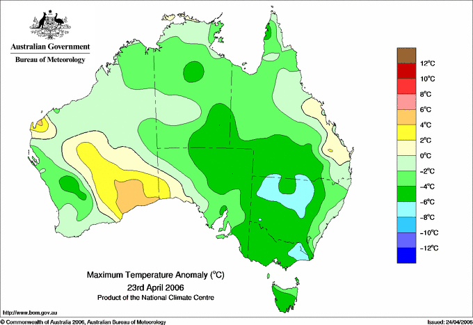
| Highest maximum temperature> | Greatest variation above normal maximum |
Highest minimum temperature | Greatest variation above normal minimum |
37.9 ONSLOW W Pilbara WA
35.8 MANDORA E Pilbara WA
35.3 LEARMONTH AIRPORT W Pilbara WA
35.2 BIDYADANGA W Kimberley WA
35.1 MARDIE W Pilbara WA
|
+8.5 : 32.5 EYRE Eucla WA
+4.9 : 28.5 EUCLA Eucla WA
+4.7 : 37.9 ONSLOW W Pilbara WA
+4.7 : 31.0 BALGAIR Eucla WA
|
29.0 PARDOO STATION E Pilbara WA
27.0 TROUGHTON ISLAND N Kimberley WA
26.9 MCCLUER ISLAND N Rivers NT
26.9 VARANUS ISLAND Islands ISL
26.7 BLACK POINT N Rivers NT
|
+7.3 : 29.0 PARDOO STATION E Pilbara WA
+4.5 : 24.1 WOLLOGORANG N Rivers NT
+4.2 : 19.5 BRIAN PASTURES Brisbane/SE Coast QLD
+3.4 : 14.1 WITCHCLIFFE Lower West WA
+3.3 : 18.6 LEINSTER AERO Goldfields WA
|
| Coldest |
| Lowest maximum temperature | Greatest variation below normal maximum |
Lowest minimum temperature | Greatest variation below normal minimum |
-0.1 MOUNT WELLINGTON Southeast TAS
1.4 MOUNT READ W Coast TAS
1.6 MT BAW BAW W Gippsland VIC
3.6 FALLS CREEK Upper NE VIC
3.6 MT HOTHAM Upper NE VIC
|
-8.2 : 1.6 MT BAW BAW W Gippsland VIC
-8.1 : -0.1 MOUNT WELLINGTON Southeast TAS
-7.4 : 10.3 BOMBALA AWS Goulburn/Monaro NSW
-7.4 : 11.7 MT NOWA NOWA E Gippsland VIC
-7.4 : 1.4 MOUNT READ W Coast TAS
|
-6.0 CHARLOTTE PASS (KOSCIUSKO CHALET) Snowy Mtns NSW
-5.6 BRAIDWOOD RACECOURSE AWS South Coast NSW
-5.5 COOMA AIRPORT AWS Goulburn/Monaro NSW
-5.0 BATHURST AGRICULTURAL STATION C Tablelands S NSW
-5.0 NERRIGA COMPOSITE South Coast NSW
|
-12.4 : -3.0 PARKES AIRPORT AWS CW Slopes S NSW
-11.8 : -0.7 CAMDEN AIRPORT AWS Illawarra NSW
-11.8 : -5.0 NERRIGA COMPOSITE South Coast NSW
-11.7 : -5.0 BATHURST AGRICULTURAL STATION C Tablelands S NSW
-11.7 : -0.4 RICHMOND RAAF Sydney--west NSW
|
|
Sunniest &
dullest |
Windiest |
Highest gusts |
Todays highest rainfall totals for the 24 hours to 9am. It
includes the top 5 totals nationally followed by all reported falls of 50mm or more. |
Highest
and lowest recordings of hours of sunshine for the 24 hours to midnight. |
Highest wind
run totals in kilometres for the 24 hours to 9am (average speed in brackets).
All reported runs >
=25km/h are shown. |
Highest wind
gusts in km/h for the 24 hours to midnight followed by the hour in which it occurred.
All stations with gusts >
89km/h are shown. |
104.0 HEATHLANDS NATIONAL PARK N Peninsula QLD
100.0 BRAMWELL N Peninsula QLD
94.0 GRAHAM RANGE N Coast--Barron QLD
87.5 ALCAN MINESITE N Rivers NT
61.4 GOVE AIRPORT N Rivers NT
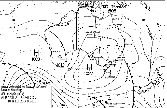
NORTHERN TERRITORY
N Rivers
87.5 ALCAN MINESITE
61.4 GOVE AIRPORT
56.0 YIRRKALA TROPICAL GARDENS
QUEENSLAND
N Peninsula
104.0 HEATHLANDS NATIONAL PARK
100.0 BRAMWELL
50.8 HORN ISLAND
N Coast--Barron
94.0 GRAHAM RANGE
|
11.2 BROOME AIRPORT W Kimberley WA
11.2 GILES METEOROLOGICAL OFFICE Interior WA
11.1 TENNANT CREEK AIRPORT N Plateau NT
11.1 ALICE SPRINGS AIRPORT N Plateau NT
11.1 RABBIT FLAT N Plateau NT
.....
0.8 KAIRI RESEARCH STATION N Coast--Barron QLD
0.5 NORFOLK ISLAND AERO Islands ISL
0.0 GOVE AIRPORT N Rivers NT
0.0 WEIPA AERO N Peninsula QLD
0.0 WARWICK Darling Downs E QLD
|
1484 (61.8) HOGAN ISLAND Islands ISL
1309 (54.5) WILSONS PROMONTORY LIGHTHOUSE W Gippsland VIC
1111 (46.3) MAATSUYKER ISLAND LIGHTHOUSE Southeast TAS
1033 (43.0) FLINDERS ISLAND AIRPORT Flinders Is/Bass St TAS
1023 (42.6) LOW HEAD N Coast TAS
972 (40.5) MOUNT WELLINGTON Southeast TAS
960 (40.0) MOUNT READ W Coast TAS
831 (34.6) CAPE MORETON LIGHTHOUSE Brisbane/SE Coast QLD
830 (34.6) HARTZ MOUNTAIN (KEOGHS PIMPLE) Southeast TAS
821 (34.2) CAPE OTWAY LIGHTHOUSE W Coast VIC
810 (33.8) HAMILTON ISLAND AIRPORT Central Coast E QLD
792 (33.0) CAPE BRUNY (CAPE BRUNY) Southeast TAS
772 (32.2) CAPE LEEUWIN Lower West WA
769 (32.0) SWAN ISLAND E Coast TAS
762 (31.8) KING ISLAND AIRPORT King Island TAS
744 (31.0) CENTRE ISLAND N Rivers NT
741 (30.9) THREDBO AWS Snowy Mtns NSW
725 (30.2) COLAC (MT GELLIBRAND) W Coast VIC
720 (30.0) DOUBLE ISLAND POINT LIGHTHOUSE Brisbane/SE Coast QLD
714 (29.8) TASMAN ISLAND Southeast TAS
668 (27.8) MORWELL (LATROBE VALLEY AIRPORT) W Gippsland VIC
667 (27.8) CAPE NATURALISTE Lower West WA
659 (27.5) RUNDLE ISLAND Wide Bay/Burnett QLD
651 (27.1) SCOTTS PEAK DAM W Coast TAS
649 (27.0) LADY ELLIOT ISLAND Wide Bay/Burnett QLD
647 (27.0) LIAWENEE Central Plateau TAS
634 (26.4) TENNANT CREEK AIRPORT N Plateau NT
607 (25.3) DEVONPORT AIRPORT N Coast TAS
601 (25.0) EAST SALE AIRPORT W Gippsland VIC
|
100/06 WILSONS PROMONTORY LIGHTHOUSE W Gippsland VIC
91/02 TASMAN ISLAND Southeast TAS
87/00 HOGAN ISLAND Islands ISL
81/05 GOVE AIRPORT N Rivers NT
78/04 HARTZ MOUNTAIN (KEOGHS PIMPLE) Southeast TAS
|
�