 |
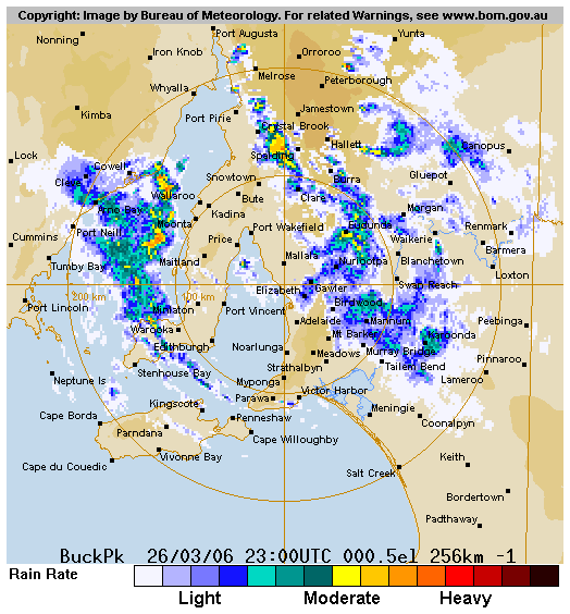
The low level circulation that enhanced rainfall in SA's Lower North moves to the NW of Adelaide in this radar image for 9.30am CDST.
Click the image for a 1.8mb animation and description that show more clearly the sequence of rainfall events that set records around the state. |
 SA: Record March rain causes flooding in mid north SA: Record March rain causes flooding in mid north
March rainfall records fell today in parts of the Eyre and Yorke Peninsulas and Kangaroo Island, and an area from the Lower North to the Barossa Valley. Some locations had their heaviest March falls in over a century.
The rain was heaviest to the southeast of Port Pirie where there were reports of 100 to 150mm, with unofficial reports of 80 to 100mm falling in one hour. In an area around Crystal Brook, Jamestown, Spalding and Yacka, flash flooding scoured roads and gardens and damaged bridges and kilometres of fencing. Spalding's main street was awash and houses and shops inundated as 80mm fell in an hour. Buildings in Jamestown were also flooded.
While this extraordinary event covered a wide area, it unfortunately missed Bureau automatic weather and rainfall stations that would have given detailed measurements of when and how heavily the rain fell. The heaviest rain also occurred around 9 this morning, the cut-off time when rainfall observers measure their 24-hour totals, so that storm totals were often split in two.
At Spalding, the observer reported 14.8mm in the 24 hours to 9 this morning, then 94.2mm in the 24 hours to 9am on Tuesday 28 March. This was nearly half as much again as the previous all-time one-day record of 66.0mm in 104 years of observations.
At Yacka, the downpour was split fairly evenly either side of the 9am cut-off, otherwise the all-time one-day record of 90.9mm would have fallen. Both this morning's reading of 56.0mm and the Tuesday reading of 62.6 broke the previous record for March (46.7mm) in 122 years of observations.
Other long-standing March records to fall were Coulta on the lower Eyre Peninsula (56.6mm, previous highest 41.4 in 114 years) and Tanunda in the Barossa Valley (53.6, previous highest 51.8 in 123 years). These were both recorded in the 24 hours to 9 this morning. Details of other record falls are below for today and here for Tuesday.
Several favourable factors aligned to produce the torrential rain. A very slow-moving trough system that moved through the area yesterday and early today (see surface charts below) dragged a narrow tongue of warm, moist air across the region. Behind the surface trough, a deep upper low and attendant cold pool moved ENE to be centred over the region late this morning. This air was exceptionally cold for March, dropping as low as -20 at 500hPa, just under 6km above the surface. In response to this, a circulation developed in the lower atmosphere around dawn, centred just NW of Adelaide. A strong area of uplift developed to the north of this circulation, the combined outcome of instability caused by cold air aloft, convergence caused by the developing low-level circulation, and the additional lifting effect of the entry to a jet stream, which just happened to be passing by in the higher atmosphere. South of the circulation, Adelaide recorded just 13.2mm in the 48 hours to 9am Tuesday.
Click the radar image to see the development of the circulation and for details of the sequence of events. The animation is 1.8mb.
Prs Ext Rec Not War Rdr Cht Rfl Rec
|