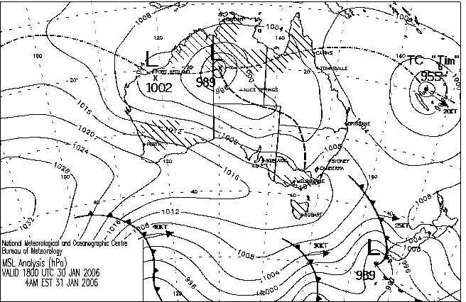
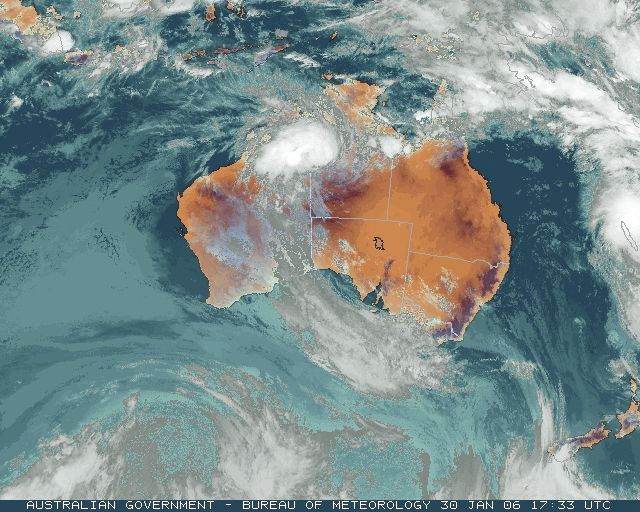
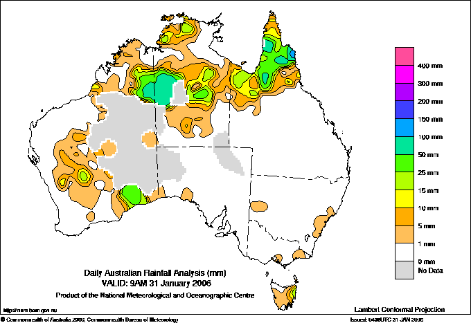
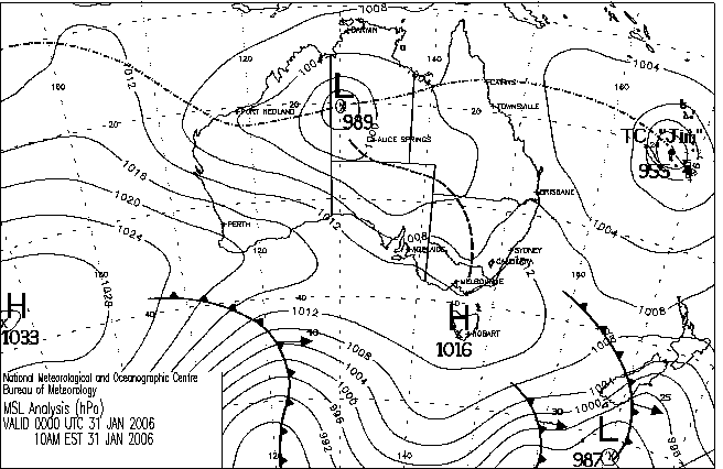
|
For notes on how to interpret
the data and quality control issues, see Daily Weather Summary Help.
**S** and **W** precede data flagged by the Bureau as suspicious or wrong
Data is as received at 22:11EST, 14/05/2012.
|
|
| |
Max
°
C |
+/- norm
°
C |
Min
°
C |
+/- norm
°
C |
Grass Min
°
C |
Rain to 9am mm |
Evaporation to 9am mm |
Sunshine hours |
Wind Run to 9am km (24-hour average km/h) |
Maximum Gust km/h / hour of occurrence |
| GERALDTON AIRPORT |
26.3 |
-5.3 |
14.9 |
-3.4 |
13.5 |
0.0 |
9.6 |
-- |
728 (30.3) |
63/15 |
| PERTH AIRPORT |
25.8 |
-5.8 |
13.1 |
-3.8 |
10.5 |
0.0 |
8.2 |
13.1 |
605 (25.2) |
41/14 |
| ALBANY AIRPORT |
20.2 |
-4.5 |
11.1 |
-2.6 |
8.1 |
0.0 |
4.2 |
10.5 |
338 (14.1) |
39/12 |
| BUNBURY |
26.9 |
-2.5 |
10.6 |
-4.5 |
-- |
0.0 |
-- |
-- |
360 (15.0) |
43/19 |
| MANDURAH |
23.4 |
-- |
13.4 |
-- |
-- |
0.2 |
-- |
-- |
412 (17.2) |
48/20 |
| DARWIN AIRPORT |
31.7 |
-0.1 |
25.3 |
+0.5 |
24.4 |
4.4 |
7.2 |
9.8 |
869 (36.2) |
61/11 |
| ALICE SPRINGS AIRPORT |
38.0 |
+1.6 |
26.6 |
+5.2 |
25.7 |
0.0 |
15.4 |
12.3 |
598 (24.9) |
48/21 |
| WHYALLA AERO |
31.8 |
+1.9 |
20.6 |
+3.2 |
-- |
0.0 |
14.6 |
-- |
717 (29.9) |
63/20 |
| ADELAIDE (KENT TOWN) |
31.2 |
+2.1 |
16.3 |
-0.7 |
13.5 |
0.0 |
6.4 |
11.8 |
315 (13.1) |
41/00 |
| MOUNT GAMBIER AERO |
22.4 |
-2.8 |
12.9 |
+1.8 |
12.5 |
0.0 |
6.4 |
2.9 |
495 (20.6) |
41/12 |
| MOUNT ISA AERO |
33.1 |
-3.2 |
24.0 |
+0.2 |
24.0 |
8.2 |
3.8 |
6.3 |
321 (13.4) |
-- |
| CAIRNS AERO |
31.0 |
-0.4 |
24.3 |
+0.6 |
24.0 |
0.4 |
3.6 |
5.9 |
230 ( 9.6) |
32/12 |
| TOWNSVILLE AERO |
31.1 |
-0.2 |
23.7 |
-0.5 |
21.5 |
0.0 |
6.4 |
12.1 |
266 (11.1) |
30/12 |
| MACKAY M.O |
31.3 |
+1.2 |
21.9 |
-1.6 |
-- |
0.0 |
-- |
11.5 |
290 (12.1) |
22/23 |
| ROCKHAMPTON AERO |
34.2 |
+2.3 |
22.1 |
0.0 |
20.7 |
0.0 |
8.6 |
-- |
226 ( 9.4) |
32/15 |
| BUNDABERG AERO |
-- |
-- |
20.2 |
-1.2 |
-- |
0.0 |
8.6 |
-- |
281 (11.7) |
-- |
| NAMBOUR DPI |
30.2 |
+0.9 |
18.8 |
-0.6 |
-- |
0.0 |
3.7 |
-- |
-- |
-- |
| COOLANGATTA |
30.3 |
+2.2 |
21.3 |
+0.3 |
-- |
0.0 |
-- |
-- |
380 (15.8) |
46/14 |
| BRISBANE AERO |
30.3 |
+1.3 |
20.8 |
-0.3 |
18.8 |
0.0 |
6.6 |
12.5 |
377 (15.7) |
43/14 |
| TOOWOOMBA AIRPORT |
30.5 |
+2.4 |
17.2 |
-0.3 |
-- |
0.0 |
-- |
-- |
491 (20.5) |
48/08 |
| GUNNEDAH (DIPNR) |
36.2 |
+4.3 |
21.9 |
+3.1 |
14.6 |
0.0 |
11.0 |
-- |
241 (10.0) |
-- |
| COFFS HARBOUR MO |
28.7 |
+1.8 |
21.1 |
+1.7 |
18.8 |
0.0 |
6.0 |
10.6 |
281 (11.7) |
34/16 |
| PORT MACQUARIE AIRPORT AWS |
28.8 |
+1.4 |
19.0 |
+0.9 |
-- |
0.0 |
-- |
-- |
-- |
-- |
| WILLIAMTOWN RAAF |
25.8 |
-2.1 |
20.7 |
+2.7 |
18.1 |
1.0 |
8.8 |
1.9 |
419 (17.5) |
35/07 |
| GOSFORD (NARARA RESEARCH STATION) AWS |
24.8 |
-2.7 |
18.5 |
+1.8 |
19.6 |
2.6 |
-- |
-- |
183 ( 7.6) |
34/00 |
| ORANGE AGRICULTURAL INSTITUTE |
30.5 |
+4.0 |
16.5 |
+3.3 |
13.0 |
0.0 |
6.0 |
12.0 |
-- |
-- |
| DUBBO AIRPORT AWS |
37.3 |
+4.2 |
23.9 |
+5.8 |
-- |
0.0 |
-- |
-- |
-- |
-- |
| SYDNEY AIRPORT AMO |
26.5 |
+0.1 |
18.6 |
-0.1 |
16.5 |
2.4 |
8.4 |
0.2 |
686 (28.6) |
59/00 |
| RICHMOND RAAF |
27.0 |
-2.8 |
18.2 |
+0.8 |
-- |
0.8 |
-- |
-- |
261 (10.9) |
41/23 |
| BELLAMBI AWS |
24.6 |
-0.2 |
17.9 |
-1.0 |
-- |
2.0 |
-- |
-- |
508 (21.2) |
50/01 |
| CANBERRA AIRPORT |
29.6 |
+1.6 |
13.9 |
+0.7 |
12.0 |
0.0 |
12.4 |
12.5 |
396 (16.5) |
41/19 |
| WAGGA WAGGA AMO |
37.6 |
+6.0 |
20.4 |
+4.2 |
19.6 |
0.0 |
9.8 |
12.6 |
372 (15.5) |
32/08 |
| ALBURY AIRPORT AWS |
35.6 |
+3.4 |
19.2 |
+2.6 |
-- |
0.0 |
-- |
-- |
-- |
-- |
| MILDURA AIRPORT |
34.3 |
+2.1 |
16.9 |
+0.3 |
16.7 |
0.0 |
14.6 |
13.1 |
-- |
32/14 |
| TATURA INST SUSTAINABLE AG |
28.8 |
-0.7 |
13.6 |
-0.5 |
12.9 |
0.0 |
9.8 |
-- |
616 (25.7) |
35/03 |
| BENDIGO AIRPORT |
30.2 |
+0.7 |
13.1 |
-0.8 |
-- |
0.0 |
-- |
-- |
511 (21.3) |
�
34/08 |
| MELBOURNE REGIONAL OFFICE |
24.9 |
-1.0 |
14.6 |
+0.3 |
12.8 |
0.8 |
3.4 |
-- |
171 ( 7.1) |
28/16 |
| GEELONG AIRPORT |
22.5 |
-2.1 |
15.2 |
+2.1 |
-- |
0.0 |
-- |
-- |
484 (20.2) |
48/13 |
| BALLARAT AERODROME |
23.7 |
-1.3 |
10.7 |
-0.1 |
-- |
0.0 |
-- |
-- |
659 (27.5) |
48/09 |
| LAUNCESTON (TI TREE BEND) |
21.2 |
-3.0 |
8.3 |
-3.8 |
-- |
2.6 |
-- |
-- |
181 ( 7.5) |
30/16 |
| HOBART AIRPORT |
19.7 |
-2.8 |
8.7 |
-3.3 |
5.9 |
4.0 |
4.0 |
5.3 |
355 (14.8) |
32/15 |
| |
Max
°
C |
+/- norm
°
C |
Min
°
C |
+/- norm
°
C |
Grass Min
°
C |
Rain to 9am mm |
Evaporation to 9am mm |
Sunshine hours |
Wind Run to 9am km |
Maximum Gust km/h / hour of occurrence |
|
| Hottest |
| Highest maximum temperature> | Greatest variation above normal maximum |
Highest minimum temperature | Greatest variation above normal minimum |
45.6 MARREE NE Pastoral SA
45.4 BALLERA GAS FIELD Far SW QLD
45.3 MARREE AERO NE Pastoral SA
45.0 ANDAMOOKA NW Pastoral SA
45.0 ROXBY DOWNS (OLYMPIC DAM AERODROME) NW Pastoral SA
|
+9.2 : 43.6 WOOMERA AERODROME NW Pastoral SA
+8.8 : 44.2 LEIGH CREEK AIRPORT NE Pastoral SA
+8.6 : 45.0 ANDAMOOKA NW Pastoral SA
+8.1 : 41.0 QUANDIALLA POST OFFICE SW Slopes N NSW
+8.1 : 40.7 WYALONG POST OFFICE SW Slopes N NSW
|
31.6 BIRDSVILLE AIRPORT Channel Country QLD
30.4 TIBOOBURRA POST OFFICE Far Northwest NSW
30.2 TIBOOBURRA AIRPORT Far Northwest NSW
30.1 MARREE AERO NE Pastoral SA
30.0 MARREE NE Pastoral SA
|
+9.1 : 28.6 NYNGAN AIRPORT CW Plains N NSW
+8.7 : 30.0 MARREE NE Pastoral SA
+8.6 : 30.4 TIBOOBURRA POST OFFICE Far Northwest NSW
+8.2 : 28.8 COBAR AIRPORT AWS Upper Darling NSW
+8.1 : 28.6 COBAR MO Upper Darling NSW
|
| Coldest |
| Lowest maximum temperature | Greatest variation below normal maximum |
Lowest minimum temperature | Greatest variation below normal minimum |
11.8 MOUNT WELLINGTON Southeast TAS
13.3 MOUNT READ W Coast TAS
15.2 HARTZ MOUNTAIN (KEOGHS PIMPLE) Southeast TAS
15.5 WEEAPROINAH W Coast VIC
16.0 WARRA W Coast TAS
|
-19.8 : 17.4 LEINSTER AERO Goldfields WA
-19.5 : 18.4 YEELIRRIE Goldfields WA
-18.2 : 18.8 LEONORA Goldfields WA
-17.8 : 20.0 WILUNA Interior WA
-17.2 : 18.1 LAVERTON AERO Goldfields WA
|
-0.1 LIAWENEE Central Plateau TAS
1.8 LAKE ST CLAIR NATIONAL PARK Central Plateau TAS
2.0 MOUNT WELLINGTON Southeast TAS
2.8 LAKE LEAKE (ELIZABETH RIVER) E Coast TAS
3.3 TARRALEAH VILLAGE Derwent Valley TAS
|
-10.5 : 13.8 MEEKATHARRA AIRPORT E Gascoyne WA
-10.2 : 12.9 LEINSTER AERO Goldfields WA
-9.3 : 13.5 WILUNA Interior WA
-9.1 : 13.0 YEELIRRIE Goldfields WA
-8.6 : 14.6 MOUNT MAGNET AERO E Gascoyne WA
|
|
Sunniest &
dullest |
Windiest |
Highest gusts |
Todays highest rainfall totals for the 24 hours to 9am. It
includes the top 5 totals nationally followed by all reported falls of 50mm or more. |
Highest
and lowest recordings of hours of sunshine for the 24 hours to midnight. |
Highest wind
run totals in kilometres for the 24 hours to 9am (average speed in brackets).
All reported runs >
=25km/h are shown. |
Highest wind
gusts in km/h for the 24 hours to midnight followed by the hour in which it occurred.
All stations with gusts >
89km/h are shown. |
239.0 SUPLEJACK N Rivers NT
154.0 HAZELMERE N Coast--Barron QLD
153.2 MOUNT OLIVE N Coast--Barron QLD
150.5 PORMPURAAW TOWNSHIP Gulf Country QLD
119.6 BIRRINDUDU N Rivers NT
WESTERN AUSTRALIA
E Kimberley
60.0 STURT CREEK
56.0 LAMBOO
Interior
73.8 BALGO HILLS
NORTHERN TERRITORY
N Rivers
239.0 SUPLEJACK
119.6 BIRRINDUDU
76.0 LAJAMANU
N Plateau
60.0 RABBIT FLAT
QUEENSLAND
N Peninsula
109.0 KENDALL RIVER STATION
85.6 SOUTHWELL STATION
S Peninsula
89.6 PALMERVILLE
64.0 FAIRVIEW OUTSTATION
54.2 PINNACLE
52.0 GAMBOOLA STATION
Gulf Country
150.5 PORMPURAAW TOWNSHIP
60.6 COWAN DOWNS STATION
52.6 CROYDON TOWNSHIP
Upper Carpentaria
82.0 EVELEIGH STATION
N Coast--Barron
154.0 HAZELMERE
153.2 MOUNT OLIVE
109.6 COOKTOWN MISSION STRIP
102.6 CAPE FLATTERY
100.8 COOKTOWN AIRPORT
83.0 BUTCHER HILL STATION
56.5 LIZARD ISLAND RESORT
|
13.1 PERTH AIRPORT Lower West WA
13.1 MILDURA AIRPORT Mallee N VIC
13.0 MOREE AERO NW Plains E NSW
12.8 WOOMERA AERODROME NW Pastoral SA
12.6 WAGGA WAGGA AMO SW Slopes S NSW
.....
1.8 WEIPA AERO N Peninsula QLD
1.6 SCOTTSDALE (WEST MINSTONE ROAD) N Coast TAS
0.2 SYDNEY AIRPORT AMO Sydney--east NSW
0.1 NORFOLK ISLAND AERO Islands ISL
0.0 RABBIT FLAT N Plateau NT
|
961 (40.0) NEPTUNE ISLAND W Agricultural SA
953 (39.7) NORTH ISLAND Central West WA
945 (39.4) POINT FAWCETT Islands ISL
943 (39.3) VARANUS ISLAND Islands ISL
940 (39.2) NGAYAWILI N Rivers NT
902 (37.6) CEDUNA AMO W Agricultural SA
869 (36.2) DARWIN AIRPORT N Rivers NT
869 (36.2) NOARLUNGA Adelaide/Lofty SA
866 (36.1) STENHOUSE BAY Yorke Pen/Kanga Is SA
851 (35.5) BARROW ISLAND AIRPORT W Pilbara WA
850 (35.4) MINNIPA DPI W Agricultural SA
837 (34.9) CAPE GRIM BAPS N Coast TAS
831 (34.6) CARNARVON AIRPORT W Gascoyne WA
828 (34.5) MAATSUYKER ISLAND LIGHTHOUSE Southeast TAS
827 (34.5) EDITHBURGH Yorke Pen/Kanga Is SA
816 (34.0) KILMORE GAP N Central VIC
815 (34.0) HOGAN ISLAND Islands ISL
813 (33.9) NORTH SHIELDS (PORT LINCOLN AWS) W Agricultural SA
811 (33.8) KARRATHA AERO E Pilbara WA
810 (33.8) MOUNT CRAWFORD FIRE TOWER Adelaide/Lofty SA
803 (33.5) MINLATON AERO Yorke Pen/Kanga Is SA
800 (33.3) LEIGH CREEK AIRPORT NE Pastoral SA
794 (33.1) WILSONS PROMONTORY LIGHTHOUSE W Gippsland VIC
782 (32.6) DOUBLE ISLAND POINT LIGHTHOUSE Brisbane/SE Coast QLD
781 (32.5) MOUNT WELLINGTON Southeast TAS
773 (32.2) THEVENARD ISLAND W Pilbara WA
773 (32.2) CLEVE AERODROME W Agricultural SA
753 (31.4) WOOMERA AERODROME NW Pastoral SA
750 (31.3) CAPE LEEUWIN Lower West WA
745 (31.0) CAPE MORETON LIGHTHOUSE Brisbane/SE Coast QLD
733 (30.5) GREEN CAPE AWS South Coast NSW
728 (30.3) GERALDTON AIRPORT Central West WA
726 (30.3) MANGALORE AIRPORT N Central VIC
717 (29.9) WHYALLA AERO W Agricultural SA
714 (29.8) SHARK BAY AIRPORT W Gascoyne WA
686 (28.6) SYDNEY AIRPORT AMO Sydney--east NSW
685 (28.5) PORT HEDLAND AIRPORT E Pilbara WA
669 (27.9) WALPEUP RESEARCH Mallee N VIC
664 (27.7) WUDINNA AERO W Agricultural SA
663 (27.6) THREDBO AWS Snowy Mtns NSW
661 (27.5) LEARMONTH AIRPORT W Pilbara WA
661 (27.5) REDESDALE N Central VIC
659 (27.5) BALLARAT AERODROME Western Plains VIC
657 (27.4) EUCLA Eucla WA
653 (27.2) LAVERTON AERO Goldfields WA
651 (27.1) FLINDERS ISLAND AIRPORT Flinders Is/Bass St TAS
646 (26.9) KUITPO FOREST RESERVE Adelaide/Lofty SA
641 (26.7) LOOKOUT HILL Western Plains VIC
638 (26.6) KINGSCOTE AERO Yorke Pen/Kanga Is SA
637 (26.5) MORAWA AIRPORT Central West WA
637 (26.5) HARTZ MOUNTAIN (KEOGHS PIMPLE) Southeast TAS
634 (26.4) CAPE JAFFA (CURLEY HILLS) Lower SE SA
626 (26.1) COULTA (COLES POINT) W Agricultural SA
624 (26.0) RABBIT FLAT N Plateau NT
624 (26.0) COOBER PEDY AIRPORT NW Pastoral SA
622 (25.9) ONSLOW AIRPORT W Pilbara WA
616 (25.7) TATURA INST SUSTAINABLE AG Upper North VIC
612 (25.5) GOVE AIRPORT N Rivers NT
612 (25.5) LONGERENONG Wimmera S VIC
611 (25.5) ROEBOURNE AERO E Pilbara WA
609 (25.4) GOLD COAST SEAWAY Brisbane/SE Coast QLD
608 (25.3) MOUNT READ W Coast TAS
605 (25.2) PERTH AIRPORT Lower West WA
605 (25.2) RUNDLE ISLAND Wide Bay/Burnett QLD
604 (25.2) MARREE AERO NE Pastoral SA
600 (25.0) FORREST Eucla WA
|
91/21 RABBIT FLAT N Plateau NT
85/17 YULARA AERO N Plateau NT
83/06 NGAYAWILI N Rivers NT
78/16 CENTRAL ARNHEM PLATEAU N Rivers NT
76/22 WILSONS PROMONTORY LIGHTHOUSE W Gippsland VIC
|
�