|
 AUS: Winter heatwave
concludes AUS: Winter heatwave
concludes
The heatwave that has affected every state and territory over the past week
finally broke down today as colder air and significant rainbands pushed across
southeastern states (see below). Today, 11 locations across the NT, NSW and
TAS set or equalled previous record June high maxima (see records below),
the most significant being Launceston Airport where the top of 17.3 knocked
0.6C off the 66-year record. A further 28 locations in WA, NT, NSW, the ACT,
VIC and TAS came within a degree of their previous June highs including Alice
Springs and many stations on the NSW Central and Southern Tablelands.
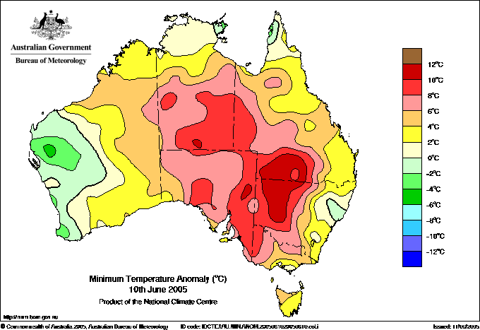
Cloud moving into western NSW and SW QLD trapped yesterday's heat, producing
some remarkably high overnight minima for the third day in a row. Wanaaring
NSW's low of 16.9 was 0.1 above yesterday's and 11.4 above normal. Minima in
most of this area were between 8 and 11 higher than average and equivalent
to March norms.
 |
| Hourly water vapour images from 6am to midnight
EST dramatically demonstrate the impact of a northwest moisture feed coinciding
with a southern cold front. Dark areas are relatively dry through the depth
of the atmosphere. Increasingly lighter shades of grey through to white
indicate progressively higher levels of moisture. Weatherzone, BoM |
SE
AUS:
Rain and storms bring much-needed rain
After four months of negligible rain, the right conditions for widespread
soaking falls at last came together today over SA, western NSW and VIC. A strong
northwesterly jet
stream
across central Australia dragged moisture from the Indian Ocean into SE AUS,
and this coincided with the arrival of a colder, moist and unstable airmass
from the west. The rain followed some useful falls in western VIC yesterday.
The water vapour satellite images above show that three separate cloudmasses
produced the rain. As the animation begins at 6am EST, an area of abundant
moisture can be seen extending from SE SA through western VIC into western
NSW. This was associated with convergence along a change of wind direction
in the middle atmosphere from northerly to northwesterly, and brought general
light rain as it moved SE, finally decaying over the Gippsland during the evening.
The second rain area is moving around the eastern flank of the low shown
in the Bight in the surface chart at the top of the page. This low was a mixing
pot of cold southerly air and tropical moisture, and lightning trackers through
the day showed a vast field of lightning activity embracing the entire Bight
region. From the 4pm to 8pm images, a thin white line can be seen crossing
the Adelaide region and moving into SA. This marks the passage
of the front and a line of thunderstorms which dropped 15 to 30mm as they passed
and caused devastation in Karoonda, 80km E of Murray Bridge (see separate story).
The third and most significant rain area appears almost like a comet, hurtling
across Central Australia during the day, then seemingly exploding as it curls
SSE into VIC during the evening and interacts with the colder unstable airmass
moving in from the west. This is the northwesterly moisture band, and the interaction
produced falls of 15 to 50mm, reaching 90mm in the Alps, across most of VIC
and the western half of NSW by 9am Saturday. During Saturday, this system continued
to give widespread moderate to heavy rain as it amplified SE into northern
TAS and NE into eastern NSW and southern QLD. Further details are given in
the Daily Weather Summary for 11
JUN.
 |

Adelaide radar from 4.30pm CST (07.00 UTC) to
8.30pm CST (11.00 UTC) shows the line of thunderstorms that hit Adelaide
about 6pm and Karoonda shortly before 8pm. BoM |
 SA:
Severe storms sweep SE SA, devastate Karoonda SA:
Severe storms sweep SE SA, devastate Karoonda
The line of thunderstorms described above brought severe wind damage, flooding
and a probable tornado to SE SA. It crossed the Adelaide metropolitan
area about 6pm and moved through the southeast during the early evening,
gradually weakening.
The greatest damage occurred on the eastern side of the small town of Karoonda,
80km E of Murray Bridge, where 5 homes were destroyed and a further 12 or 13
homes
and
community
buildings severely damaged by a probable tornado shortly before 8pm. Damage
was estimated at $2m, and the SA Government announced the creation of a $250,000
relief fund for the town. Roofs were blown off buildings, a wall blown out
of the side of the CFA headquarters, and two steel light towers at the football
club were bent over, with the club itself sustaining severe damage. The hospital
and ambulance base were also badly damaged.
In Adelaide, roads and houses were flooded in northern and southern suburbs,
and $200,000 in damage caused in a house fire started by lightning at Salisbury
Heights. Police attended 27 road crashes, mainly linked to slippery roads after
the long dry spell. About 1,000 black-faced cormorant chicks perished in the
colony at Outer Harbour when they were washed from their nests.
Flooded roads were reported at Mt Torrens in the Adelaide Hills, McLaren
Vale, Moana, the Barossa Valley and Taree, while roads and houses were flooded
at Murray Bridge. The highest wind gust reported was 117km/h at Cape Jaffa,
20km N of Robe, at 7.37pm. Many locations reported very heavy rain; details
are in downpours below. The highest 24-hour
total to 9am Saturday was 42.0mm at South Para Reservoir, 13km SE of Gawler. |